All Activity
- Past hour
-
1988 had such an incredible hot summer, this is an example of what I mean when I say the heat was much more extensive and longer lasting in the 80s and 90s in the summer than it is now. This has nothing to do with Central Park foliage issues this was literally coast to coast heat that lasted the entire summer. Other examples include 1980, 1983, 1988, 1991, 1993, 1995, 1999, 2002. By the way in yesterday's post you mentioned that Boston's all time August high of 101 happened in 2002?
-
Missing landfall by inches is worse. The big island is square in the right front quad and not much weakening happens.
-
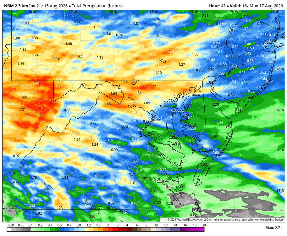
This looks nice Will !! I guess I can look forward to 1.40" rain the next 40 hrs. That's more than the total for the first half of August!!
-

Augdewst 2026: Summer's Last Stand
WxWatcher007 replied to Prismshine Productions's topic in New England
-
2026 C and E Pacific tropical activity
WxWatcher007 replied to GaWx's topic in Tropical Headquarters
G140 reported at Mauna Kea Summit!! Likely to be a close miss with regard to official landfall for the big island but some significant impacts showing up on damage reports across Hawaii. -
No argument. It's boring.
-
She has Central AC. It gets hot, which is looking more and more unlikely I'll just head over.
-

2026-2027 Record-breaking El Nino
ncjoaquin replied to Stormchaserchuck1's topic in Weather Forecasting and Discussion
It took you a decade and 30,000 plus posts to determine that nobody knows anything. You are sharp! -

2026-2027 Record-breaking El Nino
40/70 Benchmark replied to Stormchaserchuck1's topic in Weather Forecasting and Discussion
That looks centered on the PNW/SW Canada...could be worse. NAO-east, too. -
2026-2027 Record-breaking El Nino
40/70 Benchmark replied to Stormchaserchuck1's topic in Weather Forecasting and Discussion
He does not know his shit, which is why the nonsense-troll MO is so frustrating. ...every now and then, I get a DM from him on actual weather in the lead up to a huge event. -
Augdewst 2026: Summer's Last Stand
WxWatcher007 replied to Prismshine Productions's topic in New England
Man we need tropical -
Shes going to leave you once she finds out you uninstalled...
-
I figure I'll be in a good location. I can get to the entire NE coast in less then 8 hours drive. I can hit the coast of Maine or head all the way back down here in less then 8 hour. I'll be up at Barns Corner watching like a hawk. There's going to be some big storms somewhere this winter. I plan on being in the jackpot for most of them. My goal is 300" this season.
-
WB 21Z NBM for upcoming rain event.
-
Just about perfect evening. Even the GF agrees. And she doesn't like anything.
-
I plan on shutting down December 1 and hauling ass up north. If it's 50's up there and 70's here in December I'll stay open. I went to the Tug last January. When I came back it was like 70 for a week. I worked that entire week then shut it down. I make my annual income by December so I'm definitely not stressing. December, January, and the first couple weeks of February is my time to embrace my weirdness and focus on snowstorms. Let's schedule an estimate! I've got a few openings left in September and October. November is booked solid.
-
Warmed right back up again after the clouds moved out.
-
I’ll chime in to add my thoughts. They mirror everyone else’s but it probably will be below average LES. To get LES you need good deep cold air running over warm water with a westerly flow. Seems like a La Niña string of NS waves would be the best pattern for get that. Not to say you won’t get any, but you’ll be more reliant on hoping the southern stream can get storms far enough up the coast to so you can get into the westerly flow.
-

Augdewst 2026: Summer's Last Stand
VivaManchVegas replied to Prismshine Productions's topic in New England
Its happening... -

2026-2027 Record-breaking El Nino
JACKASS replied to Stormchaserchuck1's topic in Weather Forecasting and Discussion
I’ll admit that @forkyforkis an odd duck. However, as Kush (who has been banned for other reasons) made it clear, forky was one of the very few “icepussy” mets on this forum. Just a reminder. -

2026 Mid-Atlantic Severe Storm General Discussion
SnowenOutThere replied to Kmlwx's topic in Mid Atlantic
I’m finally coming back from Madison WI tonight/tomorrow so excited to see how it plays out. I think tomorrow might be okay. Already earlier this week we say some strong supercells hit along I-64. -
Low of 78, high of 94. Very humid out.
-

2026-2027 Record-breaking El Nino
michsnowfreak replied to Stormchaserchuck1's topic in Weather Forecasting and Discussion
There was a big 14.8" snowstorm Jan 31st. -
May be a winter hosting unusual anomaly/extremes around the hemisphere - more so than climo. For one, warm ENSOs are notorious for that, anyway, but as qc_omega intimated, with CC is providing underneath I find it difficult to imagine a better arena for synergistic feedback. Huge changeability that ranges between somewhat below normal to outlandishly above normal. Basically a bigger gap that usual, reposition on the warm side of climate. You know?
-

2026 Mid-Atlantic Severe Storm General Discussion
high risk replied to Kmlwx's topic in Mid Atlantic
Everything you said about the environment later tomorrow is spot on, but the one parameter you left out is cape, and that could certainly prevent a bigger day tomorrow. There is certainly solid model consensus for a “round 2” of storms later Sunday, but forecast soundings don’t look great. I certainly agree, though, that IF we can destabilize, supercells and tornadoes are on the table. Otherwise, it’s a noisy heavy rain event.- 1,911 replies
-
- 3
-

-
- severe
- thunderstorms
- (and 7 more)