All Activity
- Past hour
-
The 10 - 15 day features moisture trying to move northeast from the lower Mississippi valley. Confluence with LP over S.E Canada suppresses.
-

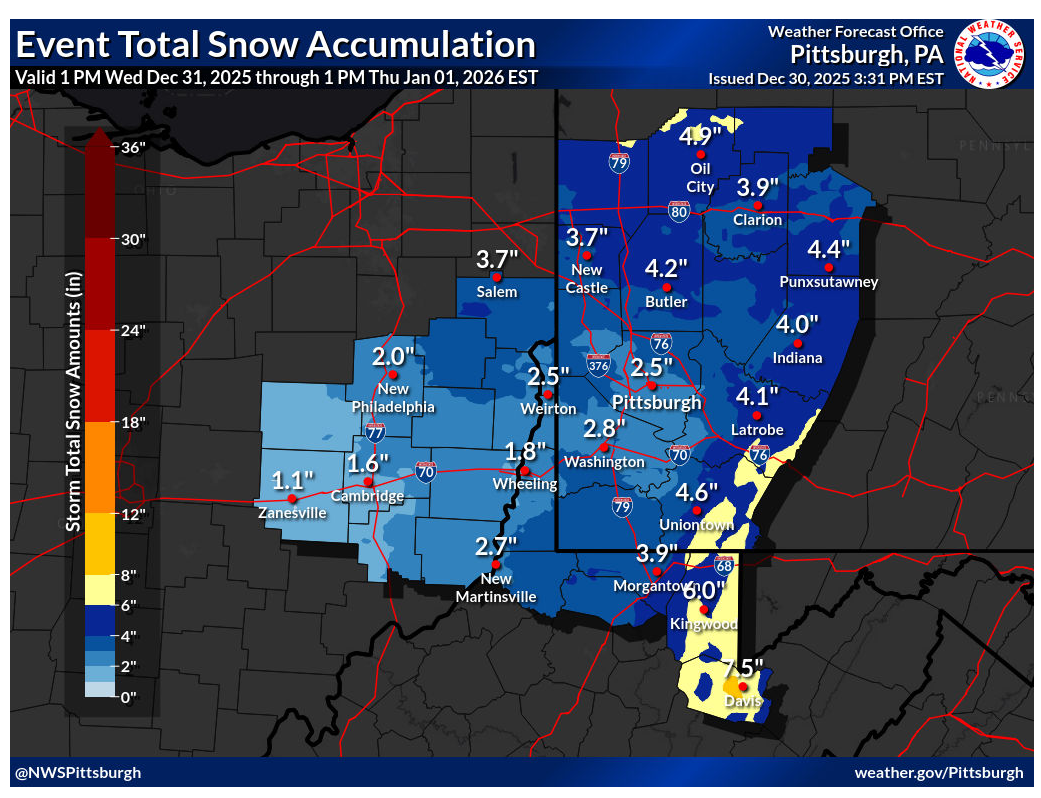
Pittsburgh/Western PA WINTER ‘25/‘26
colonel717 replied to Burghblizz's topic in Upstate New York/Pennsylvania

-
Temperatures briefly moderated in southwestern Manitoba, s SK and North Dakota, generally a little above freezing today, back into the deep freeze up there tonight. The milder air is making limited inroads into nw Ontario and Winnipeg region has warmed only into the mid-20s (F).
-

New Years Day 2026 - 1st snows of the new year possible
TauntonBlizzard2013 replied to Baroclinic Zone's topic in New England
18z RGEM gets the low going a little sooner and north. 3-5” for SE Mass and cape. I’d take it -
New Years Day 2026 - 1st snows of the new year possible
TauntonBlizzard2013 replied to Baroclinic Zone's topic in New England
What’s measurable? A dusting? I’m not sure there’s going to be a lot of 1” or more amounts unless we get the secondary assist -

New Years Day 2026 - 1st snows of the new year possible
Baroclinic Zone replied to Baroclinic Zone's topic in New England
I’m rolling with the RGEM on this one. Advisory snows in SE MA. -
New Years Day 2026 - 1st snows of the new year possible
TauntonBlizzard2013 replied to Baroclinic Zone's topic in New England
I broke my wrist in several places as a kid. Don’t recommend. Ruined my baseball career. -

12/31-1/1 Possible Snow Showers/Squalls to Start 2026
caviman2201 replied to bncho's topic in Mid Atlantic
Imma be out there at 3am like Jack Skellington if NAM 3k is right... -

January 2026 regional war/obs/disco thread
8611Blizz replied to Baroclinic Zone's topic in New England
Jonbenetramsay and pp smegma are correct. This pattern sucks. Thankfully they're here to let us know how shitty it is... -
Much ballyhooed “winter over” torch comprised of 4 days with 7,8,9 plus departures in a month with six double digit negatives and 22 of the 31 days negative values
-
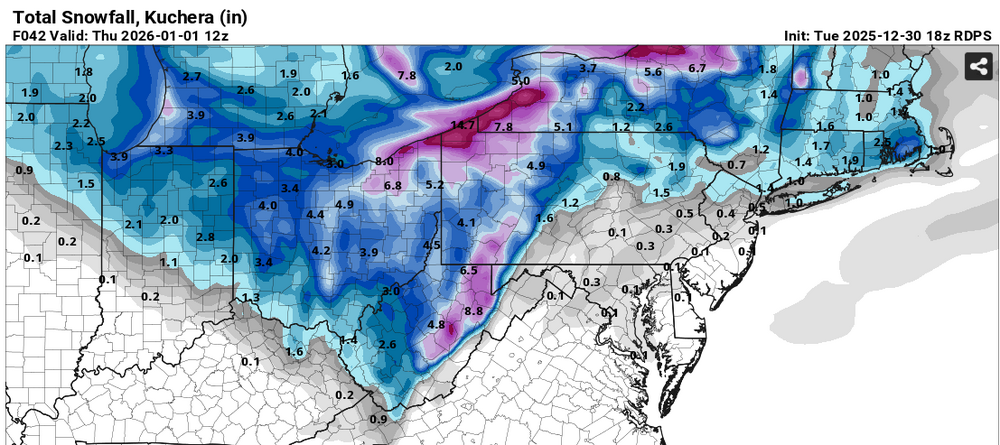
The EPS, GEPS and GEFS ensemble means for snowfall through 1/13, 12Z, generally dropped a decent amount in the last 24 hours (except for the GEPS north of NYC and not because any snow was forecast to fall over the last 24 hrs), presumably reflecting the pattern not being quite as good for cold and snow as it was 24 hours ago. On today's 12Z ensembles through 1/13, 12Z, Edison, NJ (25 miles SW of CPK, whose numbers look wonky on these graphics) dropped from 4.0" to 2.0" on the EPS, it fell from 3.5" to 2.8" on the GEPS and it fell from 3.5" to 2.3" on the GEFS. Picking one more point, White Plains dropped from 4.5" to 2.8 on the EPS, it jumped from 3.7" to 4.8" on the GEPS (the only increase) and it fell from 4.3" to 3.0" on the GEFS. Given how far out these go, I'm not even going to attempt to explain any of this - just noting a modest to significant decrease for most of the 95 corridor at least over the last 24 hours.
-
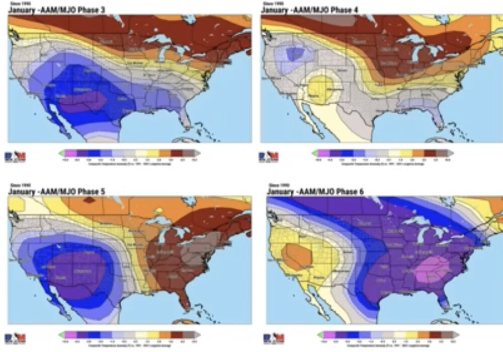
This was released by BAMwx: Thoughts? I’m going to need to research this myself to feel comfy with BAMwx’s idea of the highly counterintuitive idea of a very cold E US on average during La Niña (-AAM) Jan phase 6 periods. They’re saying this probably because GEFS is forecasting phase 6 going into mid-Jan as per my earlier MJO forecast post. I can do the analysis but it will take time. I’m planning to look at actual temp anoms for a city like ATL, Chat., Nashville, or GSP that’s in the heart of the coldest (pink) for all phase 6 days during Jan since 1975. Actually anyone can do it but one needs lots of time to do this. In the meantime, I’ll continue to root for weak to moderate 8-1-2 over 6 or even 7. @donsutherland1@bluewave
-

January 2026 regional war/obs/disco thread
moneypitmike replied to Baroclinic Zone's topic in New England
-
Pittsburgh/Western PA WINTER ‘25/‘26
colonel717 replied to Burghblizz's topic in Upstate New York/Pennsylvania
-
Crazy storm, ended up with 12" from the storm , then another 6" from LES last night. Calling for another 8-12" thru New Years. Finally got my power back this afternoon. After last season's snow/ice and this year just about ready to move somewhere much warmer.
-

New Years Day 2026 - 1st snows of the new year possible
kdxken replied to Baroclinic Zone's topic in New England
My daughter who is a orthopedic PA calls it distal radius fracture season . -
This thread is pure comedy sometimes, a play on emotional instability, the cause of rising psychotherapy costs in the southeast. Ridges gonna ridge.
-

New Years Day 2026 - 1st snows of the new year possible
HoarfrostHubb replied to Baroclinic Zone's topic in New England
Of course…biguns are preferable, and I see your point of view. But anything that can add to the “pack” and to my little ski area helps. -
New Years Day 2026 - 1st snows of the new year possible
kdxken replied to Baroclinic Zone's topic in New England
You mean like this?.jpg.bc27d18c54478a1ad219f71e96344bf1.jpg)
-

Pittsburgh/Western PA WINTER ‘25/‘26
Mailman replied to Burghblizz's topic in Upstate New York/Pennsylvania
Didn't do squat down here today; however, i did have to venture to Johnstown this morning. It was rippin' good on 711 between Donegal and Ligonier this morning. -
Final event snowfall totals1.5" - Home0.9" - ORD0.8" - RFD…2025/26 Season Snowfall...18.8" - RFD18.3" - ORD" - Home
-
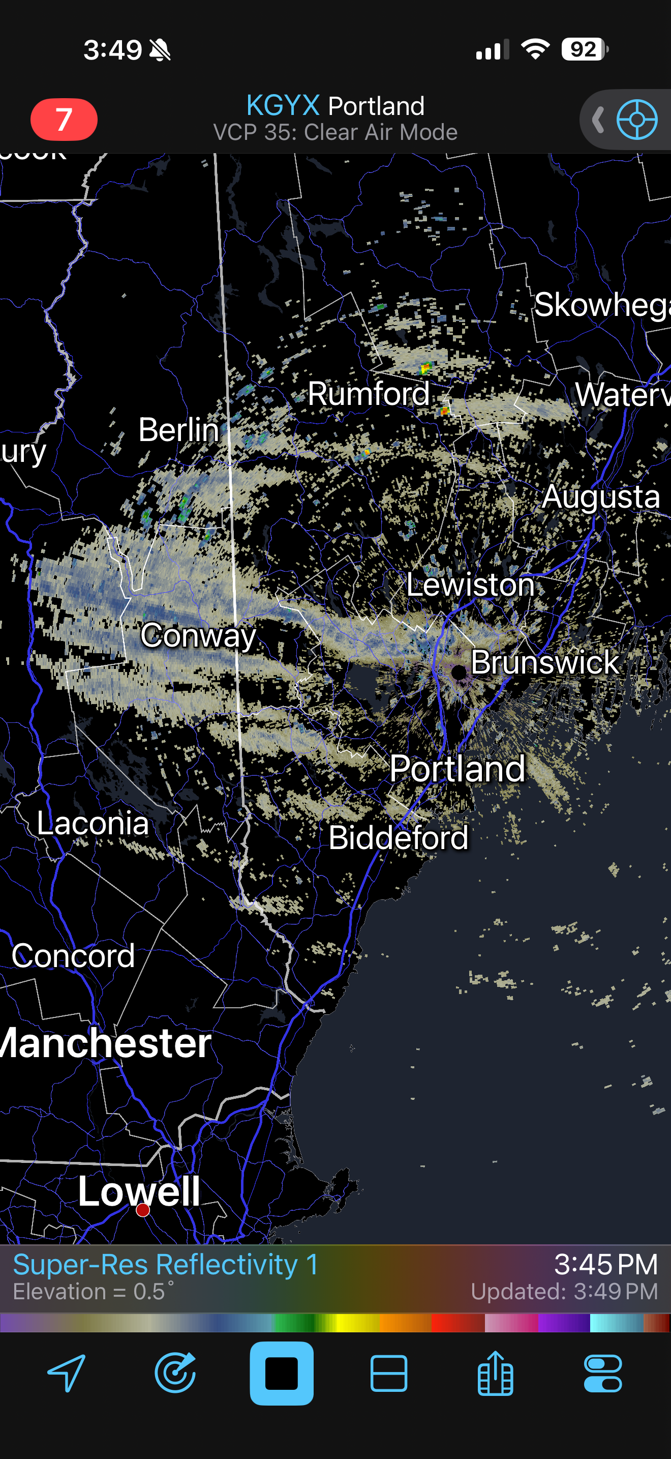
A few streamers moving thru the lakes region

-
I could see that 12-18" panning out near the lakeshore in far NE OH, especially in northern Ashtabula County, but Geauga County won't get that much IMO. The downside of grouping multiple counties together in a warning. It just seems like there will be too much of a break after snow lifts out of there tonight, and I think stuff will progress through too quickly with the cold front tomorrow evening. There's definitely a shot Geauga County verifies a warning at some point (they haven't yet...) but the 12-18" feels inflated there. We'll see, as I've been wrong before. Nice band ongoing at the moment.
-
Wouldn’t surprise me if east end of li ends up with 2”
-

New Years Day 2026 - 1st snows of the new year possible
ORH_wxman replied to Baroclinic Zone's topic in New England
Seems like most should get measurable but 2”+ will probably be in isolated pockets or out on/near Cape.