All Activity
- Past hour
-
'grats
-
Nice bit of rain. Went out when it was light and threw some grass seed down. Using this wet day also to finish a DIY project.

-
April 5 1999: Heavy snow falls over the Arrowhead, with 11 inches at Two Harbors. ^Note: We just had a 2 day snow total of 7.7" imby^ 1929: A tornado cuts a path from Lake Minnetonka through North Minneapolis and leaves six dead. For Sunday, April 5, 2026 1945 - The temperature at Eagles Nest, NM, plunged to 45 degrees below zero to establish an April record for the United States. (Sandra and TI Richard Sanders - 1987) 1955 - The Northern Rockies and the Northern High Plains were in the midst of a four day storm which produced 52 inches of snow at Lead, located in the Black Hills of western South Dakota. (David Ludlum) 1972 - A tornado, 500 yards wide at times, touched down at a marina on the Oregon side of the Columbia River, and then tore through Vancouver WA killing six persons, injuring 300 others, and causing more than five million dollars damage. It was the deadliest tornado of the year, and the worst of record for Washington. (The Weather Channel) 1982 - An unprecedented April blizzard began in the northeastern U.S. One to two feet of snow fell across Massachusetts and Connecticut, and up to 26 inches was reported in Maine. New York City received a foot of snow. Winds reached 70 to 80 mph during the storm, and the storm also produced numerous thunderstorms, which contributed to the heavy snow. (Storm Data) 1987 - A storm produced unprecedented April snows in the central Appalachians. Mount Mitchell NC received 35 inches of snow, and up to 60 inches (six feet) of snow was reported in the mountains along the border of North Carolina and Tennessee. The total of 25 inches at Charleston WV easily surpassed their previous record for the entire month of April of 5.9 inches. The 20.6 inch total at Akron OH established an all-time record for that location. (Storm Data) (The National Weather Summary) 1988 - Thirty-nine cities across the eastern half of the country reported record high temperatures for the date, including Saint Louis MO with a reading of 91 degrees. Laredo TX was the hot spot in the nation with an afternoon high of 100 degrees. (The National Weather Summary) 1989 - Unseasonably hot weather prevailed in the southwestern U.S. Afternoon highs of 100 degrees at Santa Maria CA and 105 degrees in Downtown Los Angeles established records for the month of April. (The National Weather Summary) 1990 - Afternoon and evening thunderstorms developing along a cold front produced severe weather in southern Oklahoma, southern Arkansas, and north central and northeastern Texas. Thunderstorms spawned a dozen tornadoes in Texas, including one at Fort Worth which caused a million dollars damage. There were nearly one hundred reports of large hail and damaging winds. Thunderstorms in Texas produced hail three and a half inches in diameter west of Fort Worth, and produced wind gusts to 80 mph at Cross Plains. (The National Weather Summary) (Storm Data)
-

2026-2027 El Nino
snowman19 replied to Stormchaserchuck1's topic in Weather Forecasting and Discussion
Verbatim, showing a very strong +IOD developing, along with a continued ++PMM… -
2.8" final tally. Happy Easter ev1!
-

Central PA Spring 2026 Discussion/Obs Thread
Blizzard of 93 replied to Voyager's topic in Upstate New York/Pennsylvania
Happy Easter! As a long time pro Met says every day, “Enjoy the weather, it’s the only weather you’ve got”! -
37.7° Heavy, heavy rain shower right now
-
.39 so far. Maybe we can squeeze out .5
-
Happy Easter, happy spring to all! And @mappy, here are some tulips for you!!


-

Central PA Spring 2026 Discussion/Obs Thread
mahantango#1 replied to Voyager's topic in Upstate New York/Pennsylvania
-
2026-2027 El Nino
snowman19 replied to Stormchaserchuck1's topic in Weather Forecasting and Discussion
This is starting to look like the “perfect storm” for causing a Bjerknes feedback loop/coupling to develop, which would cause this El Niño to become self-sustaining and self-reinforcing. We have the current record WWB/DWKW, coupled with the projected high amp, strong MJO wave propagating into the Pacific also supporting westerlies in the ENSO regions, a very strong +PMM, a developing +IOD and the “triplet” TC’s/typhoons in the PAC (causing another massive WWB/DWKW behind them)…. -
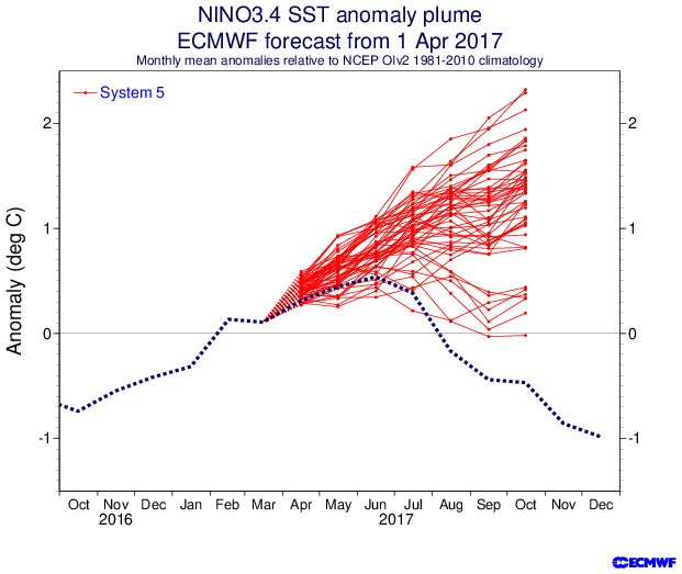
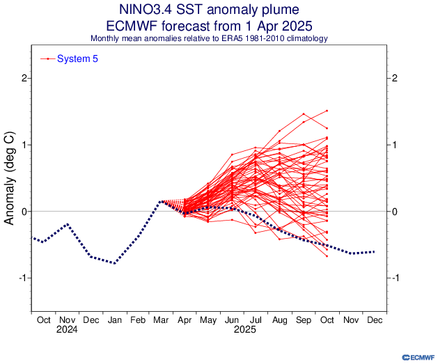
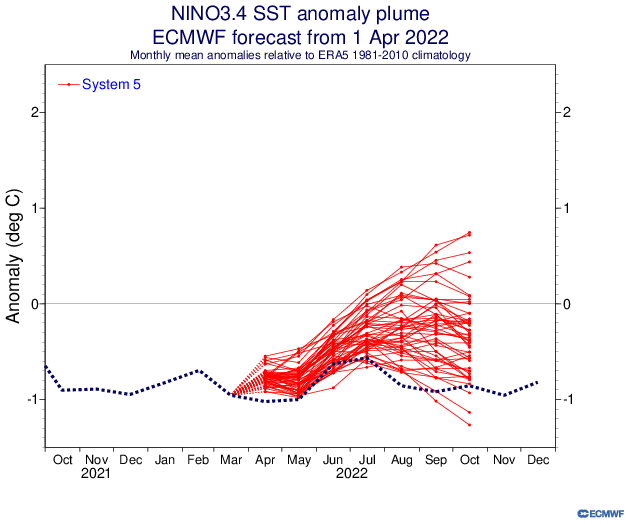
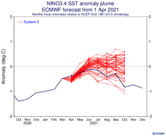
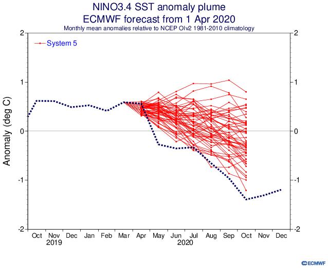
Thanks, Chris. 1. The April run comes in a bit stronger for ONI than the Mar run for the same months compared. For example, the Mar run had Sep at ~+2.1 vs the Apr run having Sep at ~+2.25. So, that’s clearly a bullish trend since the prior run for a stronger ONI. 2. RONI is still ~0.5 cooler than ONI. So, ~0.5 still needs to be subtracted off of the Euro output to approximate its implied RONI prog. 3. It’s important to still keep in mind a longterm warm bias of the Euro ONI progs based on the avg of ~20 years of progs though those that verify as El Niño have averaged a lower warm bias. Examples: -the April ‘17 run progged moderate El Niño (+1.1) for ASO (see below) vs it verifying way down at -0.3 for ONI, a whopping +1.4 miss. That’s an extreme, of course, but one doesn’t find misses anywhere near that same magnitude the other way. In addition, the April ‘14 run had ASO up at +1.5 vs verification only +0.3, another big miss of +1.2. Furthermore, the April ‘12 run had ASO up at +1.0 vs verification of only +0.4 for a +0.6 miss. Some recent April run ASO ONI misses have also been large to the too warm side: -2025: ASO prog of +0.4 vs actual of -0.4 for miss of +0.8 -2022: ASO prog of -0.3 vs actual of -1.0 for miss of +0.7 -2021: ASO prog of 0 vs actual of -0.6 for a miss of +0.6 2020: ASO prog of -0.1 vs actual of -0.9 for a miss of +0.8 So, based on the -0.5 RONI adj. and the notable Euro warm bias, the actual RONI peak could easily verify as only a moderate peak. My current wild guess is for low end strong RONI peak.
-
-
Records: Highs: EWR: 83 (1985) NYC: 80 (1928) LGA: 74 (1989) JFK: 73 (1988) Lows: EWR: 23 (1995) NYC: 20 (1874) LGA: 25 (1995) JFK: 24 (1995) Historical: 1815: The Tambora Volcano in Java began erupting on this day. A few days later on the 10, Tambora produced the largest eruption known on the planet in the last 10,000 years. Ash from the volcano would circle the globe, blocking sunlight and leading to the unusually cold summer in 1816. On 6/6/1816, snow would fall as far south of Connecticut with some places in New England picking up 10 inches. On July 4th, 1816, the temperature at Savannah GA plunged to 46 degrees. Eastern North America and Europe had freezing nighttime temperatures in August. 1849: Three inches of snow at Columbia, SC fell two weeks later than any previous record late freeze. (Ref. Wilson Wx. History) 1874: The temperature at Boston, MA plunged to 11° to establish the April low temperature record for that city. (Ref. Wilson Wx. History) 1881: The minimum temperature for the date is 24°F. in Washington, DC. (Ref. Washington Weather Records - KDCA) 1882: A tornado moved north-northeast from four miles east of Iuka, KS, passing through the town of Stafford. Many homes were unroofed or blown down in Stafford. Two mills were destroyed and a 700 pound millstone was moved 150 feet. One person was killed and 14 injured. (Ref. Wilson Wx. History) 1910: The maximum temperature for the date is 86°F. in Washington, DC. (Ref. Washington Weather Records - KDCA) 1923: A well-developed tornado in North Creek Park to Silver Spring Station; 11 mile path, 100-250 yards wide; $100,000 damage; 4 seriously injured. 1936: Approximately 454 people were killed in the second-deadliest tornado outbreak ever in U.S. More than 12 twisters struck Arkansas to South Carolina. An estimated F5 tornado cut a path 400 yards wide through the residential section of Tupelo, Mississippi. At least 216 people were killed, and 700 were injured. The tornado had a 15-mile long path and did $3 million in damage. One of the survivors in Tupelo was a baby of an economically strapped family who had an infant they'd recently named Elvis Aaron Presley. Gainesville, Georgia had at least 203 fatalities and 934 injuries from an estimated F4 tornado that occurred early the following morning. 1945 - The temperature at Eagles Nest, NM, plunged to 45 degrees below zero to establish an April record for the United States. (Sandra and TI Richard Sanders - 1987) 1955 - The Northern Rockies and the Northern High Plains were in the midst of a four day storm which produced 52 inches of snow at Lead, located in the Black Hills of western South Dakota. (David Ludlum) 1972 - A tornado, 500 yards wide at times, touched down at a marina on the Oregon side of the Columbia River, and then tore through Vancouver WA killing six persons, injuring 300 others, and causing more than five million dollars damage. It was the deadliest tornado of the year, and the worst of record for Washington. (The Weather Channel) 1982 - An unprecedented April blizzard began in the northeastern U.S. One to two feet of snow fell across Massachusetts and Connecticut, and up to 26 inches was reported in Maine. New York City received a foot of snow. Winds reached 70 to 80 mph during the storm, and the storm also produced numerous thunderstorms, which contributed to the heavy snow. (Storm Data) 1983: This event is listed by the Utah NWS as occurring on April 4th-5th, 1983. A severe canyon wind in the Wasatch Mountains of Utah produced wind gusts 60 to 80 mph with a peak gust of 104 mph. These winds overturned 12 flatbed railroad cars with loaded trailers on the Union Pacific line near Farmington. (Ref. Wilson Wx. History) 1987 - A storm produced unprecedented April snows in the central Appalachians. Mount Mitchell NC received 35 inches of snow, and up to 60 inches (six feet) of snow was reported in the mountains along the border of North Carolina and Tennessee. The total of 25 inches at Charleston WV easily surpassed their previous record for the entire month of April of 5.9 inches. The 20.6 inch total at Akron OH established an all-time record for that location. (Storm Data) (The National Weather Summary) 1988 - Thirty-nine cities across the eastern half of the country reported record high temperatures for the date, including Saint Louis MO with a reading of 91 degrees. Laredo TX was the hot spot in the nation with an afternoon high of 100 degrees. (The National Weather Summary) 1989 - Unseasonably hot weather prevailed in the southwestern U.S. Afternoon highs of 100 degrees at Santa Maria CA and 105 degrees in Downtown Los Angeles established records for the month of April. (The National Weather Summary) 1990 - Afternoon and evening thunderstorms developing along a cold front produced severe weather in southern Oklahoma, southern Arkansas, and north central and northeastern Texas. Thunderstorms spawned a dozen tornadoes in Texas, including one at Fort Worth which caused a million dollars damage. There were nearly one hundred reports of large hail and damaging winds. Thunderstorms in Texas produced hail three and a half inches in diameter west of Fort Worth, and produced wind gusts to 80 mph at Cross Plains. (The National Weather Summary) (Storm Data) 1995: Spring cold set 34 records in the NE and Great Lakes: Chicago 15°, Toledo 12°, Madison 14°, Boston 15°, Caribou 1° is coldest ever so late in season. 1996: A small area of west-central Texas was buried under record late season snows. Abilene recorded 9.3 inches in 24 hours for its greatest 24 hour snowfall ever. Sweetwater measured 18 inches. The 2 inches at Midland was its greatest April snowfall on record.(Ref. Wilson Wx. History) 1997: Heavy rains and melting snows pushed rivers in the Dakotas and Minnesota over their banks and left hundreds of people homeless while just to the west, a blizzard dumped as much as 10 inches of snow in the Black Hills of South Dakota. Bismarck, ND reported 17.3 inches to raise its seasonal snowfall to 101.4 inches; the city's snowiest winter on record. (Ref. Wilson Wx. History) 2001: An unusually strong dust devil formed in Suffolk County, NY on Long Island and moved across the Brookhaven Calabro Airport at Shirley, NY. The vortex lifted a Piper Cherokee Airplane 25 feet in the air and threw it. The 75 foot column of whirling dust formed under clear skies along a sea breeze front. (Ref. Wilson Wx. History)
-
57/54 Nice burst of mild and dews with some breaks
-
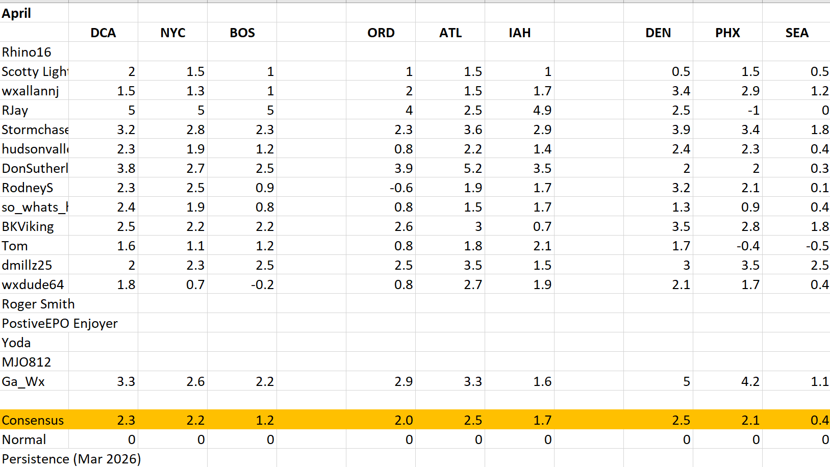
 Happy Easter. Here is a look at the monthly forecast, best of luck everyone. I will try to update consensus and normal into season totals and future updates, for consensus I just did median of the forecasts for each city. This seemed to be as close as I could get to consensus scoring as Roger did. I'll try to figure out how he did persistence going forward. Welcome Ga_Wx hope to see you more often. Starting in May we will continue on with forecasts submissions before May 1st 6z as we have done before. I will be a little lenient on penalties of 1% off every 6 hours late at first. Look to June forecast to be the time frame we do MAX temp forecasts for summer.
-
You put into words my exact sentiment of how this spring has rolled up here to date. One or two days of sun with AN temps just to crash back into 10 days of winter or near winter and endless streaks of gloom. And now a white Easter to kick the nuts again.
-
Nice little downpour rolling thru. Been chipping away at the drought here the last month or so.
-
52 / 52 mostly cloudy Easter morning. Front already pushing from CPA to EPA, a bit ahead of schedule. Showers, scattered storm Cooler Mon - Wed then ridge builds back east 4/10 - 4/16. Beyond there looks normal and perhaps increased storm chances.
-
sprinkles began 8:15. It has sprinkled its way to .01" at 9:15.
-
I agree it's early and baseball is a marathon. Something that has bothered me is all of these top prospects has been underwhelming except for Gunner. You can go through all of them and with the exception of Gunner non has lived up to there billing. Holiday- decent player but he was the overall #1 prospect for a good while. Doesn't look like the superstar he was made out to be. Cowser- not an everyday center fielder. Can't hit off speed pitching. Westburg - can't stay healthy. Adley. - huge regression for the last 1.5 years. Not only offensely but defensely too. Add all of this up and you end up with the last year and a half of Baltimore baseball. This has to change for the Orioles to get back into the post season. Edit - I forgot to add in Mayo. Huge bust potential here. It's early but early returns looks like he can't hit Major league quality pitching.
- Today
-
That might cause a divorce in my household
-
flowering cherry trees should all be cut down and replaced with natives
-
Got .25 in the showers yesterday. Another .15 overnight. Looks like some good showers to our west. We might get to an inch. Not a drought buster for sure but will give the farmers and my yard a little relief. Happy Easter SE friends!
-
Weak front moving through, MAYBE we wind up with a quarter inch of rain. The next 3 weeks look DRY.