All Activity
- Past hour
-
They are slow updating the map, but it’s winter storm warnings, ice storm warnings and winter weather advisories
-

January 2026 regional war/obs/disco thread
Typhoon Tip replied to Baroclinic Zone's topic in New England
It's a huge index signal centered around the 1st, + and/or - a couple of dates, which are derived from the ensembles. Somewhat ironic, the same ensemble mass -fields that are analyzed in deriving those index values, do not actually carry a significant event through that period This is troubling. Meanwhile, the operational versions have at least been off and on .. perhaps 50% of the time, plotting then not plotting significant events within that index-signaled window. That's what we are dealing with. Sometimes... the ensemble means will actually collapse toward the denser physically applied operational flagship version. Rarer...but does happen. If that is going to be the case this time... proooobably start to see some at least tentative operational agreement on which dates to center on. So far...we've really seen 29/30th to 02/03 and all dates in between. Not really centering... This may also come together/coalesce in guidance better after we get this present major off the boards. I will also add... purely from a climatology of major events historical perspective it is seldom that major winter storms occur in short order. We've seen two moderate impact events pull that off... aggregating to a major by weight of both kind of thing. But this thing on Sun/Mon ... then having an 06z GFS 5 days later is rarely observed. -
Yeah, I am one county to the south of the ice storm warnings and Helene with 100+ mph wind gusts ravaged my area. I hate the idea that some people that faced Helene will have to deal with this 1.5 years later.
-
Yeah I think 10 to 1 will definitely be too low to use in this storm unless you end up getting a prolonged period of sleet (seems unlikely for 95% of this forum) I’d prob go about 14 to 1 for the storm average. There’s gonna be a bit of wind too…not a lot but enough to prob keep us from stacking perfect dendrites.
-

January 24-26: Miracle or Mirage JV/Banter Thread!
RevWarReenactor replied to SnowenOutThere's topic in Mid Atlantic
NWS has been over forecasting for this area for quite sometime. I can count at least 5 storms in the last 10 years where they where saying 3-6 or even 4-8 and I got a dusting on the grass. Furthermore, the mixing ALWAYS happens way quicker than forecasted. -

Pittsburgh/Western PA WINTER ‘25/‘26
colonel717 replied to Burghblizz's topic in Upstate New York/Pennsylvania
Weird, my excitement was tempered and then getting NAM'd got me excited like you said, this could really happen. -

January 24-26: Miracle or Mirage JV/Banter Thread!
NorthArlington101 replied to SnowenOutThere's topic in Mid Atlantic
Partially to preserve my own sanity and grind expectations low, but yeah, kinda because of the NAM. Also matches the EURO as far as snow goes, really, perhaps a tad more conservative. I guess the sleet would probably make my map wrong but I'll never really count that as snow even if you are supposed to -
 not if the low goes south another 20 miles
 -
For east tn folks, this setup is where know your climo plays the biggest. Like I know that Tellico has realistically less than a 10% chance of significant icing (just way where situated), I know if I drive 5 mins up 68 into the Notchey Creek/Mt Vernon area their risk grows substantially (past history of power going out there in ice setups)
-

Possible Record Breaking Cold + Snow Sunday 1/25 - Tuesday 1/27
Wxbear25 replied to TriPol's topic in New York City Metro
I wouldnt worry about the 3K too much at this point. Take a look at it, see how its trending, but verbatim its not quite in its wheelhouse just yet -
12z NAM is interesting for the 84 corridor.. ❄️
-
Lol, the FV3 is super cold. That is its typical bias though so I wouldn't put much stock in it. It's got the sleet line still south of Philly by 0z Monday. Significant snows north of that across all of SE PA verbatim
-
I don't disagree with you- sub-zero DP take quite a bit of time and precip to overcome at the surface, but I am not sure how well this variable gets modeled by the NAM, plus or minus
-
Bump in Ice for sure. Snow/sleet print looks about the same
-
Actually no. If you’ve been paying attention SNE outside the immediate coast has been a sweet spot. Now I think the immediate coast is also in a great spot.
-
RE: snow:water ratio forecasting. Thought this would be a good book mark for folks.
-
MRX is working on that now. They are deciding which counties need an advisory and which need a warning. It should be out in a few minutes I think. They are also looking at the wind and what needs to be said about that.
-

Central PA Winter 25/26 Discussion and Obs
CarlislePaWx replied to MAG5035's topic in Upstate New York/Pennsylvania
This looks infinitely better than 0Z last night. My point-n-click gives me a range of 12" - 20". My prediction of 19.59" is still inside the NWS range...lol -
I just did a big forest cleanup from Helene. I lost a ton of trees. Please let this be mostly sleet
-

Possible Record Breaking Cold + Snow Sunday 1/25 - Tuesday 1/27
NEG NAO replied to TriPol's topic in New York City Metro
trying to pin this mix line down to a few miles is not going to work out this far in advance - so take it with a grain of salt today IMO -
That’s actually been the one thing that’s driving me nuts. I know @WxUSAF has joked about it in recent days, but sort of true at this point. Is what it is. I think this will end up being a monster sleet bomb south of I-66 at this juncture. Snow will rip in VA for a time though, so it’ll be one heck of a mess down there.
-

Possible Record Breaking Cold + Snow Sunday 1/25 - Tuesday 1/27
ag3 replied to TriPol's topic in New York City Metro
Great sign seeing the Nam get colder. -

Pittsburgh/Western PA WINTER ‘25/‘26
Ahoff replied to Burghblizz's topic in Upstate New York/Pennsylvania
Geez! That’s a good run. This might really happen guys! -
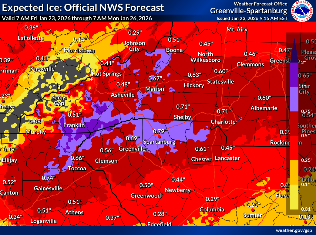
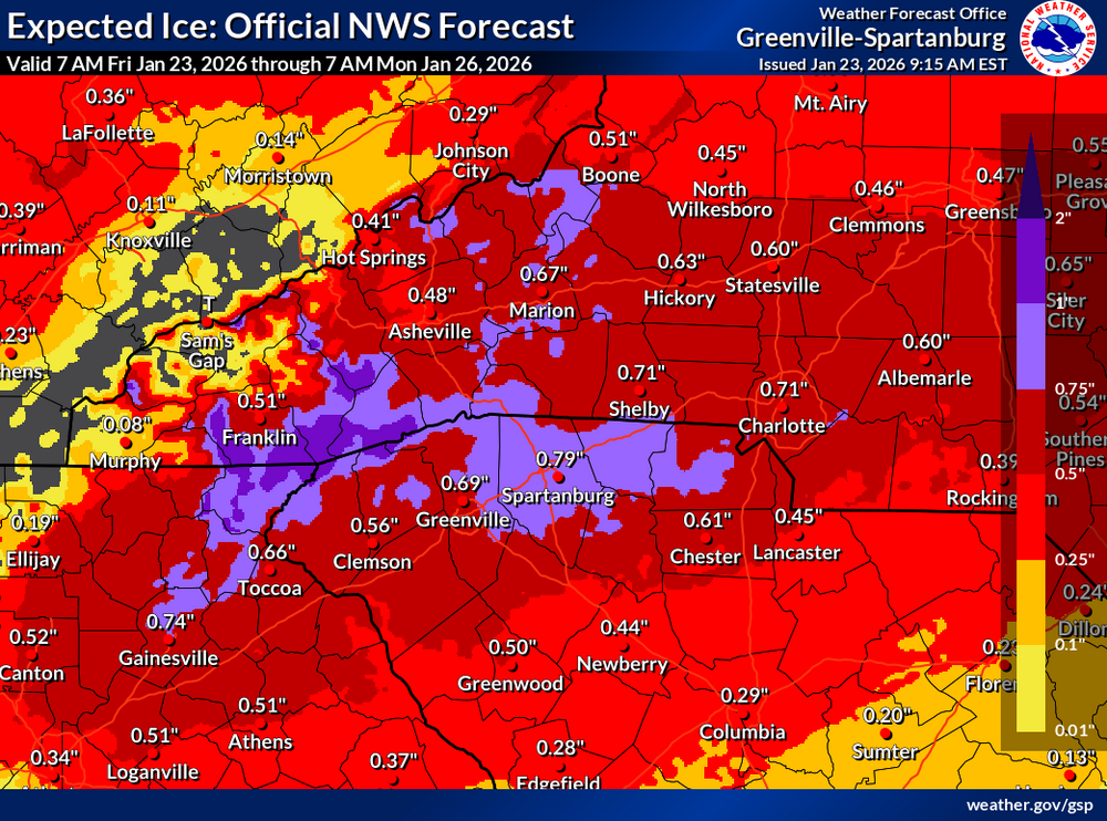
Latest from GSP. I am hopeful we get less precip looking at short range guidance
.thumb.png.7bdafa952b110809677c62c9afba26da.png)
-

Central PA Winter 25/26 Discussion and Obs
WmsptWx replied to MAG5035's topic in Upstate New York/Pennsylvania
When was the last time Greensburg got 20" of snow?


.png.5d17718591339a718ce86e089689db57.png)