All Activity
- Past hour
-
What did Parkton Mesonet report? I see it has 2.8” snow depth. There was decent melting yesterday in sunny spots so not sure how much had melted to know new snow depth
-

Rise of the Machines: January 18-19 Winter Storm Obs Thread
Sey-Mour Snow replied to WxWatcher007's topic in New England
Had a feeling that would happen -
We're in a pretty good band now, Larry. Front yard went from wet to white in about 10 minutes. I'd call it a heavy snow. Which gives me, a light heart
-
I am not even sure if we will see any flakes here nevermind accumulation.
-
This really might just be a full rainstorm here, with a coat of slop to finish. What a rug pull down here.
-
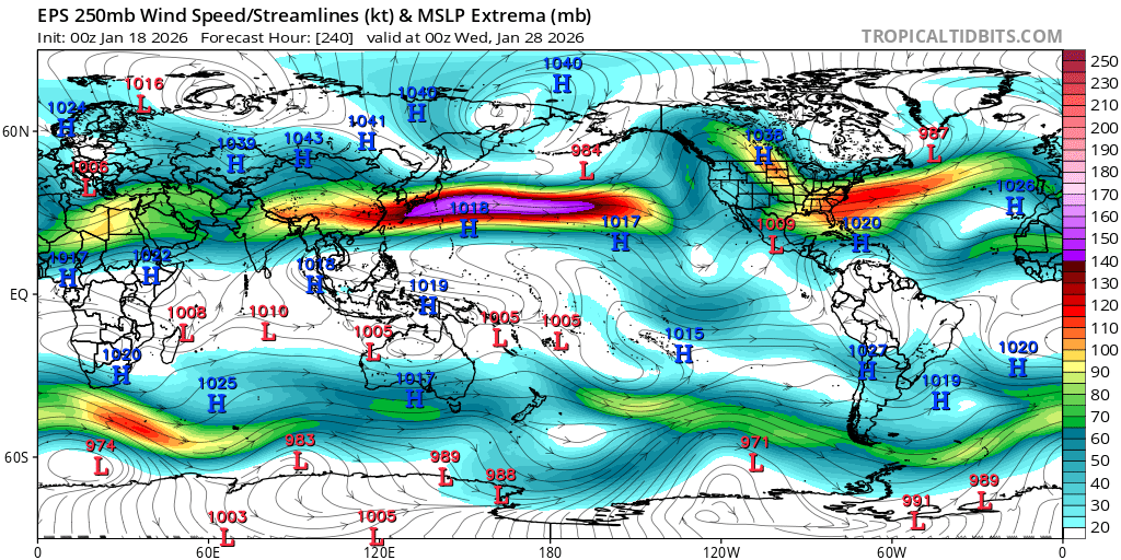
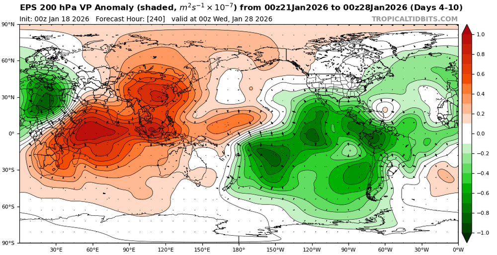
Yeah, phase 8 would help to activate the STJ. Notice the forcing shifting east of the Dateline later in January. The only question is whether we will be able to realize the potential. Need all the pieces to come together just right.
-

Rise of the Machines: January 18-19 Winter Storm Obs Thread
Kitz Craver replied to WxWatcher007's topic in New England
No radar returns over my house yet I’m in pondmetown, interesting indeed -
Looks like a nice event shaping up for you guys. Enjoy! I’ll be back on Wed night.
-
6z Euro definitely already showing what would lead to a snowier outcome down the road IMO compared to 00z. Less roughing in the northwest US, more press of the trough over the north and eastern US and the digging shortwave over southwest US. All looked better.
-

January 2026 regional war/obs/disco thread
jbenedet replied to Baroclinic Zone's topic in New England
Good thing having the snow cover around before that serious freeze next weekend…Oof. Insulate the basement/pipes and protect the plant roots… -

January 2026 Medium/Long Range Discussion
SomeguyfromTakomaPark replied to snowfan's topic in Mid Atlantic
Bee discussed but 0z eps looks fantastic for next weekend. Looks to favor a clean snow event vs ice. -
Moderate snow 31 in brightwaters. Now I get to drive to Marist U. Yay!
-
If only that moisture took that NW job we'd be thumping right now. Maybe will see some flakes before it's out.
-
I had no expectations. Precip east of me now so unless it back builds later, it’s a half inch or so.
-

Rise of the Machines: January 18-19 Winter Storm Obs Thread
UnitedWx replied to WxWatcher007's topic in New England
Snow has started in Westfield -

Rise of the Machines: January 18-19 Winter Storm Obs Thread
Damage In Tolland replied to WxWatcher007's topic in New England
That picked up quickly. Nothing to steady snow -
Rise of the Machines: January 18-19 Winter Storm Obs Thread
CarverWX replied to WxWatcher007's topic in New England
Everything snow covered quickly -
Ive never seen so little snow screw up the thruway like this. Short manpower maybe?
-
GFS Snow. Euro Ice. Canadian Snow. Somewhere in that mix is the truth. Cold and windy also a possibility I suppose.
-
Radar indicates a heavy area of precip is aimed for just S of Macon (Warner Robbins southward) and then just E of Macon (Jeffersonville east)! Macon will be near NW border of this heavy precip. it appears.
-
Over an inch already!!
-

Central PA Winter 25/26 Discussion and Obs
Blizzard of 93 replied to MAG5035's topic in Upstate New York/Pennsylvania
Absolutely stunning out there with all of the trees plastered with snow. -

Rise of the Machines: January 18-19 Winter Storm Obs Thread
moneypitmike replied to WxWatcher007's topic in New England
It appears the band is right on the new house.......I might head down in a while to see how they do in round one. -

First Legit Storm Potential of the Season Upon Us
dryslot replied to 40/70 Benchmark's topic in New England
2" or so puts me at 40+" on the season. -
Rise of the Machines: January 18-19 Winter Storm Obs Thread
Kitz Craver replied to WxWatcher007's topic in New England
Wow snowing good now, street covered up


.thumb.jpeg.f5c6ba9d911ec96b3b124f8606aee58e.jpeg)