All Activity
- Past hour
-
yep there's a lag for sure-even in in the winter the saying goes "As the days lengthen the cold strengthens"
-

2026-2027 Strong/Super El Nino
TheClimateChanger replied to Stormchaserchuck1's topic in Weather Forecasting and Discussion
-
Not sure what losing sunlight has to do with anything, when our warmest days aren't until after the solstice. Make that same post on 12/21 about gaining sunlight then lol.
-
Looks like a dry fropa Pike N, huh
-
Might not hit 90 today here. 87 off a high of 89 and with dews lowering heat advisory is not needed.
-
93/68 at my station. Wind more westerly keeping the sea breeze at bay for now.
-

2026 Mid-Atlantic Severe Storm General Discussion
Eskimo Joe replied to Kmlwx's topic in Mid Atlantic
Split the difference and it's a standard Mid Atlantic Slight Risk™.- 365 replies
-
- 2
-

-
- severe
- thunderstorms
- (and 7 more)
-

2026 Mid-Atlantic Severe Storm General Discussion
Ellinwood replied to Kmlwx's topic in Mid Atlantic
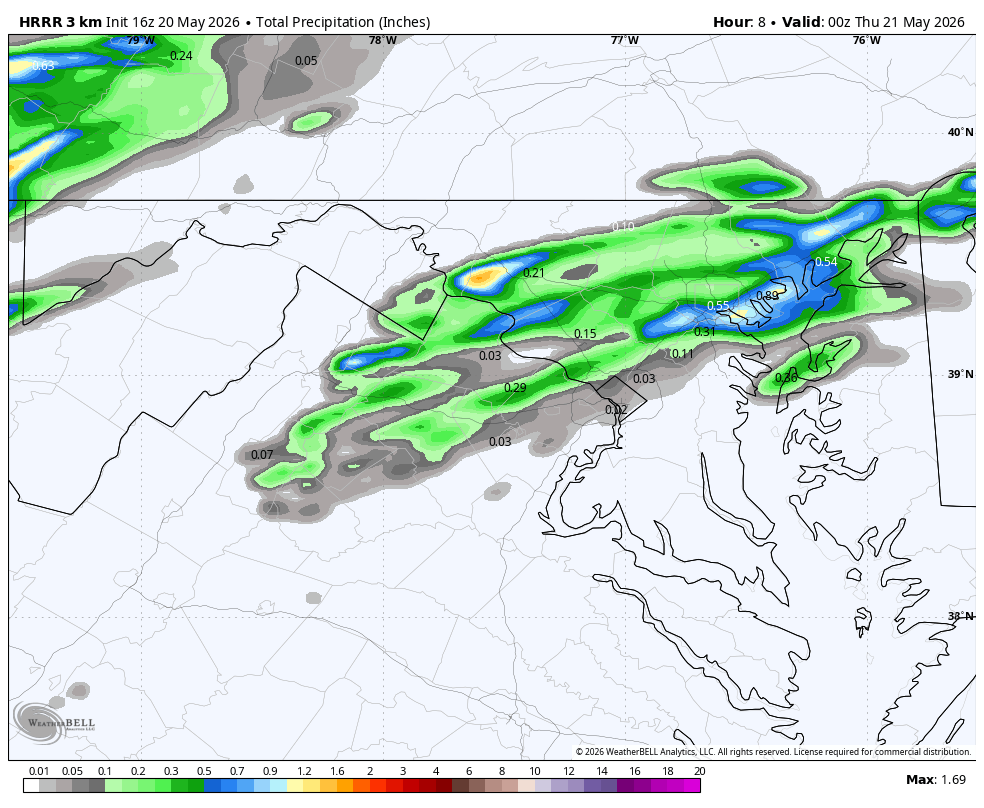
Not sure I'd be using the HRRR much today given it mixes out the low-levels too much and will be too low on dews by several degrees. Meanwhile, latest HRRR for 1pm vs radar: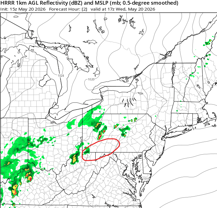
- 365 replies
-
- 3
-
-
- severe
- thunderstorms
- (and 7 more)
-
92/68 now, sea breeze moving back and fourth but it's roasting out there
-

2026 Mid-Atlantic Severe Storm General Discussion
MN Transplant replied to Kmlwx's topic in Mid Atlantic
Per usual, the HRRR is tracking too low on DPs and the NAM is too high.- 365 replies
-
- 1
-
-
- severe
- thunderstorms
- (and 7 more)
-

Central PA Spring 2026 Discussion/Obs Thread
Itstrainingtime replied to Voyager's topic in Upstate New York/Pennsylvania
Watches have been hoisted for just about all of us. -
Severe Thunderstorm Watch area wide until 8pm. WB 16Z HRRR thru 8pm.

-

2026-2027 Strong/Super El Nino
Stormchaserchuck1 replied to Stormchaserchuck1's topic in Weather Forecasting and Discussion
1997 had a +EPO Winter.. the 500mb was -30dm mean for Alaska, when in all Nino 3.4 the correlation is 0.0. I can't stress enough that +epo is the worst pattern for Winter weather in the Mid Atlantic and NE. 01-02 was the most +EPO Winter. Point is, +EPO is not really an El Nino pattern, even east based events have a mean of -5dm over Alaska. El Nino is more PNA and NPH. So some other factors caused some of the extreme, persistent warmth in 97-98, by lifting that trough north over Alaska and to the arctic circle. I still see the SSTA of this event as evolving much further west than that one though. Global warming has made it like 5x more likely to have something close to a 97-98 Winter now, especially without having mid latitude troughs which is usually a feature of el nino, but that doesn't mean we will see +EPO dominated the whole cold season. -
SEVERE THUNDERSTORM WATCH OUTLINE UPDATE FOR WS 234 NWS STORM PREDICTION CENTER NORMAN OK 1240 PM EDT WED MAY 20 2026 SEVERE THUNDERSTORM WATCH 234 IS IN EFFECT UNTIL 800 PM EDT FOR THE FOLLOWING LOCATIONS MDC001-003-005-013-015-021-023-025-027-031-033-043-510-210000- /O.NEW.KWNS.SV.A.0234.260520T1640Z-260521T0000Z/ MD . MARYLAND COUNTIES INCLUDED ARE ALLEGANY ANNE ARUNDEL BALTIMORE CARROLL CECIL FREDERICK GARRETT HARFORD HOWARD MONTGOMERY PRINCE GEORGES WASHINGTON MARYLAND INDEPENDENT CITIES INCLUDED ARE BALTIMORE CITY $$ SEVERE THUNDERSTORM WATCH OUTLINE UPDATE FOR WS 234 NWS STORM PREDICTION CENTER NORMAN OK 1240 PM EDT WED MAY 20 2026 SEVERE THUNDERSTORM WATCH 234 IS IN EFFECT UNTIL 800 PM EDT FOR THE FOLLOWING LOCATIONS VAC013-043-047-059-061-069-079-107-113-139-153-157-165-171-187- 510-600-610-660-683-685-840-210000- /O.NEW.KWNS.SV.A.0234.260520T1640Z-260521T0000Z/ VA . VIRGINIA COUNTIES INCLUDED ARE ARLINGTON CLARKE CULPEPER FAIRFAX FAUQUIER FREDERICK GREENE LOUDOUN MADISON PAGE PRINCE WILLIAM RAPPAHANNOCK ROCKINGHAM SHENANDOAH WARREN VIRGINIA INDEPENDENT CITIES INCLUDED ARE ALEXANDRIA FAIRFAX FALLS CHURCH HARRISONBURG MANASSAS MANASSAS PARK WINCHESTER $$ SEVERE THUNDERSTORM WATCH OUTLINE UPDATE FOR WS 234 NWS STORM PREDICTION CENTER NORMAN OK 1240 PM EDT WED MAY 20 2026 SEVERE THUNDERSTORM WATCH 234 IS IN EFFECT UNTIL 800 PM EDT FOR THE FOLLOWING LOCATIONS WVC003-023-027-031-037-057-065-071-210000- /O.NEW.KWNS.SV.A.0234.260520T1640Z-260521T0000Z/ WV . WEST VIRGINIA COUNTIES INCLUDED ARE BERKELEY GRANT HAMPSHIRE HARDY JEFFERSON MINERAL MORGAN PENDLETON $$
-
WWUS from KWNS Watch issued Mid -Atlantic south of here
-
2026 Mid-Atlantic Severe Storm General Discussion
Eskimo Joe replied to Kmlwx's topic in Mid Atlantic
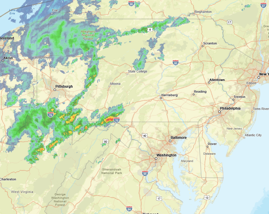
Latest HRRR is essentially a bust. Some hit or miss storms, but nothing that would amount to more than half an inch of rain, and certainly not severe. -
That was fast... watch up until 8pm
-

2026 Mid-Atlantic Severe Storm General Discussion
high risk replied to Kmlwx's topic in Mid Atlantic
Definitely consistent with the idea that this is mainly a threat north of 66 (VA) 50 (MD). -
Good. Bake out Mt. Washington so I can hit some 370 yd drives again.
-
https://www.spc.noaa.gov/products/md/md0801.html Mesoscale Discussion 0801 NWS Storm Prediction Center Norman OK 1123 AM CDT Wed May 20 2026 Areas affected...portions of the Mid-Atlantic Concerning...Severe potential...Severe Thunderstorm Watch likely Valid 201623Z - 201800Z Probability of Watch Issuance...80 percent SUMMARY...Widely scattered thunderstorms will pose a risk for damaging wind gusts and isolated large hail this afternoon and evening. A Severe Thunderstorm Watch will be needed soon. DISCUSSION...Latest surface observations depict a cold front extending from central New York southwestward through north-central and western Pennsylvania into southeast Ohio. Ahead of this cold front, temperatures are warming into the 90s across portions of the Mid-Atlantic, with surface dewpoints in the low/mid 60s F. Continued heating of this air mass is supporting 1000-1500 J/kg MLCAPE, with further destabilization anticipated through the afternoon hours. Recent satellite/radar imagery has shown increasing convective coverage ahead of the aforementioned cold front as remaining inhibition is eroded. With stronger mid/upper-level flow remaining displaced to the northwest, only modest effective shear is analyzed across the region (generally 20-30+ kts per latest mesoanalysis). This will be sufficient to support updraft organization with multicells, and perhaps marginal supercells, likely. Steep low-level lapse rates, well-mixed boundary layer profiles, and surface dewpoint depressions exceeding 20-25 F will promote the potential for damaging wind gusts, particularly with any more organized clusters that develop. Isolated instances of large hail may also accompany any more robust updrafts despite weak mid-level lapse rates (as sampled by the 12z PIT/IAD observed soundings). A Severe Thunderstorm Watch will be needed soon. ..Chalmers/Hart.. 05/20/2026 ...Please see www.spc.noaa.gov for graphic product... ATTN...WFO...PHI...BGM...CTP...LWX...PBZ...RLX... LAT...LON 40687798 40987676 40987614 40907587 40747568 40397553 39967560 39437589 39147621 38927665 38687793 38597862 38587907 38767959 39117993 39388003 39737992 40107959 40247926 40687798 MOST PROBABLE PEAK WIND GUST...55-70 MPH MOST PROBABLE PEAK HAIL SIZE...1.00-1.75 IN
-
SWO from KWNS Severe Watch needed soon in Mid-Atlantic
-
STW coming soon for majority of LWX CWA
-
meh-everything will be wet and waterlogged with overcast damp conditions. Monday is our only hope really for anything serviceable.
-

2026 Mid-Atlantic Severe Storm General Discussion
batmanbrad replied to Kmlwx's topic in Mid Atlantic
alerted on Radarscope of an MCD issued for our area, 80% chance of a blue box coming. -
you should be good...timing for anything there is after 4-5 PM...probably more towards 5-7