
All Activity
- Past hour
-

Augdewst 2026: Summer's Last Stand
vortex95 replied to Prismshine Productions's topic in New England
I know "soaking" is subjective, but generally I think "1-2" widespread" is a good min criteria. Although definitions are fluid here b/c of the use of "STEIN!" -
 Buy Tadalafil 20mg [url=https://securemedonline.com/#]SecureMed Online[/url] Tadalafil price
 -
ed treatment online: GlobalCare Pharmacy - how to get ed meds online
-

Augdewst 2026: Summer's Last Stand
dendrite replied to Prismshine Productions's topic in New England
Man what a day…kinda warm out there in the sun. CON 81 -

Augdewst 2026: Summer's Last Stand
WxWatcher007 replied to Prismshine Productions's topic in New England
Strong signal for a vigorous wave over the MDR in a few days, but we’ll need to see if shear can relent enough to allow for gradual development. -
1st warmest (30 day average)
-
Regarding the AEW progged to come off Africa 8/24-5, the 12Z GFS/Euro AI are weak, especially Euro, and have it go in or near the Leewards Aug 31st. The reg. Euro has had this as a TC since way back on the 12Z 8/15 run. The 12Z Euro has it, but early on it is the weakest run for it well out in the MDR since 0Z 8/17 run. Keep in mind, however, that weaker could ultimately prove more dangerous for the W basin nearby land areas as strong runs have mostly been recurving safely as regards the Conus. Note that late in the run it is pretty far W (73W) and actually strengthens into a MH as it recurves not too far from the E coast. The model consensus has this moving at 20+ mph WNW in the MDR to the SSW of a strong E ATL high. That may be a reason models are keeping this rather weak out in that area. This is still not on the TWO. But they may change soon.
-

2026-2027 Record-breaking El Nino
Brian5671 replied to Stormchaserchuck1's topic in Weather Forecasting and Discussion
same ol shtick year after year... -
Some peaks try to break through but otherwise a gunky day.
-
I'm getting it from WeatherBell
-

Augdewst 2026: Summer's Last Stand
SouthCoastMA replied to Prismshine Productions's topic in New England
.30" in 18 hours - just a brutal day and not much to show for it -
No water restrictions being lifted anytime soon for Catawba Valley residents. The one metric that’s holding us back is the 6 month streamflow average. Seems like a flawed metric imo. The 6 month average is going to be harshly skewed by the streamflow at the height of the drought so it seems like it may be the first of next year before restrictions are lifted despite whatever fall brings.
-

2026-2027 Record-breaking El Nino
mitchnick replied to Stormchaserchuck1's topic in Weather Forecasting and Discussion
Where? What period? F or C? Snowfall forecast? Not that details matter in a weather forecast. -
I don't have the 12z Euro on weather.cod.edu. Are you getting it from a paid site?
-

Augdewst 2026: Summer's Last Stand
ineedsnow replied to Prismshine Productions's topic in New England
So far out but the 12z EURO might have been interesting if it went out a bit more -

2026-2027 Record-breaking El Nino
LakePaste25 replied to Stormchaserchuck1's topic in Weather Forecasting and Discussion
W Pac has really been cooling down.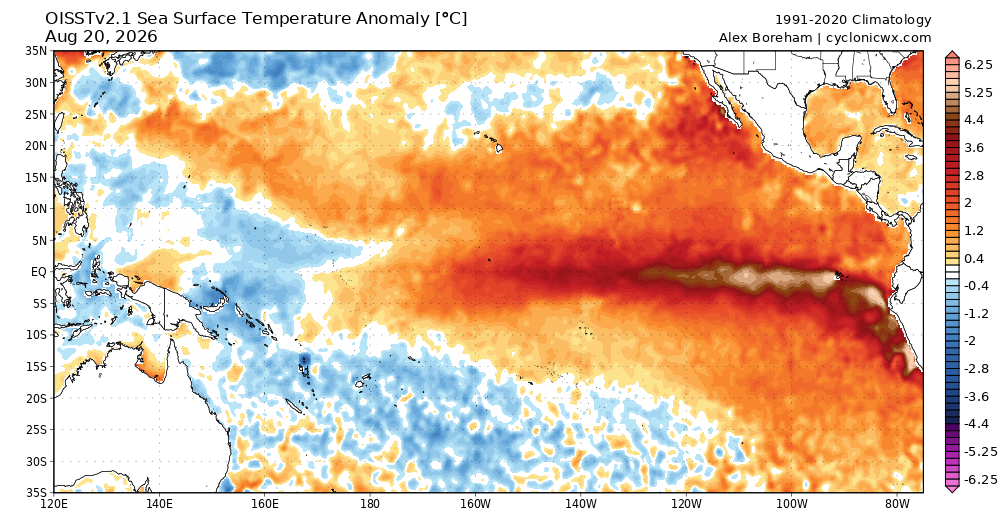
-
The 06z Euro gave Augusta County 1.05" by Sat. at 12z. At 12z it came to its senses with .10". The Euro has degraded to Graf league.
-

2026 Mid-Atlantic Severe Storm General Discussion
Eskimo Joe replied to Kmlwx's topic in Mid Atlantic
Preliminary damage points from the York County tornado indicate EF-2 -
That sounds right.
-
Count it.
-
Soooooo dry here. Less than an inch recorded here this month so far. Hopefully we get one of these storms popping up to get us some rain.
-
-
Thanks, pretty cool. I never knew about the sheep. One thing they didn't mention, if you notice a wall with lots of smaller rocks it was most likely used for cultivation. Farmers wouldn't bother for grazing.
-
Uggg...this cloud cover. We can never catch a break. Just a trace yesterday and lastnight.












