All Activity
- Past hour
-

E PA/NJ/DE Summer 2026 Obs/Discussion
BBasile replied to PhiEaglesfan712's topic in Philadelphia Region
Mountains, snow, high plains supercells with large hail and tornadoes. Yep, I'm jealous! -
 https://tadaliko.shop/# Generic Cialis price
 -
-
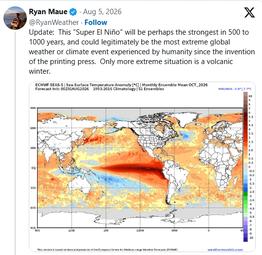
I don't understand on how he can can be so confident in below average temps throughout the NE in the most intense El Nino on record when there is no incidence of the NE being below average in an intense El Nino in recorded history. He said that he would explain early on, but never really did....just offered some vague rhetoric concerning +PNA inducing backdoor arctic shots. Arctic infiltration from the north is the most efficient avenue for arctic deliver in the NE, which was evident in the Feb 2016 outbreak, however, it is highly unlikely to be prevalent enough to be reflected in the seasonal mean.
-
https://x.com/PettusWX/status/2085091579224555843 James Pettus @PettusWX 16h Classic summertime feel with our upcoming pattern late this week into next week. 500mb flow will keep things active in the northeast quadrant of the CONUS with multiple storm and severe weather chances. Most if not all of which will be mainly damaging wind threats. Generally most of the eastern half of the CONUS will have isolated summertime storm chances with a few severe chances perhaps mixed in. Out west, mostly dry with isolated rain chances continuing in and around Arizona. Unfortunately, it looks like our wildfire risk will persist. As always, stay tuned to your local NWS office for day by day official forecasts.
-

Augdewst 2026: Summer's Last Stand
jlauderdal replied to Prismshine Productions's topic in New England
Floridews on that map, swampy today -
Records: Highs: EWR: 97 (2001) NYC: 97 (1955) LGA: 95 (2018) JFK: 91 (2010) Lows: EWR: 57 (1934) NYC: 56 (1869) LGA: 57 (1994) JFK: 57 (1994) Historical: 1881: Smoke from Michigan forest fires created a yellow pall over the Northeast. Candles were necessary for light at noontime. (Ref. AccWeather Weather History) 1890 - Thunderstorms left four inches of hail covering the ground in Adair County and Union County in Iowa. The hail drifted into six foot mounds, and in some places remained on the ground for twenty- six days. (The Weather Channel) 1905: Princeton, IN received 10.50 inches of rain, which established a 24-hour maximum precipitation record for the Hoosier State. (Ref. Wilson Wx. History) 1918 - Unusually hot weather began to overspread the Atlantic Coast States, from the Carolinas to southern New England. The temp- erature soared to an all-time record high of 106 degrees at Washington D.C., and Cumberland and Keedysville hit 109 degrees to establish a state record for Maryland. Temperatures were above normal east of the Rockies that month, with readings much above normal in the Lower Missouri Valley. Omaha NE reached 110 degrees. (David Ludlum) On this date the highest ever maximum temperature of 107 °F was recorded in Richmond, VA. (Ref. Richmond Weather Records) 1947: The city, Sault Ste. Marie, MI hit 98°, equaling their all-time highest temperature. (Ref. AccWeather Weather History) 1959 - A bucket survey showed that thunderstorms dropped 16.70 inches of rain on parts of Decatur County IA. The total was accepted as Iowa's 24 hour rainfall record. (The Weather Channel) 1959: Hurricane Dot crossed Kauai in the Hawaiian Islands producing sustained winds of 105 mph with gusts to 125 mph. Over 6 inches of rain fell with over 9 inches on the big island of Hawaii. The sugar cane crop on Kauai sustained $2.7 million in damages. 1961: A severe thunderstorm brought 70 to 100 mph winds to Lake Texoma, OK. The winds caused extensive damage to piers and either damaged or sank more than 100 boats. One person drowned when their boat capsized during the storm. (Ref. Wilson Wx. History) 1977: Severe thunderstorms produced nearly 20 tornadoes in Sangamon and Christian Counties in central Illinois. Many of these only affected open fields. However, one tornado did cause extensive damage near and east of Chatham. One tornado just south of Lake Springfield was unusual in that it had a clockwise rotation, in contrast to the usual counter-clockwise rotation found in tornadoes. The thunderstorms that produced these tornadoes caused a large swath of destruction from strong winds extending from southwestern Morgan County east to far southwestern Macon County. (Ref. Wilson Wx. History) 1979: 100° at Salt Lake City, UT tied the record for the date. It was the 5th day of temperatures 100° or hotter. (Ref. AccWeather Weather History) 1986 - Evening thunderstorms produced wind gusts to 100 mph at Winner SD damaging two hundred homes. (The National Weather Summary) (Storm Data) 1987 - Afternoon thunderstorms deluged Milwaukee, WI, with 6.84 inches of rain, including more than five inches in two hours, breaking all previous rainfall records for the city. Floodwaters were four feet deep at the Milwaukee County Stadium, and floodwaters filled the basement of the main terminal at the airport. Flooding caused 5.9 million dollars damage, and claimed the life of one person. Death Valley, CA, reported a morning low of 97 degrees. A midday thunderstorm deluged Birmingham AL with nearly six inches of rain in one hour. (The National Weather Summary) (Storm Data) 1988 - Severe thunderstorms produced large hail and damaging winds in Pennsylvania and New York State. A cold front crossing the northwestern U.S. produced wind gusts to 66 mph at Livingston MT. (The National Weather Summary) (Storm Data) 1989 - Thunderstorms developing ahead of a cold front produced severe weather from northwestern Texas to the Southern Appalachians, and in the northeastern U.S. There were 136 reports of large hail or damaging winds during the day and evening. Thunderstorms in the Southern Plains Region produced tennis ball size hail northwest of Buffalo OK, and wind gusts to 100 mph at Pampa TX. (Storm Data) (The National Weather Summary) 1992: A firefighter was knocked unconscious in Sarasota County, Florida struck by lightning while fighting a fire that was caused by a lightning strike. (Ref. AccWeather Weather History) 1993: Virginia experienced its worst tornado outbreak ever as 18 tornadoes ripped through the state in 5 hours. The most devastating tornado caused severe damage in the historic part of Petersburg. The storm then moved on to Pocahontas Island and into Colonial Heights. There, the storm ripped apart a WalMart store, killing three people and injuring nearly 200. The F4 twister was the first known violent tornado in Virginia history. It killed a total of 4 people and injured 246 along its 12-mile path. Total damages were near $50 million. 2001: Tropical Storm Barry moved inland on the Gulf Coast near Fort Walton Beach, FL around midnight with top winds of 60 mph. The storm caused $30 million in damage. Heavy rains spread northwestward across Alabama with up to three inches reported in the Birmingham area. No precipitation fell at Billings, MT on this date, the first of an August record 22 consecutive days without even a trace of rain. Only 0.01 inches fell during the month, their record driest August. (Ref. Wilson Wx. History) 2003: Dallas-Fort Worth, Texas: Temperatures soar to 109°F at Dallas-Fort Worth International Airport, surpassing the old record set in 1952. (Ref. WxDoctor) 2005: A camper was slightly injured when a lightning struck a nearby tree at a campground at Lake Robertson, near Collierstown in Rockbridge County, VA. (Ref. Lightning - Virginia Weather History)
-
78 - DP: 77. Current clouds over C/N - NJ but should clear out. Hot/Humid with Florida style storms today - Tuesday. The humid flow around the Atlantic ridge hugging the EC and the potential for 6 days at 90+. FRont comes through by Wed and a trough into the northeast 8/12 - 8/15 but still need to see if we're near normal or still warm. Overall warmer pattern beyond there.
-
Hideous outside. My front door was soaking wet this morning and it resembles a jungle outside.
-
Well...
-

Augdewst 2026: Summer's Last Stand
CoastalWx replied to Prismshine Productions's topic in New England
Should bust out later this morning. Tomrrow could feature sct storms that could be potent. Not a lot of shear but high dews and decent CAPE. -

2026-2027 Record-breaking El Nino
40/70 Benchmark replied to Stormchaserchuck1's topic in Weather Forecasting and Discussion
2023 was pretty out of sync from a solar perspective, though, so I do think there was some resistance that may not be readily apparent. This year we have the massive, unprecedented OHC working in conjunction with the favorable descent of solar cycle 25....perfect storm, so to speak. This connection between descending solar and intense El Niño can be explained by the same "bottom up" theory that research originally incorrectly applied to the supposed link between solar max and +NAO, which has since been debunked by more modern work. Here is a schematic explaining why La Nina is favored during high solar, as was the case last winter. Obviously, the inverse is true during descending solar, as is the case currently. More clouds leads to less evaporation and warmer sea surface temperatures, which results in weaker trades with stronger WWBs carrying moisture and warmer waters to the west. This weakens the Walker Cell, leading to stronger MC subsidence in the west, which reduces tropical convection. The descending portion of solar cycle 25 has been met with the highest OHC in recorded history throughout the Pacific basin, hence we are seeing the strongest El Nino in recorded history materialize. -
Augdewst 2026: Summer's Last Stand
CoastalWx replied to Prismshine Productions's topic in New England
Cloud base is not typical of marine layer. At least here. Jsut stubborn warm front dews. -
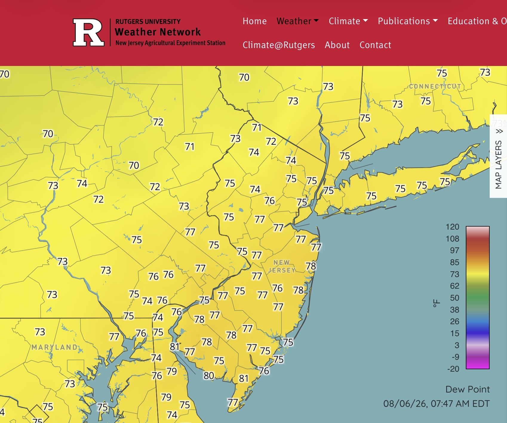
80 degree dewpoints holy cow
-
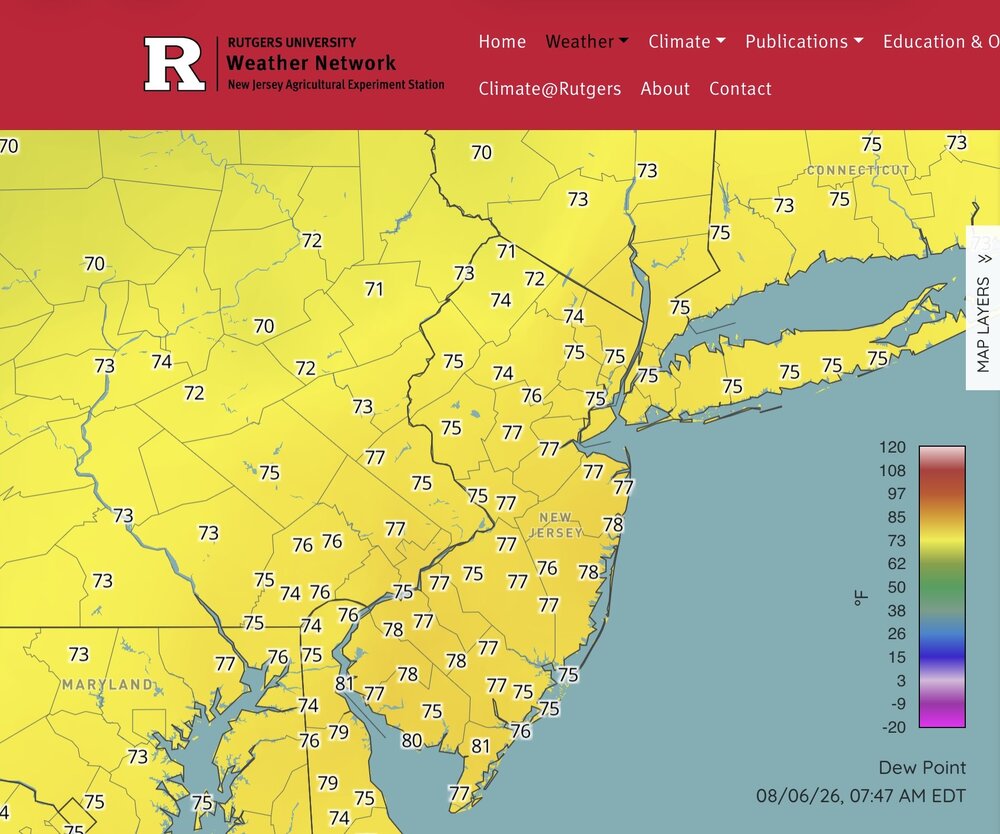
The Florida dew points have arrived with values around 80° in SNJ.
-
п»їcialis generic Tadaliko - Tadaliko
-

Augdewst 2026: Summer's Last Stand
SouthCoastMA replied to Prismshine Productions's topic in New England
marine layer stratus holding strong. maybe some afternoon sun? -

Augdewst 2026: Summer's Last Stand
HoarfrostHubb replied to Prismshine Productions's topic in New England
Yeah. We had a trace at some point. Some thin fog. Dews back with a vengeance -

Central PA Summer 2026 Discussion/Obs Thread
pawatch replied to Voyager's topic in Upstate New York/Pennsylvania
72 degrees this morning. .01” of rain overnight. -
Soupy already this morning
-

2026-2027 Record-breaking El Nino
bluewave replied to Stormchaserchuck1's topic in Weather Forecasting and Discussion
We had a massive OHC build up prior to 2023-2024. But the WWBs were mostly focused near South America. They were much weaker where they are currently record breaking now. The one change this time was the record WWB and general pattern at the start of the process last November into December associated with tropical cyclone Senyar was really extreme. -

Augdewst 2026: Summer's Last Stand
dendrite replied to Prismshine Productions's topic in New England
Love love me dews you know I love dews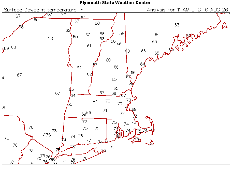
-

2026-2027 Record-breaking El Nino
GaWx replied to Stormchaserchuck1's topic in Weather Forecasting and Discussion
I know this Nino is headed toward 175 year record obliterating status. Be that as it may, is Maue being just a bit overly-dramatic for clicks/likes? It sounds so dramatic that it sounds like sarcasm: He originally said this way back in April: https://www.tribuneindia.com/news/weather-report/weather-expert-warns-this-years-mega-el-nino-could-be-strongest-since-1877/amp -
2026-2027 Record-breaking El Nino
40/70 Benchmark replied to Stormchaserchuck1's topic in Weather Forecasting and Discussion
I'm quite confident that it's related to the massive amount of OHC that has built up in the western Pacific basin. -
Same here. Lots of lighting and loud thunder. No wind. Torrential rain. Picked up 1.01" in about 15-20 minutes. Sauna like out there this morning.