All Activity
- Past hour
-
Upper 20's/low 30's around the area this morning with a band of snow shwrs to my NE.
-
Yeah just light showers here. Better than nothing I suppose
-
Some excellent moisture for the area, especially the mountains. Hopefully that keeps the edge off fire season.
-
Latest GFS still showing 2 plus inches for the CLT metro by Friday. Cant believe its this close and not falling apart lol
-
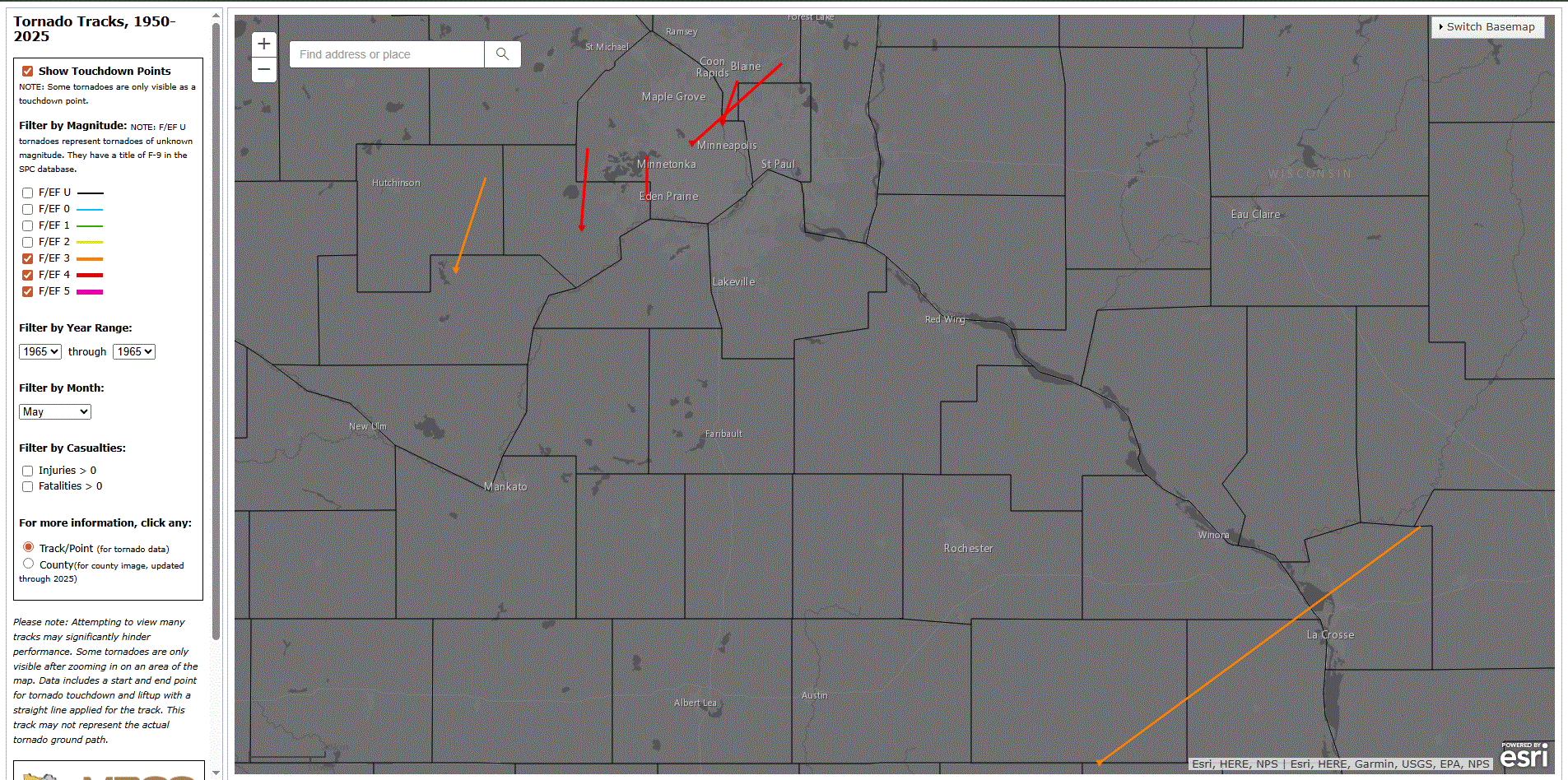
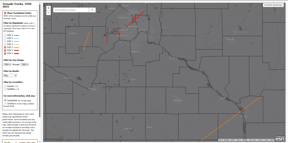
May 6 1965: 6 strong tornadoes, 4 of which were rated F4 on the Fujita Scale, devastate parts of east central Minnesota, including parts of the Twin Cities metro area. 14 people are killed, and 683 are injured. 2 of the F4 tornadoes hit Fridley. For Wednesday, May 6, 2026 1933 - Charleston, SC, was deluged with 10.57 inches of rain, an all- time 24 hour record for that location. (The Weather Channel) 1975 - A massive tornado hit Omaha, NE, killing three persons, injuring 133 others, and causing 150 million dollars damage. The tornado struck during the late afternoon moving northeastward through the industrial and residential areas of west central Omaha, and lifting over the northern section of the city. The twister, which cut a swath ten miles long and as much as a quarter of a mile wide, was the mostly costly in U.S. history up till that time. (David Ludlum) 1987 - Eighteen cities in California and Oregon reported record high temperatures for the date. Highs of 91 degrees at Portland OR, 101 degrees at Medford OR, and 104 degrees at Sacramento CA, were the warmest of record for so early in the season. (The National Weather Summary) 1988 - A major storm brought high winds to the western half of the country. A wind gust of 74 mph at Pueblo CO broke their May record established just four days earlier, and winds in the Arapahoe Ski Basin area of Colorado reached 85 mph. In North Dakota, the high winds reduced visibilities to near zero in blowing dust closing many roads. (The National Weather Summary) (Storm Data) 1989 - Sixteen cities in the north central U.S. reported record low temperatures for the date. Morning lows of 17 at Bismarck ND and 26 at Minneapolis MN were the coldest of record for so late in the season. A reading of 43 degrees at the start of the Kentucky Derby was the coldest in 115 years of records. Light snow was reported in the Upper Midwest, with an inch reported at Chicago IL. (The National Weather Summary) 1990 - Snow and high winds prevailed behind a Pacific cold front crossing the northwestern U.S. Wind gusts above 50 mph were reported in southeastern Idaho, and heavy snow blanketed the Cascade Mountains of Washington State, with twelve inches reported at Stampede Pass. (The National Weather Summary) NOTE: NWS MSP write up on the 1965 tornado outbreak https://www.weather.gov/mpx/60thAnnivesaryofMay06_1965_Tornados Screenshot of the event from MRCC Tornado tracking tool.
-
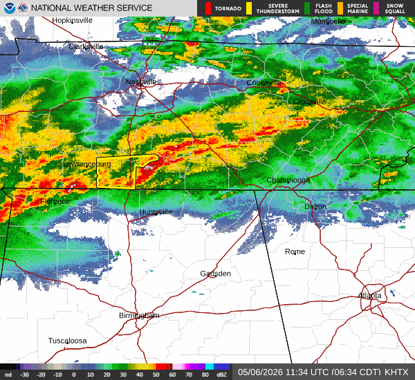
Yellow-with-dots-of-red area in Fairfax County came out of nowhere on radar; an hour ago it looked like light rain with a gap to the SW.
-
Looks like from about Haywood south is going to get a good wollup today and tonight. Better buckle up.
-

Central PA Spring 2026 Discussion/Obs Thread
Itstrainingtime replied to Voyager's topic in Upstate New York/Pennsylvania
What's interesting about the timing is CTP has almost all of under "likely" (60-90% POPs) of rain right through the evening hours. Yet Mount Holly has the Delaware Valley free of rain by 4pm despite being farther east. I don't know if more stuff is going to come through later, but the "main" batch of precip looks to be through here by early afternoon? -
-
After 3 swipes of the snowboard yesterday and today - final tally 19.5” here. Perhaps another inch coming this morning but it is winding down here. What a great storm.
-
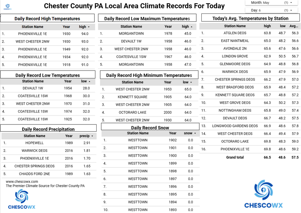
Records: Highs: EWR: 93 (1949) NYC: 92 (1986) LGA: 93 (1949) JFK: 88 (1986) Lows: EWR: 40 (1967) NYC: 32 (1891) LGA: 41 (1967) JFK: 37 (1992) Historical: 1840: The second deadliest tornado in U.S. history struck Natchez and Natchez Landing, MS, killing 317 people. (Ref. Wilson Wx. History) 1876: A tornado, estimated at F3 intensity, tracked four miles across Chicago, Illinois. The damaged buildings included a candy factory, a hospital, a freight depot, and a church. The tornado moved out over Lake Michigan and was observed to have multiple vortices by a reporter. Further south in Illinois, a tornado blew a moving passenger train off the tracks near Neoga, injuring all 19 people aboard. 1900: “The Day of the Cyclones”. A tornado moved south, passing five miles west of Jetmore, KS picking up a small home and smashing it to the ground, killing a woman. Cattle were carried 200 yards. At least 15, perhaps over 25, tornadoes touched down in Kansas this day. (Ref. Wilson Wx. History) 1911 : Record Minimum temperature for Washington, DC for the date is 37 °F. 1917: Amarillo, TX had its latest snowfall on record with 9.1 inches falling. 1933 - Charleston, SC, was deluged with 10.57 inches of rain, an all- time 24 hour record for that location. (The Weather Channel) 1937: The German passenger airship LZ 129 Hindenburg caught fire and was destroyed during its attempt to dock with its mooring mast at Naval Air Station Lakehurst in Manchester Township, New Jersey, United States. Of the 97 people on board (36 passengers and 61 crewmen), there were 35 fatalities (13 passengers and 22 crewmen). One worker on the ground was also killed, making a total of 36 deaths. The Hindenburg was delayed two hours from docking due to thunderstorms in the area. 1967: It was a busy Saturday night at the GES Department store near the Alabama State Fairgrounds in the West End section of Birmingham. The store was filled with shoppers about 7 PM when a store manager saw a tornado approaching. He yelled for customers to get down seconds before the twister struck the store. One woman was killed nearby when she was struck by a board from a nearby lumber yard as she watched the tornado from her daughter's front porch. 25 people were injured along the F2 tornado's four mile path. (Ref. Wilson Wx. History) 1975 - A massive tornado hit Omaha, NE, killing three persons, injuring 133 others, and causing 150 million dollars damage. The tornado struck during the late afternoon moving northeastward through the industrial and residential areas of west central Omaha, and lifting over the northern section of the city. The twister, which cut a swath ten miles long and as much as a quarter of a mile wide, was the mostly costly in U.S. history up til that time. (David Ludlum) 1978: Estes Park, County recorded 32 inches of snow, Boulder had 25 inches, 20 inches piled up at Colorado Springs, and Denver checked in with 14 inches for their greatest May snowstorm on record. Cheyenne, WY received 11.1 inches of snow and a total storm total of 18.3 inches; their greatest May snowstorm on record. (Ref. Wilson Wx. History) 1987 - Eighteen cities in California and Oregon reported record high temperatures for the date. Highs of 91 degrees at Portland OR, 101 degrees at Medford OR, and 104 degrees at Sacramento CA, were the warmest of record for so early in the season. (The National Weather Summary) 1988 - A major storm brought high winds to the western half of the country. A wind gust of 74 mph at Pueblo CO broke their May record established just four days earlier, and winds in the Arapahoe Ski Basin area of Colorado reached 85 mph. In North Dakota, the high winds reduced visibilities to near zero in blowing dust closing many roads. (The National Weather Summary) (Storm Data) 1989 - Sixteen cities in the north central U.S. reported record low temperatures for the date. Morning lows of 17 at Bismarck ND and 26 at Minneapolis MN were the coldest of record for so late in the season. A reading of 43 degrees at the start of the Kentucky Derby was the coldest in 115 years of records. Light snow was reported in the Upper Midwest, with an inch reported at Chicago IL. (The National Weather Summary) 1990 - Snow and high winds prevailed behind a Pacific cold front crossing the northwestern U.S. Wind gusts above 50 mph were reported in southeastern Idaho, and heavy snow blanketed the Cascade Mountains of Washington State, with twelve inches reported at Stampede Pass. (The National Weather Summary) 1999: Orlando, Florida: Double record day in Orlando. High temperature reaches 94 °F and late day cloudburst dumps short-period record rainfall of 1.21 inches of rain. (Ref. WxDoctor) 2001: The high temperature in Death Valley National Park, CA reached 100°. This began a record streak of 154 consecutive days with the high temperature reaching 100 degrees or hotter. (Ref. Wilson Wx. History)
-
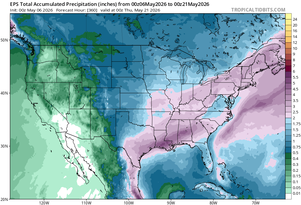
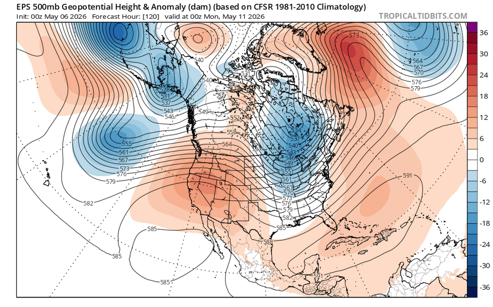
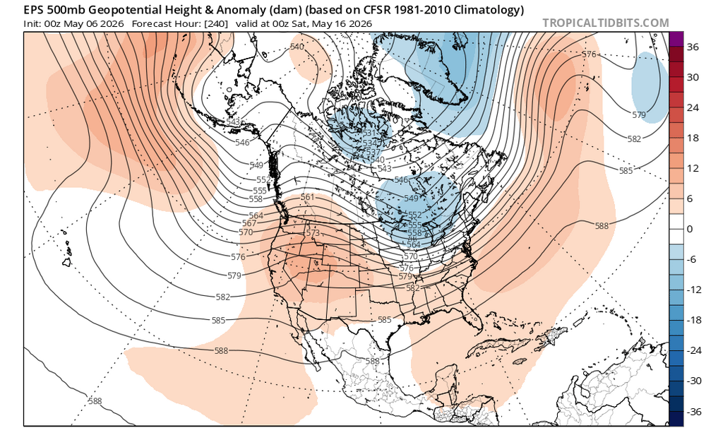
69 / 55 clouds / showers approaching from EPA. Looking like a general 0.25 or more for the area. Cooler Thu / Fri and perhaps a similar cloudy - showerish Saturday ahead of a one day Mothers Day warmup. Next week continues to look near / below normal with showers/rain on several days Mon - Fri. Still think we push towards a moderation by / after mid month with any shot at heat in the 5/17 - 5/24 window.
-
most of these rainy forecasts dont seem to pan out of late-look at today we'll be lucky to see .10 to maybe .25
- Today
-

2026 Spring/Summer Mountain Thread
Maggie Valley Steve replied to Buckethead's topic in Southeastern States
Light rain is falling over the Valley this morning. That radar looks very encouraging and I am hoping for an inch or two today and tonight! -
Really has continued to look like a widespread soaking is coming tonight/tomorrow. First time in forever it hasn’t collapsed up to this point. There’s still time to fail lol
-
(002).thumb.png.6e3d9d46bca5fe41aab7a74871dd8af8.png)
Central PA Spring 2026 Discussion/Obs Thread
ChescoWx replied to Voyager's topic in Upstate New York/Pennsylvania
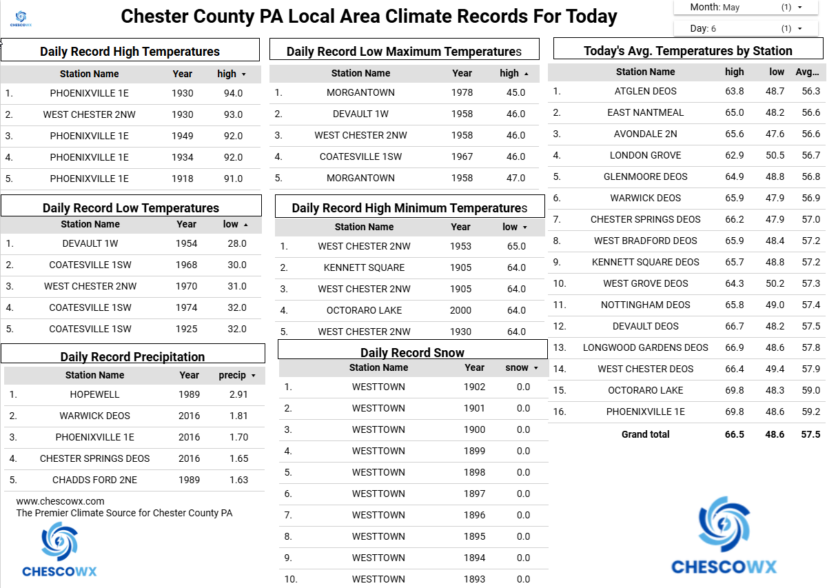
Cooler today with showers we could see up to 0.25" of needed rain. We are at 73% of normal rainfall for the year to date. We remain cooler than normal through Saturday with a brief warmup on Sunday to above normal before temperatures again fall below normal. Overall, the next couple weeks look to average below normal. Our next shower chances will be Saturday.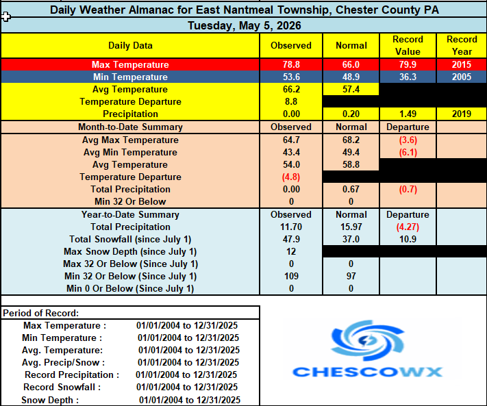
-
E PA/NJ/DE Spring 2026 Obs/Discussion
ChescoWx replied to PhiEaglesfan712's topic in Philadelphia Region
Cooler today with showers we could see up to 0.25" of needed rain. We are at 73% of normal rainfall for the year to date. We remain cooler than normal through Saturday with a brief warmup on Sunday to above normal before temperatures again fall below normal. Overall, the next couple weeks look to average below normal. Our next shower chances will be Saturday.
-
Interesting article ... scientists having pitted AI against SRES model systems. It inspires new research ideas for me where this could just be a start. But in so far as what it achieves, the basic finding is that AI is under-selling extreme events, performing demonstratively worse than standard physics-based SRES modelling - particularly with intensity handling. https://www.science.org/doi/10.1126/sciadv.aec1433
-
MSP got down to 32 this morning. Very likely our coldest morning until October.
-
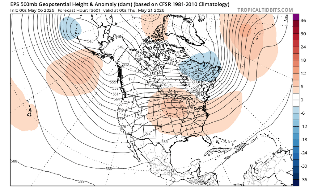
Yeah we cool first half and then hopefully heat and dews after 20th or so.
-
Nice little rain event this morning! Only 0.01" in gauge at 7 am, but close to 0.10" since then with light rain continuing to fall. Currently 57.3/54.0.
-
This looks really good. Sent from my SM-G998U using Tapatalk
-
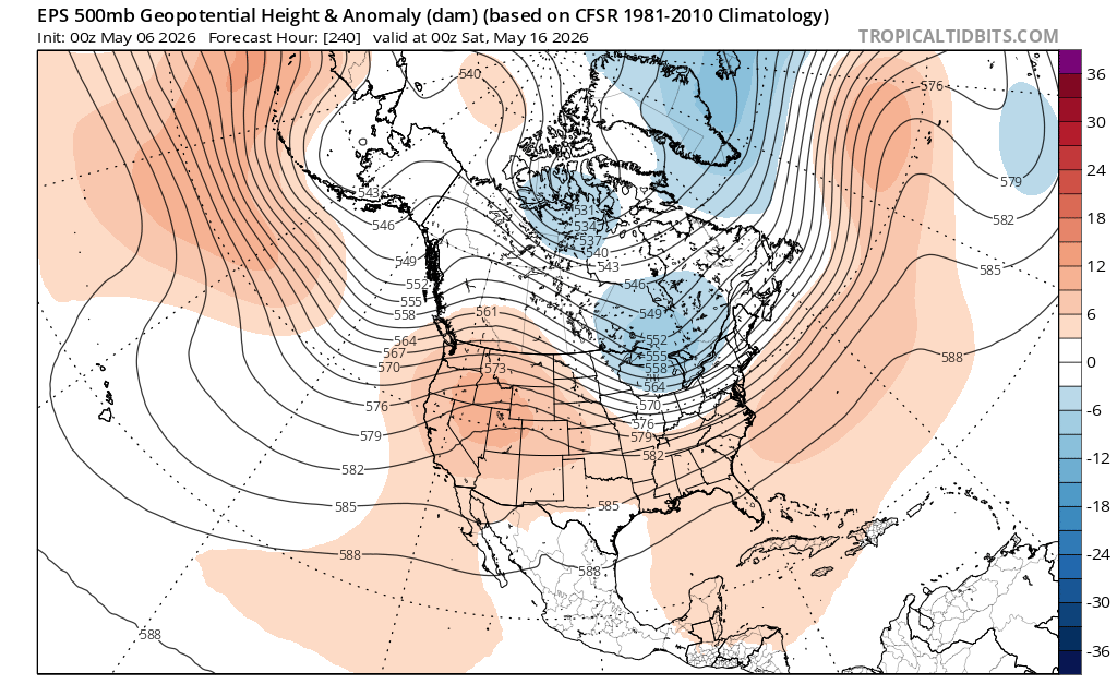
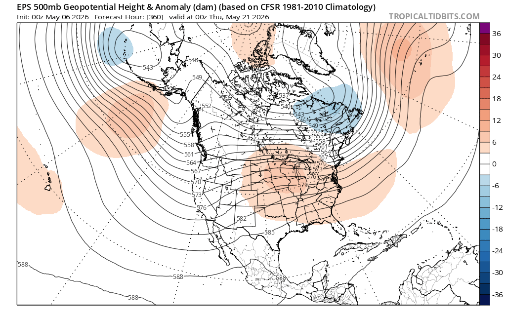
Looks like a fairly active pattern for cold fronts moving through from time to time. Main trough looks to be centered over the Great Lakes. It may continue to be the case that the NW winds behind the lows are more impressive than the actual rainfall totals. We’ll see… Perhaps as we approach late May the ridge out West can push into the Great Lakes and Northeast. But we would want to lose that 50/50 low to have a shot at some extended warmth like we had in March and April.
-
It almost feels like a snow day with how excited I am for rain tonight.