All Activity
- Past hour
-
Just got the chance to look at the 0z suite... Wow, there's your north trend and then some. Now that it seems increasingly possible you aim the intense WAA snows over the region, the entire evolution and storm is a bit different. I know the global models are showing a solid 18-24 hour storm, but from experience you usually only get 12-15 hours at most from a WAA thump until you dry slot. If I were to be super picky and extra HECS hunter, that would be what I'm not a fan of. But hey, if the Euro is right and you throw 1.25" QPF into an air mass with surface temps in the upper single digits and lower teens, as well with localized 850 fgen, easily crank out a few hours of 2-3" in/hr rates.
-

January 25/26 Jimbo Back Surgery Storm
NorthHillsWx replied to Jimbo!'s topic in Southeastern States
We have now crossed the line where the storm mode has changed. We won because energy was sliding under a 1040 mb high. This is now a super amped coastal. Even the big cities north of us are at risk of mix now if this is the case, like any nor Easter, BAM was right… That being said, be wary of the wedge eroding this fast, that’s a 1040, not a 1026 sitting in prime CAD position. EURO notoriously scours the wedge too quick. While hope for a snowstorm is fading and probably the least likely outcome for anyone on the board, I don’t see a way around a 2002-like ice event somewhere in the Carolina’s. Do not let your guard down, this can be a memorable storm, but for ALL the wrong reasons. What a freaking nightmare of a hobby -

MO/KS/AR/OK 2025-2026 Winter Discussion
JoMo replied to stormdragonwx's topic in Central/Western States
Winter Storm Watches now out for Southern KS and Southern MO. -

January 25/26 Jimbo Back Surgery Storm
LakeNormanStormin replied to Jimbo!'s topic in Southeastern States
NAM isn't great. But not terrible. Someone said look north of DFW. Sleet where we want snow. Not the trend the early crew wants. -

Possible Record Breaking Cold + Snow Sunday 1/25 - Tuesday 1/27
dseagull replied to TriPol's topic in New York City Metro
Will be very interesting to see if a trend evolves through 06z and 12z today. -

Possible Record Breaking Cold + Snow Sunday 1/25 - Tuesday 1/27
jm1220 replied to TriPol's topic in New York City Metro
I’ll be perfectly fine with mixing for an hour at the end after a huge front ender thump. Other than the Super Bowl 2021 event all of our major events that winter mixed at some point. The 2/1/21 storm dumped 15-16” IMBY but a small part of it was sleet/rain. -
Im thinking 2 things 1. Poor Mets - SE Mets- is there a need to forecast anything outside 48 hours? 2. Do we need SE winter Mets anymore poor guys should just take a 4-5 month sabbatical every year
-
It's better than the euro with the HP but thermals are on a razor's edge for upstate and north. I do think overall it looks better than the Euro but I'm on my phone at the moment and at 84 hours it should be taken with a grain of salt.
-
Doesn't make a lot of sense either. There's never been a large storm in my neck of the woods without some sleet that I can recall. Nothing new or unprecedented...people just stare at too many models every five minutes and convince themselves of a final solution. It's like saying "I want 23 inches not 18 just because." Either amount is crushing. What's the difference at that point?
-
Anyone got the latest NAM?
-
I am up to 17.5 for Saturday, 2.2 for Sunday on wunderground, a little more on weather channel app. Glad they pulled trigger helps people prepare
-

January 2026 regional war/obs/disco thread
ineedsnow replied to Baroclinic Zone's topic in New England
Great trends last night -
Still so much time to go with this one, but feels like we are starting to hone in on at least something. By tomorrow 12z I think we can start taking amounts seriously. Should be around 84hrs from go time by that point.
-
Woke up in the middle of the night to that 00z disaster. Feels like we are the Falcons and was just up 28-3 at halftime in the Super Bowl......
-

Winter 2025-26 Short Range Discussion
TheNiño replied to SchaumburgStormer's topic in Lakes/Ohio Valley
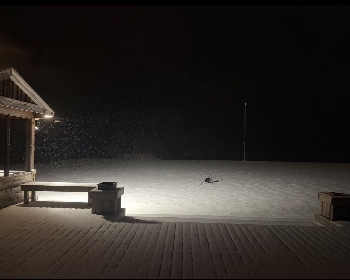
Once again SE WI actually cashing in. Moving here has been a blessing. Nothing major but not anything to scoff at either. Don’t mind my fallen over bird feeder and flag pole with no flag lol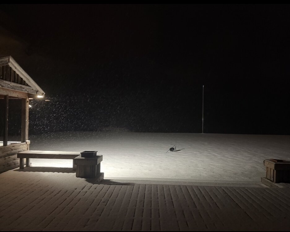
-
January 25/26 Jimbo Back Surgery Storm
LakeNormanStormin replied to Jimbo!'s topic in Southeastern States
Stay up for the GFS for hopium. And the EURO for reality. Bust city. All those clown maps were powder teases. -

E PA/NJ/DE Winter 2025-26 Obs/Discussion
KamuSnow replied to LVblizzard's topic in Philadelphia Region
Makes you want to open the windows, right? 7°F here, it's "brisk" out! -
Winter Storm Watches posted for west and middle… 727 FXUS64 KOHX 210450 AFDOHX Area Forecast Discussion National Weather Service Nashville TN 1050 PM CST Tue Jan 20 2026 ...New SHORT TERM, LONG TERM... .KEY MESSAGES... Updated at 1050 PM CST Tue Jan 20 2026 - High confidence a major winter storm will bring travel impacts this weekend. Ice may cause some power outages, mainly south of I-40. Stay tuned for the latest. - Cold temperatures are expected to remain through early next week which will prolong impacts. - Scattered showers expected tomorrow/tomorrow night with precipitation remaining as rain. .SHORT TERM... (Tonight through Thursday Night) Issued at 1050 PM CST Tue Jan 20 2026 Wednesday will begin with thickening clouds and chilly temperatures, although not nearly as chilly as we experienced Tuesday morning. Temps will warm pretty quickly as southwest wind kick in with some gusts over 25 mph. A weak system will move in with a good chance for light rain showers Wednesday afternoon and evening. This system will bring all-liquid with no wintry precip concerns. Behind Wednesday's system, high pressure will move in for Thursday with a pretty nice day. Skies will be mainly sunny with near normal temperatures. This will be a good day to complete your preparations for this weekend's wintry conditions. Things will change Friday as an Arctic cold front drops into the area, setting the stage for our well-advertised winter storm. && .LONG TERM... (Friday through next Wednesday) Issued at 1050 PM CST Tue Jan 20 2026 Here is a review of the scenario: an upper level trough will be situated off the southern coast of California on Friday. Ahead of the trough, southwesterly flow will send anomalously high moisture through the southern plains and into the southeast. This will override the cold air that settles into our area on Friday. In addition, some of that energy is expected to eject out of the Baja region eastward on Saturday. The amount of energy coming out of the southwest and amount of phasing between the northern and southern streams will impact the surface system and amount of warmadvection up into Middle Tennessee. The strength of the cold air mass coming from the north will also affect the moisture and temperature profiles. So, a lot going on here and still a lot of very possible outcomes. The latest NBM data looks generally similar to yesterday's in terms of 3/6/9 inch snow probabilities and 0.25" ice potential. This means a high-end, mainly snow event along and north of I-40. For areas south of I-40, still a significant snow accumulation potential but more of a wintry mix with potential for sleet and freezing rain. The NBM trends will need to be watched as we now have a couple of models showing a stronger warm nose building up from the south. The 18Z ECMWF and 00Z NAM are showing the 850 freezing line pushing up near I-40 on Saturday. We still think an all or mostly snow event is unfolding for areas along and north of I-40. but south of I-40 we may need to message increasing concerns for ice. If it warms enough for appreciable freezing rain, then glaze on trees and power lines will increase the risk for power outages. If the warmth is just enough for sleet, that will not impact trees and power as much, but it will make a travel mess while substantially limiting snow totals. All of this said, based on probabilities for significant winter wx amounts and impacts, we will likely hoist a Winter Storm Watch later tonight or Wednesday morning after collaboration with WPC and our neighboring offices. Our key messages are: high confidence in winter weather with potentially major travel impacts this weekend. Go ahead and make preparations and plan to stay home unless you must travel. We are growing more concerned about ice with possible power outages for areas south of I-40. South of I-40 is where the biggest questions exist. Precip type will determine how much freezing rain, sleet, and/or snow falls. Whatever falls is likely to stick around and impact travel for several days with cold air locked in place. Temperatures for some areas will stay below freezing through midweek.
- Today
-

Richmond Metro/Hampton Roads Area Discussion
eaglesin2011 replied to RIC Airport's topic in Mid Atlantic
Seriously dude… If you’re going to keep posting something like this, goto the banter thread. Ice storm or not… This is still going to be a major storm and will affect millions of people.. Stop posting nonsense! -
January 25/26 Jimbo Back Surgery Storm
LakeNormanStormin replied to Jimbo!'s topic in Southeastern States
EURO won't lie. It just screams the inevitable -

Possible Record Breaking Cold + Snow Sunday 1/25 - Tuesday 1/27
snowman19 replied to TriPol's topic in New York City Metro
I would wait until Thursday when the players are actually on the field and all the models get the new data. I’m sure weather balloon launches will increase and recon flights will definitely be in the air on Thursday. I call BS on the EURO. Suppression is a very real threat -
January 25/26 Jimbo Back Surgery Storm
LakeNormanStormin replied to Jimbo!'s topic in Southeastern States
There is a kink somewhere. Cold is all kinds of backed up in Canada. Something is modeled wrong. Either HP is weaker as advertised. Or the Baja low does something unexpected in its phasing. Something isn't right. -

Central PA Winter 25/26 Discussion and Obs
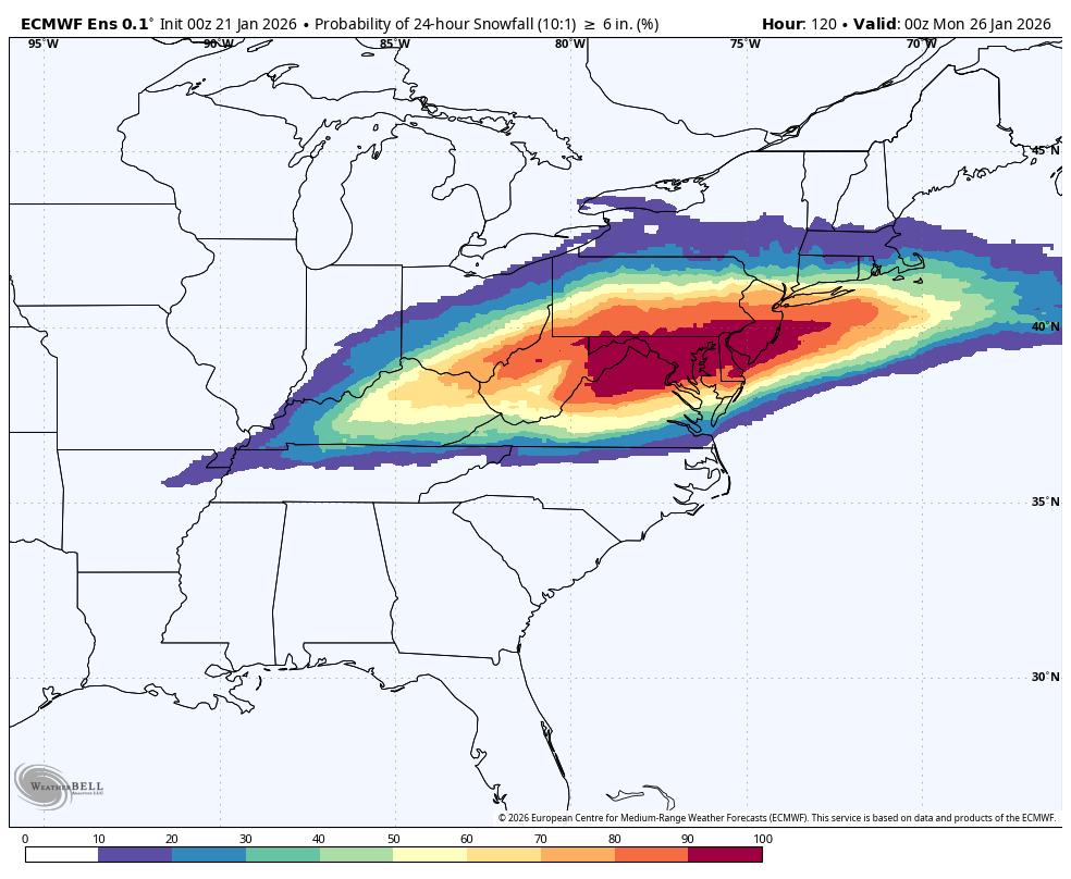
MAG5035 replied to MAG5035's topic in Upstate New York/Pennsylvania
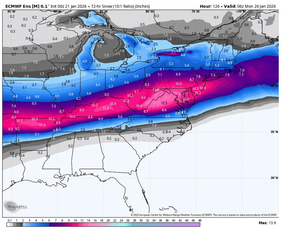
0z Euro ensembles continue to look better for heavier snows in PA, probs for 6”+ in a 24 hour period (at just the 10:1) are 80% or higher for about the southern third of the state now. 0z Euro ensemble snowfall mean
-
Maybe It will make to 60 here Sunday. Huge north jump on EURO.
-
I haven't been around for many of them but usually there's always some issue like no real high pressure, no real cold air source to our north, relying on dynamics etc.. That's where the NW trend kills chances. Correct me if I'm wrong but you usually don't see this setup where there is tons of arctic air to our north, hp systems in place and this sort of retreat. Just looks wonky to me...but I'm out of practice.