All Activity
- Past hour
-
Just curious, but do you send pics to NWS MQT?
-
I didn't expect a real winter, not with that Pacific jet out there...
-
@eyewall I thought the same thing when I walked out yesterday morning and posted here. It didn’t feel like a volatile airmass especially with the midday timing. Unless it’s a derecho or there isn’t any morning convection at all midday almost never works for severe. I never saw the sun yesterday btw.
-

-
30.7° at 10 am is just flat out impressive for this time of year
-
It would be, if it weren't so windy...
-
jelly
-
 .32" from the first round and .64" from last night. Not much wind fortunately. Snow fell for about an hour last night with no accumulation. Mountains are white this morning though. Much needed rain, at least.
 -
This is EXCELLENT. The last thing he says is why this shouldn’t have been a 4 though: “There were a lot of questions, a lot of failure modes going into it”. If that was the case, the upgrade was not warranted because a level 4 risk states “high confidence” as a prerequisite to issue. If this had been kept at a level 3 overnight due to those questions the public would not have reacted the way they did and the perceived bust would be much less significant. Just my 0.02 but rarely so we see a day 2 level 4 and it seemed so preemptive we didn’t even start a thread here
-
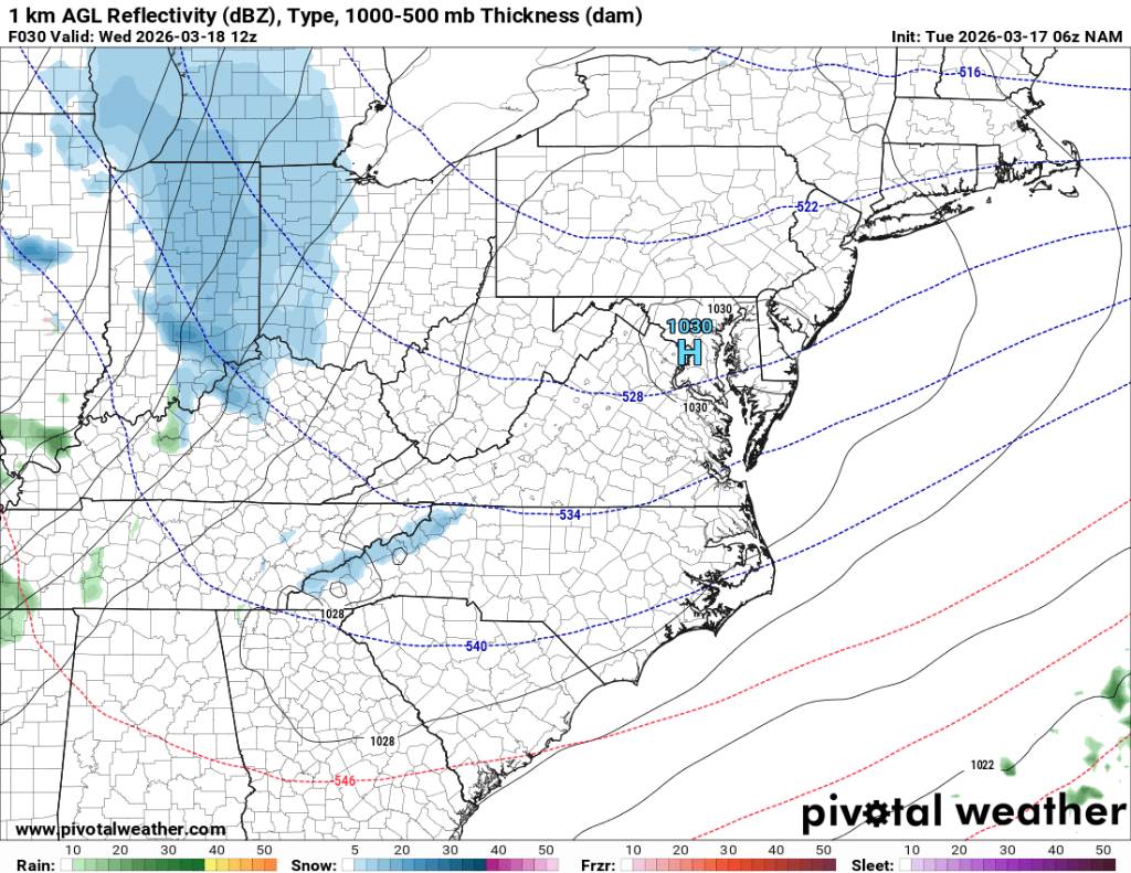
A lot of LES/enhancement up there around MQT but a nice storm nonetheless.
-
35 right now Beautiful morning
-
Yeah I knew it when the air didn't have the feel of an outbreak day like it did on 4/16/2011. On top of that as you stated the winds were calm and that is definitely not how it goes around here on most high end days.
-
Epic storm
-
The last week's worth of the solar transition has been hidden from our Earth because of this unrelenting agenda by Earth to jam New England cold enthusiast heads in the sand. heh ... I'mmm fairly certain that come April 10, the March global temperature anomalies will again, for the 6th consecutive month, have an isolated blue node situated conveniently over denialism town squares. It's a warm sun ...for all intents and purposes, and equinoxian sun. Btw, the equinox is on the 20th this year, good for another 1.5 solar diameters-worth of sky ascent. Sun rise to sun set will soon be longer than 12 hours. I carry no secrets in the matter ... at this time of year I am all in a warm season enthusiast, so this all suits me just fine. Having offended (hopefully) with all that, I am still objective when looking and charts and data. I don't see interesting warmth, or interesting cold really through April 1. There's arguments for either, pretty much offsetting. Which means that either could lean on verification and it's not outlandish. "Bowling season" is a hypothetical three-week sorta window when packets of stronger atmospheric mechanics are at risk of being pinched off/abandoned by the increased background tendency for jets to retreat N. Give that antic a month's room to breath. We'll have to see how that goes, but in an even money spring, that averages to less snow as a base line probability, which defaults to bowling ball cut off cold pocket lows as the wild card. It seem this is best fit for all indicators and interpreting operational model tenors, for those cannot find the courage to go on with life in the face of the type of weather that actually 97% of humanity prefers. haha.
-

E PA/NJ/DE Spring 2026 Obs/Discussion
The Iceman replied to PhiEaglesfan712's topic in Philadelphia Region
I just want to add to the conversation over yesterday’s event and the very poor job of messaging for this event. Tornado watches were cancelled by 6 pm so he had thought he was in the clear and ended up getting caught out in that awful squall line because he and many others out last night other assumed the worst was over. I have no idea why we didn’t transfer into a severe thunderstorm watch. SPC did a terrible job all around yesterday imo they overplayed the tornado threat and downplayed the wind threat after the tornado threat failed. -
lesson 2 be learned here for some
-
Wow. That was probably the loudest explosion I've heard. The band is just north of here... sitting between 87 and 322.
-
 0.5" snow here in Round Hill and Berryville Drove through Bluemont last night, maybe a couple of inches where Rt 7 and 601 meet
 -
Nothing in my immediate area but looks like alot of damage around town. Trees and power lines
-
E PA/NJ/DE Spring 2026 Obs/Discussion
The Iceman replied to PhiEaglesfan712's topic in Philadelphia Region
RIP he went back to the eastern days.. Always such a respectful poster. -
One red flag with this system is pretty academic but with high end events in this area they almost always have significant outbreaks west of here before arriving. This event underperformed massively the day before, with just 6 weak tornado reports. Not much science to that as the atmosphere is fluid and a system can certainly change overnight but usually major severe outbreaks in the south start out in midwest and move into our area
-
Won't be much but as cold as it is a little light snow could cause some road problems tomorrow morning. Sent from my SM-G998U using Tapatalk

-
Just heard at the office that it could have been a meteor. BTW, you should be getting hammered now under that stationary snow band.
-
Another thing is don't look now but looks like the AO and NAO are looking to go negative towards the first of April. Also the PNA looks to ease up so don't get too excited for long term warmth.
-
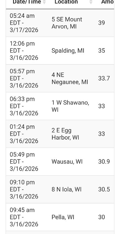
Somewhere around 300". I'm usually pretty close to Herman's totals and they stand at 341" as of today but there were a few times this winter they were hit a bit harder than me. Measuring snow here is damn near a fulltime job and I just don't care as much as I use to. However, from Friday through last night I've received an estimated 55" while MQT officially stands at 48.1" during the same time, with a season total of 262.7". Today starts the cleanup. There's 4-5' drifts of wind-packed snow across the entire driveway this morning and while I do have a Kubota tractor, this is still going to take some time. Will try to post a few more pics today.