All Activity
- Past hour
-

December 2025 Short/Medium Range Forecast Thread
Carvers Gap replied to John1122's topic in Tennessee Valley
What I see from the 12z GEPS and EPS is very cold air in Canada that keeps pinwheeling into the US old school style. And that setup is a very stable pattern unlike other cold patterns we have seen. JB noted that wave lengths tend to shorten up during phase 8 and wx models will often struggle with details and strength of cold shots. If we kind of assumed this pattern began just after Thanksgiving, it makes sense for it to last to Christmas or just after, then Jan is likely warm, followed by another cold shot. This set-up reminds me a lot of 95-96 in terms of the overall sequence(maybe not the snow). Last winter did as we'll. -
2002, 2005, 2007 and 2009.
-
Geographically Bellayre is souther NY state. It's weird how the population of New York views everything 30 miles north of where they live as upstate. Binghamton is the southern tier of New York and that area is referred to as such on thruway maps, yet 90% of the residents of NY view it as way the hell upstate.
-
More Tik Tok rescues?
-

Richmond Metro/Hampton Roads Area Discussion
chris624wx replied to RIC Airport's topic in Mid Atlantic
I guess I'll just be happy to see flakes flying. Doesn't look like anything to get real excited about down this way. Hope everyone away from the coast cashes in! -
December 2025 Short/Medium Range Forecast Thread
Carvers Gap replied to John1122's topic in Tennessee Valley
The Euro, after stumbling and bumbling for 4-5 days(losing the pattern), has a reasonable transition of the MJO. I think it just keeps rotating around. The GFS/AmericanModeling has tried to loop it around and been wrong with that on multiple occasions. Does it stall? It may. To me, this looks like it will transit cold phases, go COD 3-5, exit into a strong 6, and come right back around. The GEPS and EPS looks decent in the long range. The GEFS keeps pushing back the flip. I do think we see a ridge(maybe???). -

December 2025 regional war/obs/disco thread
powderfreak replied to Torch Tiger's topic in New England
All joking aside, these are some truly rugged conditions outside at the mountain. Full-on whiteouts and howling wind. Even the ASOS in the valley is registering the rare M1/4 under quarter mile vis… METAR KMVL 041825Z AUTO 34015G21KT M1/4SM +SN VV009 M08/M11 -
-

Winter 2025-26 Medium/Long Range Discussion
hawkeye_wx replied to michsnowfreak's topic in Lakes/Ohio Valley
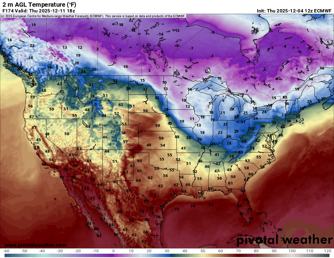
It's a very active pattern over the next couple weeks. There will be an alternating series of brief mild and cold surges. The Euro is showing quite a temp contrast a week from now between the plains and lakes.
-
Oh look, another attempt at a warm up (after next weekend) that looks muted all of a sudden... Op runs are super active, if northern stream dominated (as expected).
-
Moving to by far the warmest part of NY state didn't help. I realize it would mean commuting but living 40 miles north of midtown makes a world of difference.
-
Not sure what exactly is LWX's criteria is for a WWA but I'm a little surprised they have pulled the trigger for the DC metro (or at least south of the Potomac) given (1) upside potential of an inch+, (2) timing (morning commute), (3) cold ground/road temps at onset, and (4) first event of the season.
-
I like how the thread title Says " snowstorm" lol seems a bit over doing it there lol
-
Should be posting 20:1 maps with these conditions! Where's @paulythegun?
-
The last snowplow blade:
-
5 or 6 times since 2002 I beleive
-
Congratulations.
-
Anyone remember how many times it has snowed on the 5th in recent memory?
-
Well said. Didn't realize this board was around 100 years ago. And we still have some original members
-
.thumb.png.4150b06c63a21f61052e47a612bf1818.png)
December 2025 regional war/obs/disco thread
HIPPYVALLEY replied to Torch Tiger's topic in New England
They generally get ripped apart over the Berkshires. -SN and breezy here. -
Watch Baltimore get 2". You can eat @Terpeast shoe. Oh and don't forget to wipe.
-
Not even close for us
-
Mesonet data shows that four inch soil temperatures west of the bay have fallen to the upper 30s to near 40 degrees. Ground is primed for snow.
-
I’d like to know what they’re seeing. That’s a substantial increase for an area that by all accounts, won’t dip below 35.
-

Winter 2025-26 Short Range Discussion
A-L-E-K replied to SchaumburgStormer's topic in Lakes/Ohio Valley
it's your year friend