All Activity
- Past hour
-

Possible coastal storm centered on Feb 1 2026.
CoastalWx replied to Typhoon Tip's topic in New England
I’m hoping this has a massive slug shoved well into SNE vs a narrow occluded band. -

Possible coastal storm centered on Feb 1 2026.
ORH_wxman replied to Typhoon Tip's topic in New England
CFS? Lol. Surprised Ant didn’t pull out the Korean. -

The Jan 31 Potential: Stormtracker Failure or 'Tracker Trouncing
The Dude replied to stormtracker's topic in Mid Atlantic
Interesting snippet from LWX's AFD: Nothing has changed in terms of the pattern for a storm along the Eastern Seaboard this wknd. A 50/50 low & -NAO, Idaho Ridge, blocking over the Hudson Bay, and trough moving into the east Pac. Couldn`t ask for a better synoptic setup, but the formation of a storm remains in the details of this highly sensitive pattern. Latest guidance does reveal northern stream energy is a little stronger and further west/slower. Therefore, eventual ULL is slower to push eastward and slightly further west. This has resulted in a slight shift west in recent storm tracks. Will have to continue to monitor if this is a trend or noise. While the ceiling is certainly high for this storm, there is equally if not higher odds it just skirts out to sea. Future runs will have to be seen if this is a trend or noise. How the TPV evolves will be one of the biggest factors on if this storm comes to fruition or not and impacts land. TPVs are notoriously not modeled well given the source location with limited UA data. Therefore, expect fluctuations over the next day or so until the pattern is better sampled as associated energy is onshore across the western US. -
0Z CFS was a big hit....12Z CFS runs later....not sure how good this model even is.....
-
I think 1st half is cold/dry though def not snow free but second half gets a lot more active with that blocking pattern + RNA
-

Possible coastal storm centered on Feb 1 2026.
dendrite replied to Typhoon Tip's topic in New England
This is low even for you. Go find someone with a headlight out or something. -
Morning ob after driving to work.....local DOTs have really forgotten how to appropriately clear roads. In many spots, you almost wonder WTF they were actually doing.
-
 Through 7:00 am Saturday
 -
Want a band swath instead of banding to come in, if it comes in. we get the right flow as it moves (for mby yard is it SSW -> NNE then pivots to EEN - > SWW. Boom
-

The “I bring the mojo” Jan 30-Feb 1 potential winter storm
eyewall replied to lilj4425's topic in Southeastern States
yes but again expect adjustments and honestly I am hedging a little low for some spots I am sure. -
(002).thumb.png.6e3d9d46bca5fe41aab7a74871dd8af8.png)
Central PA Winter 25/26 Discussion and Obs
ChescoWx replied to MAG5035's topic in Upstate New York/Pennsylvania
I could only find one Chester County station that fell to below zero this morning and that was our usual cold spot up in Warwick Township with a low of 2.6 below zero. Almost all spot saw lows in the single digits above zero. If anything, we get progressively colder the rest of this week with highs through Saturday several degrees lower than yesterday. Highs will be in the mid to upper teens with lows near zero to below. The potential weekend storm still looks like it will miss our area to the east toward the NJ shore but will need to be watched for any potential changes.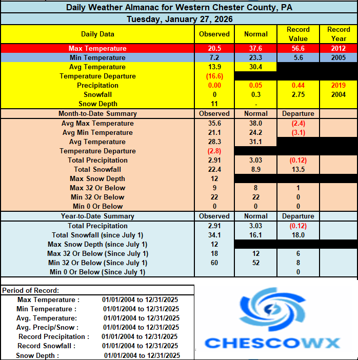
-

Possible coastal storm centered on Feb 1 2026.
40/70 Benchmark replied to Typhoon Tip's topic in New England
It's also important for us in the east as far as high-end potential is concerned.....I would cap things around a foot if it were to close off so far south. -
E PA/NJ/DE Winter 2025-26 Obs/Discussion
ChescoWx replied to LVblizzard's topic in Philadelphia Region
I could only find one Chester County station that fell to below zero this morning and that was our usual cold spot up in Warwick Township with a low of 2.6 below zero. Almost all spot saw lows in the single digits above zero. If anything, we get progressively colder the rest of this week with highs through Saturday several degrees lower than yesterday. Highs will be in the mid to upper teens with lows near zero to below. The potential weekend storm still looks like it will miss our area to the east toward the NJ shore but will need to be watched for any potential changes.
-

Central PA Winter 25/26 Discussion and Obs
Mount Joy Snowman replied to MAG5035's topic in Upstate New York/Pennsylvania
The river by MDT is completely indistinguishable from the surrounding terrain. Just pure frozen tundra. -
EPS 6z today vs 0z today and 12z yesterday... Baby steps toward a more impactful storm closer to the mid-Atlantic coast. Notice the western US ridge shifts slightly further west and stronger in more updated EPS runs, while the "kicker" shortwave from Hudson Bay to Manitoba/Ontario and MN shifts weaker. Also the TPV drops down further west and the departing upper trough over SE Canada is a little weaker, allowing better height rises over the W. Atlantic and New England ahead of the TPV.
.gif.a04df27f93a15a79ca628ae09ad2bad2.gif)
.gif.affcaf990ac1d64806ea35037ae4b73a.gif)
.gif.b46e6e96633988d43016186cba2842ff.gif)
-

Central PA Winter 25/26 Discussion and Obs
pasnownut replied to MAG5035's topic in Upstate New York/Pennsylvania
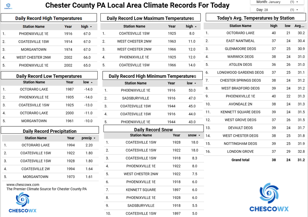
Yeah I only saw 5. Was expectin neg digis. -
Cfs huge hit
-

The “I bring the mojo” Jan 30-Feb 1 potential winter storm
AirNelson39 replied to lilj4425's topic in Southeastern States
That’s a pretty significant shift from what it’s been showing the last 2 days. Good sign -
Cfs huge hit
-
 This is what I liked about the EPS this morning, the 90 hour 6-he qpf map has beefier precip further west into southern va and western nc.
 -

The “I bring the mojo” Jan 30-Feb 1 potential winter storm
BornAgain13 replied to lilj4425's topic in Southeastern States
Latest SREF through 7 pm Saturday. Lighting it up!.thumb.png.6ae14dee8a5201a23ad66c0472716e7f.png)
-
Interesting stat from Brian B. Climatologist49 @climatologist49.bsky.social Follow Newark Int Airport reported Heavy Snow and a temperature of 11F. This is the lowest temperature on record for them (1930-present) where they reported Heavy Snow. Previous record was 12F in 1932 and again in 2014. 12:23 PM · Jan 25, 2026 Everybody can
-
I remember that storm like it was yesterday with the infamous "convective feedback" Heard it was one of the top analogs for the coming storm too.
-

Possible coastal storm centered on Feb 1 2026.
Ginx snewx replied to Typhoon Tip's topic in New England
Go to CIPs analog page -

The “I bring the mojo” Jan 30-Feb 1 potential winter storm
BooneWX replied to lilj4425's topic in Southeastern States
I can’t wait to see the NAM in a bit


.png.631e3738ce92b58834df2a9699f2b2ab.png)

