All Activity
- Past hour
-
Well, given the SPC issues the watch, that means that specific parameters are expected to be in place for severe storms to develop that could produce a tornado. Reading the NWS AFDs they almost always mention SPC and repeat what they have discussed about the risk(s). So once a storm has formed in a watch area and shows signs that it could produce a tornado, should they just ignore it because we are in the east and some imaginary quota has been reached? lol this is so dumb.
-
Some spotty isolated showers/storms are building.
-
 Start just before 5pm EDT: Rather than clog the other threads I wanted to post my full storm chase recap in a separate thread. It all began on the afternoon of July 28th near Sandy Ridge, NC (northeastern Stokes County near the VA line. A supercell organized south of Floyd, VA and began moving southeastward in northwesterly flow. This means the business end of the storm was on the northwest side of it as opposed to the usual southwest. None the less it had a classic structure when we first intercepted it. If it was more LP and there were less low-level clouds a barber pole with bell shaped base would have likely been fully visible. You can infer it was there from the shot below along with a well developed wall cloud: We were able to stay with this storm for over three hours with good southeasterly routes available. It was at this first location in Sandy Ridge where I was nearly hit by an intense CG strike (definitely within yards). The next shot shows the wall cloud with a strike to the right of it (video cap): The next stop occurred some 20 minutes later in Ayersville, NC but we could not stay long to keep up. At this stage the storm entered a re-organizing phase. After that was Madison, NC where we got a good look at the meso: After that the next stop was around 1 hour into the adventure southwest of Reidsville. I got video of the meso but have yet to post it. In terms of stills I got the wall cloud here: This is when we made a wrong turn and ended up taking the brunt of the RFD which rained down tons of tree debris. Whole trees came down as well. We got back on the storm in Alamance County near Sedalia and Graham. This is where the storm structure really ramped up again with a clear slot due to the RFD wrapping in and meeting up with a strong inflow tail. The rising motion into the storm was violent and very Plains like and there were renewed lightning barrages. At this point the storm was tornado warned. Here are a series of images I got from over a Waffle House parking lot just south of I-40 off 87 in what is technically Graham. The next stop was between Graham and Saxapahaw at the intersection of Swepsonville-Saxapahaw Rd and Crawford Rd. This is where I caught a funnel cloud for the first time on this storm. This was confirmed by video evidence from another chaser as I was focused on stills. It also matches up to where the meso is and the overall storm structure. At this point we are 2.5 hours in just after 7:30pm. Images from that stop here: After this I was thinking of breaking off and headed home until the rotation strengthened again between Saxapahaw and Carrboro (Oaks to White Cross) as the 3 hour point approached on this storm (an rare feat in NC!). The storm did not disappoint and made an attempt at producing once more. I cannot draw any conclusion if it touched the ground or if it was condensation of the trees rising up but none the less for now I will call it a funnel cloud seen here along with the overall storm structure: I tried to keep up with it a bit more into Carrboro and did so but another violent lightning barrage occurred there and the storm was being overtaken by upscale growth which merged everything into a big rain-filled cluster. It was also getting dark so I headed back to Raleigh. All in all this was one of the most incredible chase experiences I have had and I will not forget it. Bonus shots below:
 -
I got hit with like 6 of them yesterday. I think I wound up with .28"
-
 81.4°, sunny, and very safe to close the month
 -
.thumb.gif.f92b16c631a1d15d405ed77b33f0710d.gif)
Dewgust 2026: Summer's Last Stand
Torch Tiger replied to Prismshine Productions's topic in New England
Looks active for the first two weeks. Maybe some severe -
Ok im going to nerd out and vent here. For those who dont know, after they got creative control from Stan Lee Marvel decided Spider Man was easier to write for single and also said, and Im not kidding, that fans relate easier to a single lonely spider man. Apparently they think the fans are all incels. So they had him make a deal with the devil to erase his marriage to Mary Jane to save his 70 year old aunt. And no they arent unhappy in their marriage. They are both insanely in love which makes the story even more insulting. And frankly character destroying. How can you root for someone who would do something that horrific? The writing was lazy. The premise was ridiculous. The justification was insulting. It’s the one time Stan Lee violated his agreement not to criticize Marvels creative decisions. He also undid it in the news comic strip he kept editorial control of before his death and severed the continuity between his strip and the marvel comic because he was so upset by what they did to his character. The main writer at the time MJS who also wrote Babylon 5 wanted his name taken off that issue he was also so bothered by it. My reaction was simple. I checked out. I have not read or watched a single Marvel anything since. Not a single spider man. Not a single avengers. Nothing. I won’t give my money to an organization that insults me to that level. What amazes me is I’m not alone in my assessment of “One more day”. It’s widely considered the most hated comic story ever. There are thousands of online forums dedicated to how much people hated it and want them to undo it and put Peter and MJ back together. But then I see those same people posting about going to see Avengers or the new Spider Man movie. I am just as annoyed with them as I am Marvel. If they stopped giving them $ like I have they would have undid their mistake a long time ago. When I started my own personal boycott 19 years ago now I thought it would take 5 years tops before they undid this nonsense. It was so hated. But everyone got angry then continued to read and watch anything marvel put out and 19 years later I’m still waiting. I won’t ever read or watch until they undo OMD and get them back together and I don’t mean the casual dating they sometimes allow I mean restore the stable marriage they had and stop thinking spider man had to be a miserable single screw up to be a compelling character. His most popular run was the decades he was married. Anyways why are people supporting a franchise that would insult them this way? I don’t mean the casual fans who have no idea what I’m talking about. I mean the ones who fill up Reddit with how mad they are then go to the next movie.
-

2026-2027 Super El Nino
bluewave replied to Stormchaserchuck1's topic in Weather Forecasting and Discussion
The summer of 1991 only had a weak El Niño in progress as opposed the strongest on record this summer. July did have some similarity to the composite. But sometimes weaker El Niño summers in the past had more heat than the stronger developing ones. This was the case in 2002 also. So it has been common in the past for weaker El Niños to have less influence in the midlatitudes than during developing super El Niños like 2023, 2015, 1997, 1982, and 1972 which had the more typical cooler summers. The big story this summer is how out of phase the mid-latitudes and tropics are for the magnitude of this event.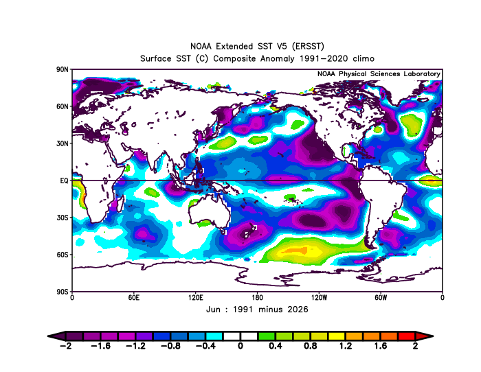
-
Ive never been able to figure out why some people are bothered by people who post long range forecasts. All of those forecasts should be taken with an iceberg type grain of salt. I cant recall the last time Ive read or watched one of those types of forecasts Some of the people are laughing all the way to the bank because of people clicking on or watching their long range forecasts. At the end of the day the vast majority of them are going to do what generates the most page/video hits. For the most part they arent concerned about their forecast being right. They are focused on making money by using headlines to drive people to their sites That is how the game is played. At the end of the day there are more important things to be concerned with.
-
 Very hard to buy the GFS when ensembles across the board go the opposite direction.
 -
 Viagra generic over the counter or generic sildenafil sildenafil online http://u.42.pl/index.php?descr=cinquantenuancesdegreystreamingvf19641&url=https://medmennews.com Generic Viagra for sale or https://lifnest.site/user/nbirbatvgcnbirbatvgc/?um_action=edit Buy generic 100mg Viagra online [url=https://clients1.google.ne/url?q=https://medmennews.com]over the counter sildenafil[/url] Viagra Tablet price and [url=https://www.emlynmodels.co.uk/user/cfhpidrauz/]Generic Viagra for sale[/url] buy Viagra online
 -
 Supertyphoon Dolphin, almost the same as last night, 130kt as per JTWC
 -
….. and colon? ….. As always …….
-
Supposed to go to Assateague Sun-Wed. Looking iffy at best after Sunday.
-

2026-2027 Super El Nino
GaWx replied to Stormchaserchuck1's topic in Weather Forecasting and Discussion
Hot off the press from another source posting the 8/1/26 Cansips run of Nino SST anomalies. It is continuing the CanSIPS run trend of moving the strongest warm SST anomalies further and further east at the ~Nov peak. That’s not surprising because I’ve been suspecting a Modoki bias for it based on the past few years of analyzing it as I’ve posted a number of times here before. The April-June 1st runs had the warmest anomalies near the Dateline/straight Modoki (W based) in the peak month of Nov. Then the July 1st had warmest anomalies in Nov further E near 160W, more of a cross between central based and Modoki. The new Cansips run’s Nov peak shows the warmest anomalies centered near 130W, which would be centered in E Nino 3.4/Nino 3 making it pretty E based. Though this run is not as E based as 1997-8, stay tuned to future runs because the E trend of the strongest anomalies on Cansips from run to run may very well not be done due to this suspected Modoki bias. I can’t post it because the file size is much too large for me to have room in my account. But when it comes out on TT and WxBell, those will be smaller files and thus postable. -
 I don't disagree there could be something weak, but GFS looks wild.
 -
Keep Friday's sunny. We tan.
-
thank you!
- Today
-
 happy to be skipped here
 -
A real summer day today for a change! No rain and warm but not hot
-
Low of 67. Monthly stats: Highest temp: 98 Lowest temp: 66 Rainfall: 7.76"
-
It’s unreal how I’m getting skipped over. Unreal.
-
 Jeezuz, storms just keep popping up north of Brattleboro and sliding right down the valley. Pouring again.
 -

2026-2027 Super El Nino
Stormchaserchuck1 replied to Stormchaserchuck1's topic in Weather Forecasting and Discussion
Yeah, the real connection is with global temperatures. A huge trough over the North Pacific is necessarily Winter disaster for the east coast.