All Activity
- Past hour
-
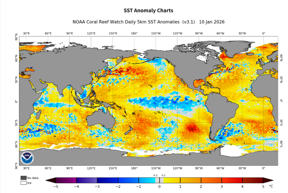
The warm SST'S into the GOM are a breeding ground for strong storms right now,really would hate to see cold get penetrated into the region,of course for people into that region time to time you see winter modeled into that region even tho its fantasy range
-

E PA/NJ/DE Winter 2025-26 Obs/Discussion
The Iceman replied to LVblizzard's topic in Philadelphia Region
After 30 + years of living here, I enjoy pretty much anything that makes it white outside. Looking pretty good for that still. -
Plz King Euro. I don’t ask for much!
-
@psuhoffman For us Northern tier folks, most of us are somewhere between 2 and 4 inches on the season. Question for you- Which is a higher probability. Finishing with less than 10" or more than 20"?
-
It's still there. It's just now more of a severe thunderstorm threat lol.
-
1-3/2-4 is dinkleshit and I’d rather it rained. More and more I’m go big or go home. I absolutely loved walking 6 miles late yesterday without a worry of slippery conditions. These 2 systems seem to be gateways into the next pattern. So I’d lean the 18th for a chance of something big but better chances 1/20-2/5.
-

2025-2026 Fall/Winter Mountain Thread
nchighcountrywx replied to Buckethead's topic in Southeastern States
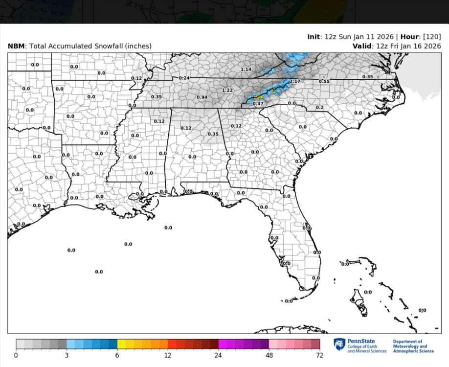
1052 AM EST Sun Jan 11 2026...SNOW AND GUSTY WINDS ACROSS THE NORTH CAROLINA MOUNTAINSTHROUGH THIS AFTERNOON...Reports of light to moderate snow with gusty winds are coming outof the North Carolina mountains. Snow will continue to fallthrough the early afternoon hours with wind gusts of 20-30 mph,and locally stronger gusts at higher elevations. A light dustingof snow is possible, with up to an inch at the highest peaks. -
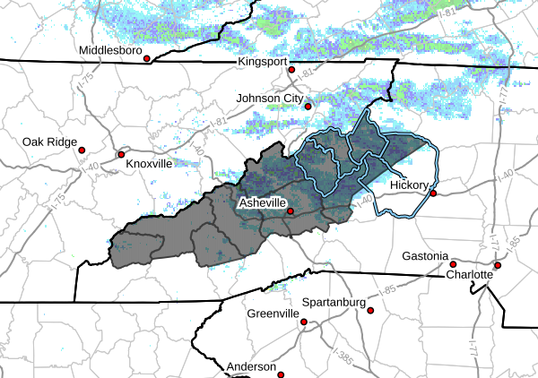
When I lived up there, days like today were my favorite. Steady flow is fun but these are basically thunderstorms. Just peaked at the blowing rock cam and the height on those cloud tops would make you think it’s June if you didn’t know better.
-
Yeah snowing nicely here. Big flakes, very windy and very cold with windchills in the teens.
-
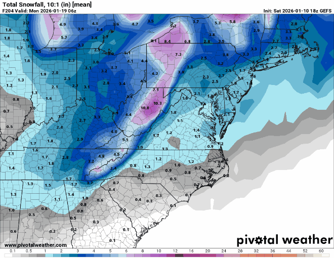
Last 4 runs of Gefs snowfall for period ending 186hrs on 12z run. Definite, slow improvement.
-

January 2026 regional war/obs/disco thread
40/70 Benchmark replied to Baroclinic Zone's topic in New England
Yea, this is the time of year I gave up last year and I'm getting close...only difference is I have more hope for late year than I did last season. -
GEFS looks pretty threatening for SE areas and cape.
-

Central PA Winter 25/26 Discussion and Obs
WmsptWx replied to MAG5035's topic in Upstate New York/Pennsylvania
And it's over. -
12z GFS Ens. definitely upticked on both Thursday's storm and Sunday's.
-

January 2026 Medium/Long Range Discussion
Scarlet Pimpernel replied to snowfan's topic in Mid Atlantic
-
Will be interesting to see the strength of number one and how that affects number two.
-
Agree. What are your thoughts on the 17th system?
-

Central PA Winter 25/26 Discussion and Obs
Voyager replied to MAG5035's topic in Upstate New York/Pennsylvania
Well, I guess we can't go more than 24 hours without salt covered roads...ugh. -
this has cape special written all over it. It’s a James storm for sure.
-
Here is the feature I am talking about. See this long arc of moisture feeding Into the Tenn and Ohio Valleys from the eastern Pacific. This is a southerly displaced Pineapple Express(loosely defined I freely admit). The Euro AIFS has had this from time to time. I just think this is not likely. HOWEVER, if the feed only tapped the Gulf...this is plausible and can't be ruled out. Scottie asked if the setup has precedent. I am actually going to change my answer. It does have precedent now that I can see this view, BUT really no other model(exception AIFS) has this. If there is any model that could score a weird coup, its is the GFS...but it just seems like an outlier at this point which has to be discounted (with system 2) until it gets some more support. It would be remarkable or the GFS to nail this....
-

January 2026 regional war/obs/disco thread
qg_omega replied to Baroclinic Zone's topic in New England
Pattern than completely collapses -
Haha. just came to post the same.
-
I said yesterday I thought the midweek system is likely somewhere between the bombs shown on the GFS and the relatively light Euro/GEM runs. I don’t see anything yet to sway me from that….
-
It's not great to have the key shortwave missing or in an unfavorable location on the ICON and GDPS... and also the short range NAM and RDPS. Even by 72 hours it's clearly missing... that's approaching short term modeling range.
-
True,thats a uptick even since the 12z,not much but something is better than nothing..lol