All Activity
- Past hour
-

Possible coastal storm centered on Feb 1 2026.
mahk_webstah replied to Typhoon Tip's topic in New England
This isn’t our storm. but if forced we would take it. but I hope youse get it -
Yeah ok 14 that's right.
-

Possible coastal storm centered on Feb 1 2026.
Kitz Craver replied to Typhoon Tip's topic in New England
HH did lock it, but that run up in modeling had steady positive trends almost in its entirety. This one hasn’t had that at all. I get SWFE is easier to predict, but this has felt opposite. Tip started the thread and it was biblical, we’ve been slip sliding away ever since. -
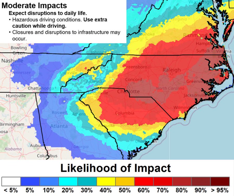
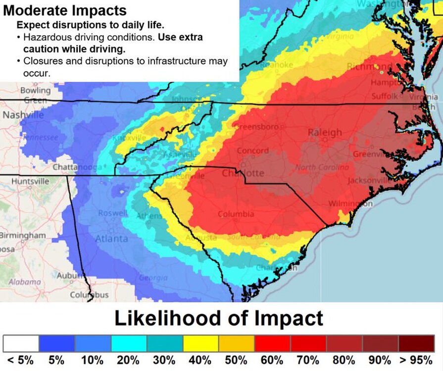
DT-WxRisk @wxrisk.bsky.social · 1h WED AM UPDATE ON FRI - SAT NC VA DELMARVA se New England SNOWSTORM youtu.be/TP5lGA9wl24 last few runs GFS MODEL still has blizzard for Nc/ va / Delmarva - Thats is BS. BUT good chance of a significant snow -maybe 10" in NE NC / Norfolk metro ..several inches RIC LYH ROA GSO DAN.
-

Possible coastal storm centered on Feb 1 2026.
Ginx snewx replied to Typhoon Tip's topic in New England
There's a CNE NNE vibe that is funny. Looks good for ESNE perhaps but just pay attention -
yeah, I've seen it when it's snowy there. Beautiful thing

-

The “I bring the mojo” Jan 30-Feb 1 potential winter storm
fig replied to lilj4425's topic in Southeastern States
when you live in the little orange area just south of Wilmington... -

1-30/2-1-26 Arctic Blast, ULL Snow Event
fountainguy97 replied to John1122's topic in Tennessee Valley
Euro joins the ULL mountain focus and a late blooming coastal solution. It and weathernext are locked in.
-

2025-2026 Fall/Winter Mountain Thread
CheoahBald1 replied to Buckethead's topic in Southeastern States
My job is based outta Jackson co but I cover all of Division 14. Basically from Murphy to Haywood co. . -

2025-2026 New England Snow Recordkeeping Thread
codfishsnowman replied to bristolri_wx's topic in New England
15 from the monster SWFE 34.4 on the season -

The Jan 31 Potential: Stormtracker Failure or 'Tracker Trouncing
SnowGolfBro replied to stormtracker's topic in Mid Atlantic
Hey that gives my backyard 1.5 inches at 10-1 and with rates could be like 10-20 -
Possible coastal storm centered on Feb 1 2026.
Ginx snewx replied to Typhoon Tip's topic in New England
Wut? How many many many times 4 days out have we had the rug pulled with a 100 mile shift ots. All it takes is tiny initialization issues. Last storm didn't lock in until the Hurricane Hunters data started getting ingested. -

The Jan 31 Potential: Stormtracker Failure or 'Tracker Trouncing
psuhoffman replied to stormtracker's topic in Mid Atlantic
@Terpeast @MN Transplant @WxUSAF Question... something I've noticed anecdotally over the last 20 years, when 3-5 days out we have models projecting a favorable H5 feature for our area...it trends north a significant majority of the time. However...when guidance has a cutoff h5 feature projected too far south of us...it does not tend to trend north as often. I can think of a logical reason, perhaps if a cutoff is far enough south its far enough removed from the NS flow and not impacted by minor variations the models typically get wrong...and which cause the north bleed in these features when they are around our latitude. Just wondering if you have also noticed this and if there is something to it, besides just random chance and us getting really unlucky lately. -

The “I bring the mojo” Jan 30-Feb 1 potential winter storm
olafminesaw replied to lilj4425's topic in Southeastern States
-
https://x.com/SegravesNBC4/status/2016568040045871476 What a joke
-

The Jan 31 Potential: Stormtracker Failure or 'Tracker Trouncing
adelphi_sky replied to stormtracker's topic in Mid Atlantic
Waiting for those glorious words from a met, "I don't believe the models have a good handle on this." -

The “I bring the mojo” Jan 30-Feb 1 potential winter storm
ncforecaster89 replied to lilj4425's topic in Southeastern States
https://x.com/tbrite89/status/2016579926112010698 A football analogy to characterize how I view our current position on the field. -

The “I bring the mojo” Jan 30-Feb 1 potential winter storm
Regan replied to lilj4425's topic in Southeastern States
I’d say lately, 3in fo rdu would be a win, but I’m rooting for much more. Especially if it’s not messy snow. -

Possible coastal storm centered on Feb 1 2026.
78Blizzard replied to Typhoon Tip's topic in New England
There were a dozen good hits in there for E MA. -
Looked at euro aifs whole run. It has been good so… Feb 5 thought looks like front with low to north Feb 11 moist storm perhaps swfe with track thru cne maybe clipper or 2 in between.
-
January 25-26th, 2026 Final Storm Totals
codfishsnowman replied to The 4 Seasons's topic in New England
15 here in the very southeast part of Springfield MA. I have it on good authority that just one or two miles away there is quite a bit more in Longmeadow but this is all I can report in good conscience. Very dense and kind of heavy to move despite readings in the single digits while it was falling. We had a good 3 inches already otg so otg totals combined briefly hit 18 inches or so. Amazing event just poor snow growth the duration....even what little fell Monday only had decent growth for a few minutes morning and evening -

The Jan 31 Potential: Stormtracker Failure or 'Tracker Trouncing
Buddy1987 replied to stormtracker's topic in Mid Atlantic
We cooked! What a piece of sh*t the GFS is... -
Hang tough! Don't bail yet!
-

Possible coastal storm centered on Feb 1 2026.
dryslot replied to Typhoon Tip's topic in New England
I'm squinting to find them.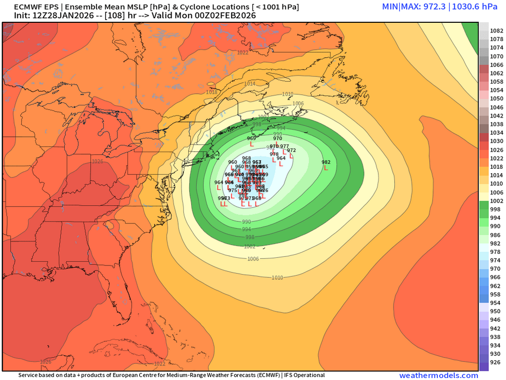
-

Possible coastal storm centered on Feb 1 2026.
ma blizzard replied to Typhoon Tip's topic in New England
can't wait for that inevitable run of the NAM that shows a region wide blizzard followed by a clean whiff within a couple model cycles