All Activity
- Past hour
-
Parts of the area also got snow on 12/5/2003. That was back when N&W suburbs meant something. I had like 8" in Germantown and rode the MARC to DC for work and it was wet ground there
-
A good trend that Wakefield extended the WWA SE to include the Peninsula. Hopefully they extend it SE more tonight.
-
My 4 model blend increased from 1.6" at 8 am to 2.4" at 1 pm.................... I will predict 2 - 4 inches for Augusta in my newsletter a little later, with snow developing 1 - 3 am. For D.C., my thoughts are .5" - 1.0" with flurries by 5 - 6 am.
-
Treating roads has begun here in the tropics
-
Moisture trying to make it down. 40/23. I've seen 4 flakes so far. LOL!
-
It’s because it’s happening in the morning during the commute.
-
18z HRRR is running, looks similar to 12z at hour 14.
-
Wasting money or brining... They have only been brining the roads for the last 15 years or so. Also, anyone that think the brine is beet juice or anything else... It is 77% water and 23% salt... so just another way to ruin our vehicles.
-
Congratulations Terp.!!
-

Winter 2025-26 Medium/Long Range Discussion
Chicago916 replied to michsnowfreak's topic in Lakes/Ohio Valley
Winter "MCS" szn -
They have been doing this for ages, good luck getting them to stop wasting the taxpayers money.
-
Looks like southern DE or the southern peninsula near Exmore will be a good chasing spot.
-

Winter 2025-26 Medium/Long Range Discussion
A-L-E-K replied to michsnowfreak's topic in Lakes/Ohio Valley
clippers really are baroclinic systems at the end of the day -
Why because I think it is dumb that they are brining the roads and wasting tax payer's money?
-

December 2025 Short/Medium Range Forecast Thread
Carvers Gap replied to John1122's topic in Tennessee Valley
What I see from the 12z GEPS and EPS is very cold air in Canada that keeps pinwheeling into the US old school style. And that setup is a very stable pattern unlike other cold patterns we have seen. JB noted that wave lengths tend to shorten up during phase 8 and wx models will often struggle with details and strength of cold shots. If we kind of assumed this pattern began just after Thanksgiving, it makes sense for it to last to Christmas or just after, then Jan is likely warm, followed by another cold shot. This set-up reminds me a lot of 95-96 in terms of the overall sequence(maybe not the snow). Last winter did as we'll. -
2002, 2005, 2007 and 2009.
-
Geographically Bellayre is souther NY state. It's weird how the population of New York views everything 30 miles north of where they live as upstate. Binghamton is the southern tier of New York and that area is referred to as such on thruway maps, yet 90% of the residents of NY view it as way the hell upstate.
-
More Tik Tok rescues?
-

Richmond Metro/Hampton Roads Area Discussion
chris624wx replied to RIC Airport's topic in Mid Atlantic
I guess I'll just be happy to see flakes flying. Doesn't look like anything to get real excited about down this way. Hope everyone away from the coast cashes in! -
December 2025 Short/Medium Range Forecast Thread
Carvers Gap replied to John1122's topic in Tennessee Valley
The Euro, after stumbling and bumbling for 4-5 days(losing the pattern), has a reasonable transition of the MJO. I think it just keeps rotating around. The GFS/AmericanModeling has tried to loop it around and been wrong with that on multiple occasions. Does it stall? It may. To me, this looks like it will transit cold phases, go COD 3-5, exit into a strong 6, and come right back around. The GEPS and EPS looks decent in the long range. The GEFS keeps pushing back the flip. I do think we see a ridge(maybe???). -

December 2025 regional war/obs/disco thread
powderfreak replied to Torch Tiger's topic in New England
All joking aside, these are some truly rugged conditions outside at the mountain. Full-on whiteouts and howling wind. Even the ASOS in the valley is registering the rare M1/4 under quarter mile vis… METAR KMVL 041825Z AUTO 34015G21KT M1/4SM +SN VV009 M08/M11 -
-

Winter 2025-26 Medium/Long Range Discussion
hawkeye_wx replied to michsnowfreak's topic in Lakes/Ohio Valley
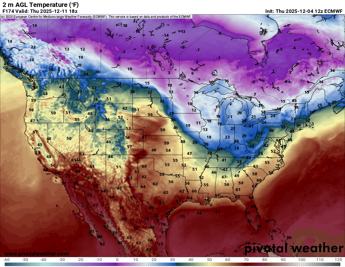
It's a very active pattern over the next couple weeks. There will be an alternating series of brief mild and cold surges. The Euro is showing quite a temp contrast a week from now between the plains and lakes.
-
Oh look, another attempt at a warm up (after next weekend) that looks muted all of a sudden... Op runs are super active, if northern stream dominated (as expected).
-
Moving to by far the warmest part of NY state didn't help. I realize it would mean commuting but living 40 miles north of midtown makes a world of difference.