All Activity
- Past hour
-

Central PA Spring 2026 Discussion/Obs Thread
Ruin replied to Voyager's topic in Upstate New York/Pennsylvania
Yep its way off it hasnt really been updated in like 2 months at least. I got close to 1.00 of rain in the last week that would put us even for the year. -
Given the sfc low tracked/developed right over SNE, are you surprised? Scott needs to look up his 700 low track rule for dry slots!
-
So WSR-88Ds can now go as low as 0.3 deg for BREF1?
-
One other thing, and this is biggie. The NAM has always been useless when it comes to TCs. It sucks w/ track and intensity, doing all sorts of odd things. It never was designed to handle TCs. The HRRR seems to handle TCs well, and no reason to think the RRFS will not be the same. I'll check further on this. Everyone seems focus on the negative for the "new stuff," but leaves out the shortcomings of the present, like the NAM guidance, that has sig drawbacks. One thing I will miss, the NAM MOS handles low-level cold air much better than the GFS MOS. Which brings me to another point, is there MOS-type output for other models, CAM and global? If so, what is a good site to view it? W/ NAM MOS going away, more and more will likely just look at 2 m temps (some do already), and run w/ them -- not good in the longer ranges!
-
CoastalWx *demands* a Weymouth specific fcst!!! LOL.
-
So it seems that only the 24 hr state record was set. They noted 38" storm total at Woonsocket for the Blizzard of 78. So the PVD storm total falls just short of the state record it seems? If we had the degree of detail for observations in Feb 1978 like we do now, you'd very likely find lots of 40"+ amounts storm totals (Scott would see to that!) both in RI and eastern MA. 44" was reliably measured in an open field in Woburn MA, and from pix I have seen people shoveling out walkways and standing next to "snow walls" the morning of Feb 7, about 3 ft had already fallen, and it was S/S+ for another 12 hr or so in eastern MA.
-
Wasn’t expecting a watch this far east. Probably won’t even get here until 4-5am and I can’t imagine it’ll stay together but we’ll see. I’ll take a few rumbles even if that’s the most I get out of it.
-
1.91" last three days. Sun broke out early evening. Looking forward to a taste of summer.
-

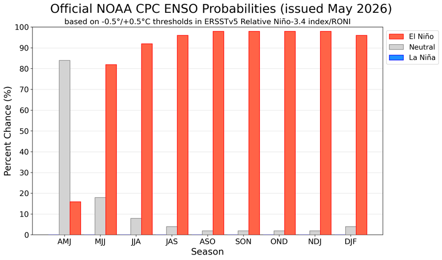
2026-2027 Strong/Super El Nino
PhiEaglesfan712 replied to Stormchaserchuck1's topic in Weather Forecasting and Discussion
-
KCTH - Eugene Island 338K LA 28.196 -91.667 44m KEOP - Waverly OH KLQR -Larned KS KNBJ - Foley AL
- Today
-
lol - Nats bullpen still likes to make things interesting.
-
Yeah I can't necessarily remember a consistent pattern like this where it goes from so warm to so cool each month of Spring. In April you had 90's then 20's. This week my forecast high on Tuesday is 98, then next Saturday it's 60..
-
May start drinking Pepsi to see if I can taste the sweat in it

-
Could see smoke from my house earlier today. Not seeing anything this evening. Hopefully this will get contained quick. Lake Superior is a natural barrier, so they can concentrate on areas that will impact property more. Was in the 80's today with very low RH. Awesome mid May day. Should be in the 70's tomorrow with a little less wind, but still a decent breeze. Thankfully lots of rain coming starting Sunday aftrn sometime.
-
Quite possibly the best symbolic metric for that is the fact that the nights won’t be nearly as cold. This will cause a healthy status of green up to go full on jungle by the end of the week. Frankly, I’m amazed green ups as far as it is the way it’s been dipping into 37 every night for the past 7000 years
-
While it was closer to 18C/65F today, it still felt cool and unwholesome out there with some patchy sun. I think around 1pm that's when it got mostly cloudy . Thurs it was 3pm the veil of despair smothered us. I find I feel unwell as soon as the veil of despair makes it over here. Tomorrow rain, just sickening.
-
Yep... Mayo still sucks
-
Just had a heck of a detour but made it to our campground. First time I’ve been personally impacted by wildfire like that
-
Wow! Escaped em all here in Southington. Twisters don’t like my town. And That’s fine by me.
-

E PA/NJ/DE Spring 2026 Obs/Discussion
mcwx replied to PhiEaglesfan712's topic in Philadelphia Region
Based on the 18z GFS, drought conditions are going to get worse -
Reading like the historical accts I post.
- Yesterday
-
Was south of Springfield 2 weeks ago and was commenting to a friend that I’ve never seen so much dust blowing around in Illinois before. The winds weren’t even all that strong. About an hour later we got a push alert on our phones for a dust storm warning. I don’t think I’ve ever had a push alert for that in Illinois before.
-
That was a wild day. Best structure I’ve seen in southern NE. My uncle got hit by the tornado on his way home from Waterbury. He had the rather extraordinary distinction of being hit directly by three tornadoes while living in SCT. House got smoked by the July ‘89 F4, then 2018 and 2020 (or was it ‘21?)
-
Had to cover everything again last night. Hopefully that's the final one for the season. The dry air is allowing free falling temps but it will also help get the heat going.
- 236 replies
-
- 2
-

-
- severe
- mountain snow
- (and 1 more)
-
So exciting!


.thumb.gif.f92b16c631a1d15d405ed77b33f0710d.gif)
