All Activity
- Past hour
-
Gonna have goofy storm/shower motions today
-
59 with heavy rain currently in Wolf. We've picked up 7.66" since midnight! Sent from my Pixel 10 Pro using Tapatalk
-
Wildfire sprouting in Brunswick county. It's been dry down there too.
-
I think most here have seen this article but the below peer reviewed study should calm many of the alarmist on this forum as both hot days and "heatwaves" and cold days are on the clear decline. This should continue to result in a decline in deaths due to climate impacts. https://link.springer.com/article/10.1007/s00704-026-06200-3
-
I remember it in West Chester, PA. I was 7.
-
(002).thumb.png.6e3d9d46bca5fe41aab7a74871dd8af8.png)
Central PA Summer 2026 Discussion/Obs Thread
ChescoWx replied to Voyager's topic in Upstate New York/Pennsylvania
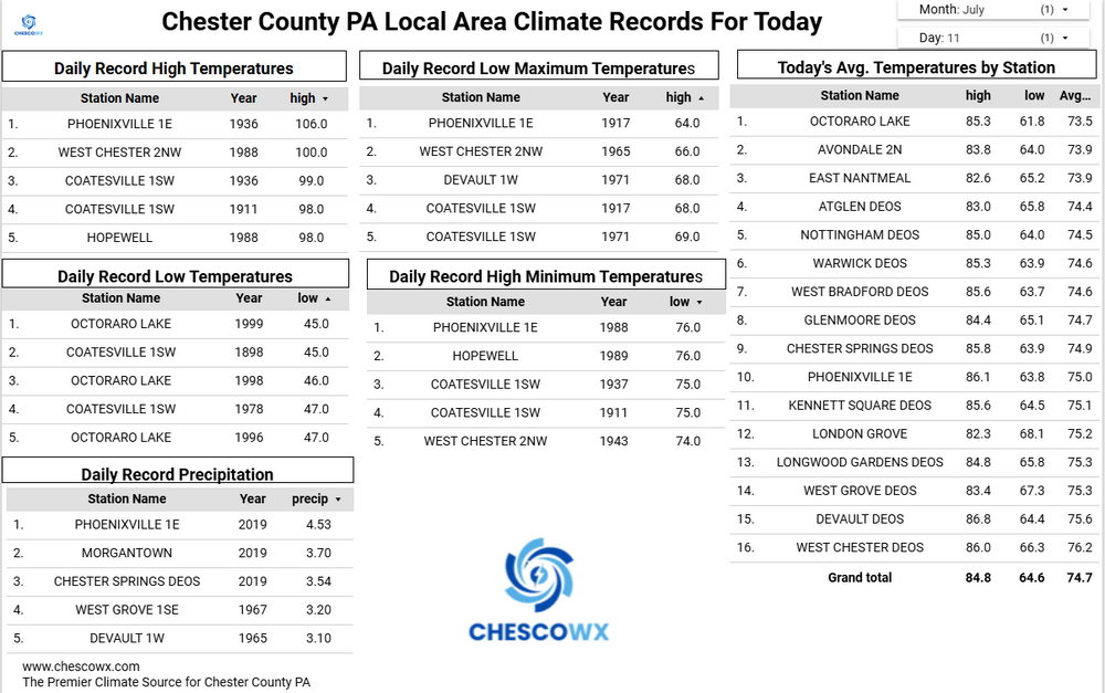
Rain chances increase again later this afternoon with the best chances between 3pm to 8pm. A couple beautiful days on tap both Sunday and Monday with temperatures slightly cooler than average for mid-July. We start a solid warm up on Tuesday and may see widespread 90+ temps for one day on Wednesday. Still hot but "only" in the upper 80's both Thursday and Friday.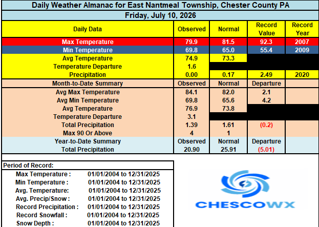
-
Central PA Summer 2026 Discussion/Obs Thread
ChescoWx replied to Voyager's topic in Upstate New York/Pennsylvania
I loved the unit but sadly I had 5 of them fail on me at the jersey shore - great customer service though as they replaced them every time. Finally gave up and went back to a vantage vue down the shore. I also have a poorly sited one at home in East Nantmeal it has run for 5 plus years but loses power now during cloudy winter days. -
 Apples and oranges. Dews… We know this. Miami is +7 to that temp in terms of real feel, heat index, while Denver is -5. So it’s really like 85 Denver, 97 Miami. Yea that checks out….
 -
E PA/NJ/DE Summer 2026 Obs/Discussion
ChescoWx replied to PhiEaglesfan712's topic in Philadelphia Region
Rain chances increase again later this afternoon with the best chances between 3pm to 8pm. A couple beautiful days on tap both Sunday and Monday with temperatures slightly cooler than average for mid-July. We start a solid warm up on Tuesday and may see widespread 90+ temps for one day on Wednesday. Still hot but "only" in the upper 80's both Thursday and Friday.
-
E PA/NJ/DE Summer 2026 Obs/Discussion
ChescoWx replied to PhiEaglesfan712's topic in Philadelphia Region
Nada in NW chesco too -

2026-2027 Super El Nino
SnoSki14 replied to Stormchaserchuck1's topic in Weather Forecasting and Discussion
Catastrophic outcome if that were correct -
 Mid to upper 90s again next week. What a summer.
 -

2026-2027 Super El Nino
TriPol replied to Stormchaserchuck1's topic in Weather Forecasting and Discussion
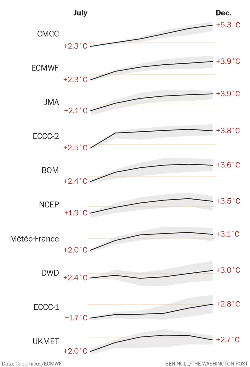
Lol @ CMCC. That would be such an extreme scenario.. but we're living in extreme scenarios right now.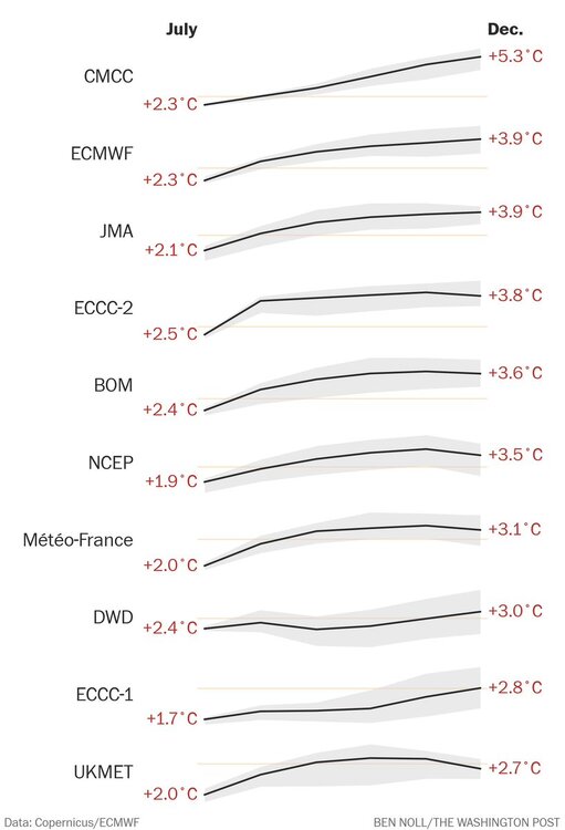
-

Central PA Summer 2026 Discussion/Obs Thread
canderson replied to Voyager's topic in Upstate New York/Pennsylvania
Another major heat dome will get dislodged by a powerful low. Rinse and repeat from last weekend. - Today
-
 Carol and Edna each dumped a lot of rain, but they were about a month apart. The next year Connie/Diane combined for 12-22" in 8-9 days over much of SNE. Of course, the 1954 hurricanes had far more wind.
 -
 Maybe by Oct
 -
Flood Advisory National Weather Service Morristown TN 939 AM EDT Sat Jul 11 2026 TNC059-063-073-171-179-111645- /O.NEW.KMRX.FA.Y.0073.260711T1339Z-260711T1645Z/ /00000.N.ER.000000T0000Z.000000T0000Z.000000T0000Z.OO/ Greene TN-Hamblen TN-Hawkins TN-Unicoi TN-Washington TN- 939 AM EDT Sat Jul 11 2026 ...FLOOD ADVISORY IN EFFECT UNTIL 1245 PM EDT THIS AFTERNOON... * WHAT...Flooding caused by excessive rainfall is expected. * WHERE...Central Greene County in east Tennessee... East Central Hamblen County in east Tennessee... South Central Hawkins County in east Tennessee... Southwestern Unicoi County in east Tennessee... Southwestern Washington County in east Tennessee... * WHEN...Until 1245 PM EDT. * IMPACTS...Minor flooding in low-lying and poor drainage areas. * ADDITIONAL DETAILS... - At 939 AM EDT, Doppler radar indicated heavy rain due to thunderstorms. Minor flooding is ongoing or expected to begin shortly in the advisory area. Between 1 and 2 inches of rain have fallen. - Additional rainfall amounts of 1 to 2 inches are expected over the area. This additional rain will result in minor flooding. - Some locations that will experience flooding include... Greeneville, Tusculum, Mosheim, Bulls Gap, Camp Creek, Chucky, Davy Crockett Birthplace, Limestone, Romeo and Rocky Fork. - http://www.weather.gov/safety/flood PRECAUTIONARY/PREPAREDNESS ACTIONS... Turn around, don`t drown when encountering flooded roads. Most flood deaths occur in vehicles. In hilly terrain there are hundreds of low water crossings which are potentially dangerous in heavy rain. Do not attempt to cross flooded roads. Find an alternate route. Flooding is occurring or is imminent. It is important to know where you are relative to streams, rivers, or creeks which can become killers in heavy rains. Campers and hikers should avoid streams or creeks. && LAT...LON 3625 8315 3634 8300 3627 8271 3623 8260 3613 8247 3604 8244 3601 8246 3598 8251 3597 8254 3595 8256 3597 8261 3599 8260 3600 8261 3603 8259 3605 8262 3607 8263 3602 8273 3613 8288 3619 8313 $$
-
Some areas of Greene & Cocke Co this morning have received tremendous amounts of rain, frequent lightning as well. My weather station is reporting 1.3" at my location but I also think it's not collecting right cause weather stations within a mile have almost a .75 inch deviation
-
Darkness falls upon parts of my south again. Looks like southern Hudson county goi g get a nice line of thunderstorms.
-
 Let’s keep fixing problems by treating the symptoms and not the cause https://www.newscientist.com/article/2533348-seeding-clouds-with-seawater-could-prevent-a-super-el-nino/
 -
Would love a week of rain.
-
 Fine looking summer week upcoming. Of course the nuts will want rain instead.
 -
I was working night shift in a warehouse in Savage, MD in Feb ‘83. The snow began while we were working. Before leaving, I asked the boss “if it snows all day, are we working tonight?” He told me emphatically that we didn’t close for snow. Having grown up in Western Md. where we rarely closed for snow, I took him at his word. That evening, I swept 2’ of snow off my driveway (didn’t own a shovel) and dutifully drove to work. Only to find the place deserted and 4’ drifts against the door.
-

Central PA Summer 2026 Discussion/Obs Thread
Itstrainingtime replied to Voyager's topic in Upstate New York/Pennsylvania
I can't get excited because I have zero interest in anything that causes damage. -

Central PA Summer 2026 Discussion/Obs Thread
Voyager replied to Voyager's topic in Upstate New York/Pennsylvania
I can't get excited about severe threats because they never materialize in my local vicinity.