All Activity
- Past hour
-
Next week looks like ass.
-

Chester County PA - Analytical Battle of Actual vs. Altered Climate Data
chubbs replied to ChescoWx's topic in Climate Change
The deep dive in Chester County has made me very suspicious of older high temperature records. Non-aspirated thermometers used back in the day are sensitive to shelter placement. Only takes one poorly sited station on one day to ruin a max temperature statistic. Phoenixville in Chester County is a good example. Much hotter max temperatures than surrounding stations for 20 years in the 1930s and 40s. The records in Chester County are very misleading because modern stations are much cooler than Phoenixville during its warm period. The other old stations in Chesco were also warmer than the county average. This whole thread is a giant cherry pick of misleading data and analysis methods. -
High of 88 yesterday, and picked up another 1/2" of rain in the afternoon in a T-Storm. Should be rain free the next couple of days, with T-storms returning for the weekend.
- Today
-
Christmas in July starting soon on the Hallmark channel.
-
Yes cancel winter in June. Thats the spirit .
-
Hopefully some folks see triple-digit heat indexes!
-

Junorch obs and discussion 2026
CT Valley Snowman replied to Damage In Tolland's topic in New England
Heat advisories are up. Bring it on. -
Today's Highs: EWR: 85 TEB: 84 BLM: 83 New Brnswck: 83 TTN: 82 PHL: 82 LGA: 81 ACY: 80 NYC: 79 ISP: 76 JFK: 75
-
Eastern Iowa is gonna get hammered early tomorrow evening with the main wave. Looks like Thursday action may focus more along and south of I-80 due to the morning wave. That morning/early afternoon batch will be severe as well, but may push the main show further south in the later afternoon.
-

E PA/NJ/DE Spring 2026 Obs/Discussion
KamuSnow replied to PhiEaglesfan712's topic in Philadelphia Region
@RedSky I know you're into insects, and I thought of you earlier when I saw this watermelon my wife picked up. (lol).jpg.cfd719f64ce15acc02116d1598b35ed7.jpg)
-

2026-2027 Super El Nino
Stormchaserchuck1 replied to Stormchaserchuck1's topic in Weather Forecasting and Discussion
^Only other period on record to have 5/6 La Nina's, until 2020-2026 (RONI): 20-21: Moderate La Nina 21-22: Moderate La Nina 22-23: Moderate La Nina 23-24: Moderate El Nino 24-25: Moderate La Nina 25-26: Weak La Nina ENSO tends to even out, historically. Here is what followed the 70-76 streak: 76-77: Moderate El Nino 77-78: Moderate El Nino 78-79: Neutral 79-80: Weak El Nino 80-81: Neutral 81-82: Neutral 82-83: Super El Nino Really interesting that we didn't see another La Nina for 7 years after 70-76. Climate Prediction Center - Relative Oceanic Niño Index (RONI) 07-12 was 4/5 La Nina's, then didn't see another one for 4 years, and 3 years later 15-16 was Super El Nino. 86-95 was 4 El Nino's vs 1 La Nina, and was followed by 4/6 La Nina's. 95-01 was 4 La Nina's vs 1 El Nino, and flipped to 2 El Nino, 2 Neutral, 0 La Nina's for 4 years, and the 97-98 Super El Nino was in there. ENSO "evening out" is the theme. It would be interesting to see if pre-1948 followed the same pattern. *The 76-83 4 El Nino vs 0 La Nina was followed by only 2 El Nino's in the following 8 years in +PDO, and the Strongest La Nina on record (88-89) occurred in that period. -

2026-2027 Super El Nino
PhiEaglesfan712 replied to Stormchaserchuck1's topic in Weather Forecasting and Discussion
72-73 was followed by a strong la nina (part of a triple la nina), and preceded by a double la nina: 1970-71 - moderate la nina 1971-72 - weak la nina 1972-73 - super el nino 1973-74 - strong la nina 1974-75 - weak la nina 1975-76 - strong la nina -
Deep -PDO continues (time sensitive)
-
Can't it just be ok to have upper upper 70's and low 80's?
-
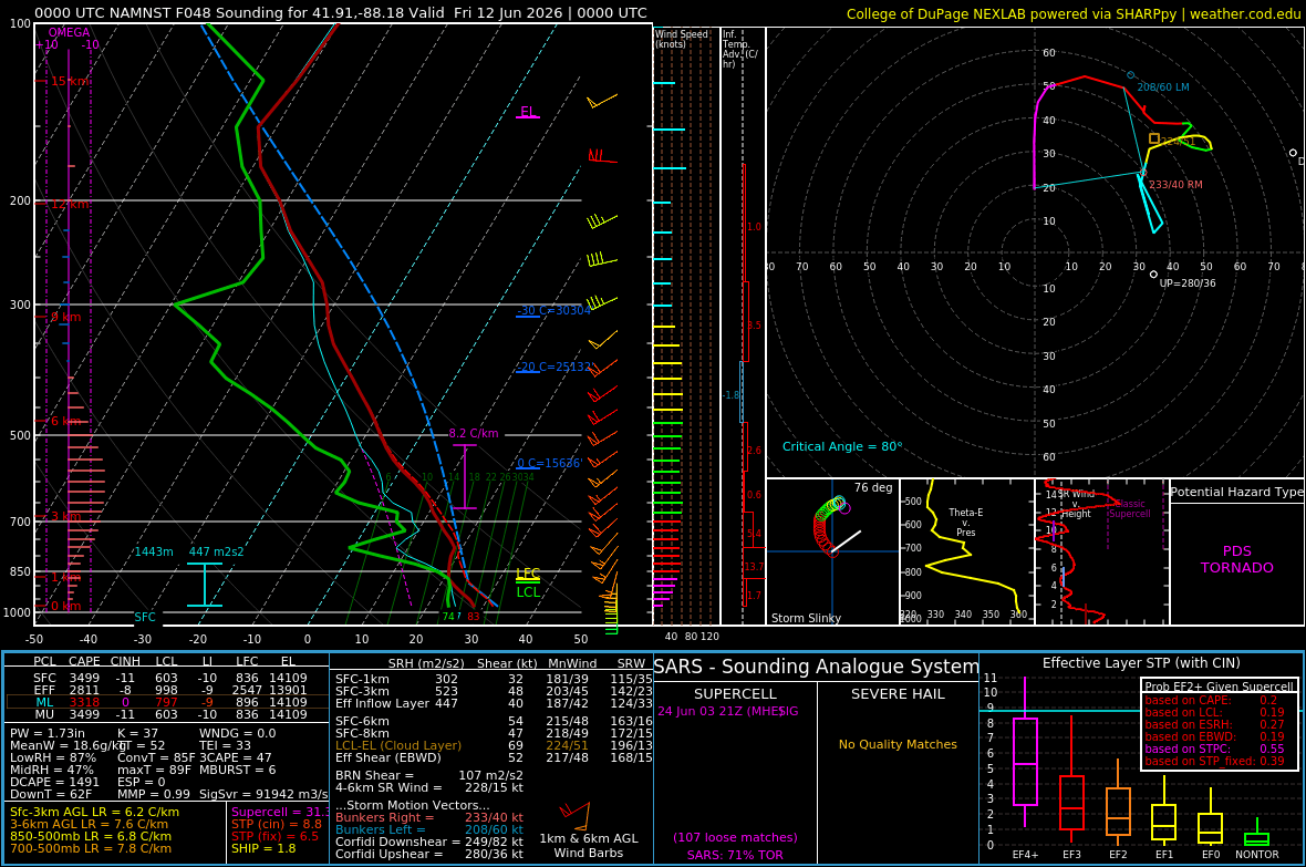
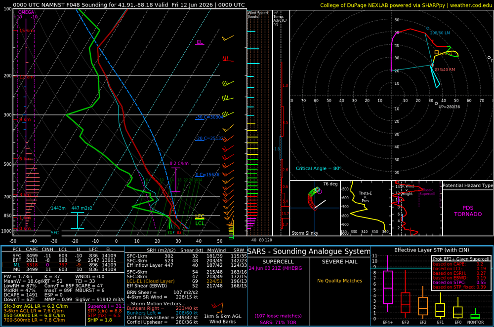
Boy howdy, this is one loaded sounding from 3knam for me:
-

Pittsburgh PA Summer 2026 Thread
Mailman replied to TheClimateChanger's topic in Upstate New York/Pennsylvania
EF1 about 3-4 miles from here. Crazy. -
watching the plains outbreak - some of those cell mergers in NE are wild
-
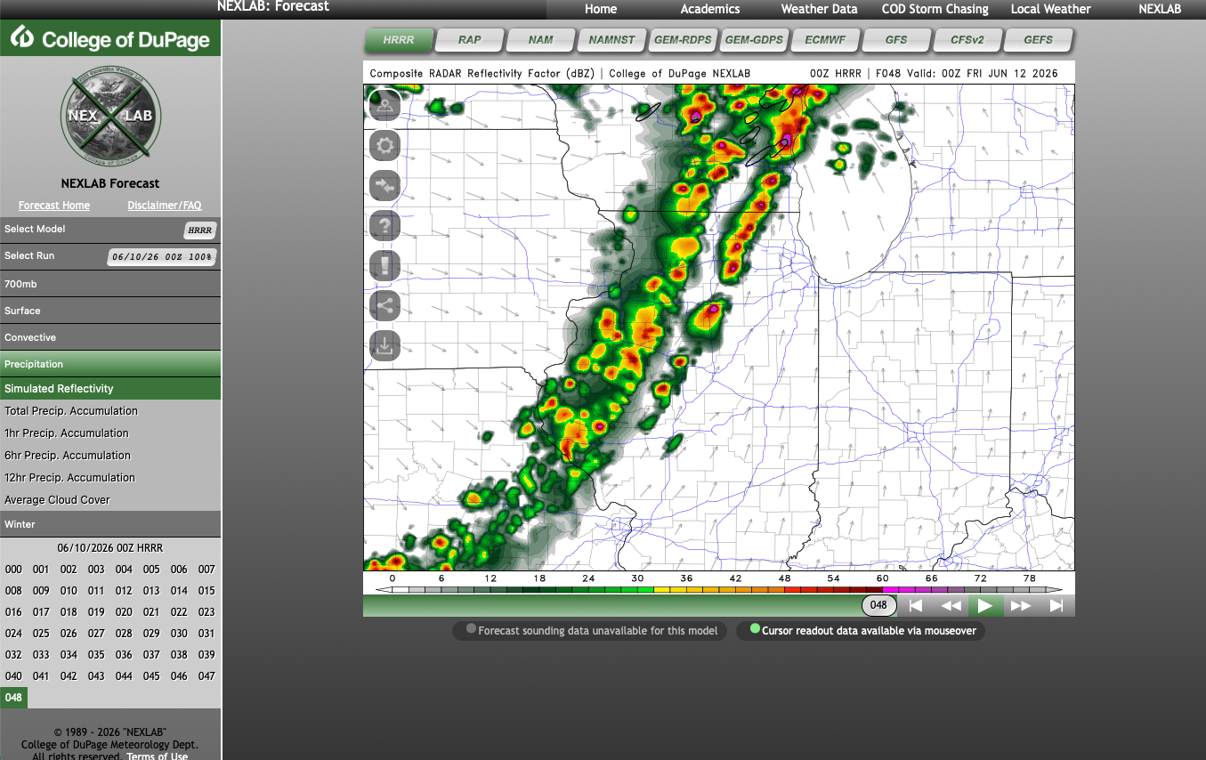
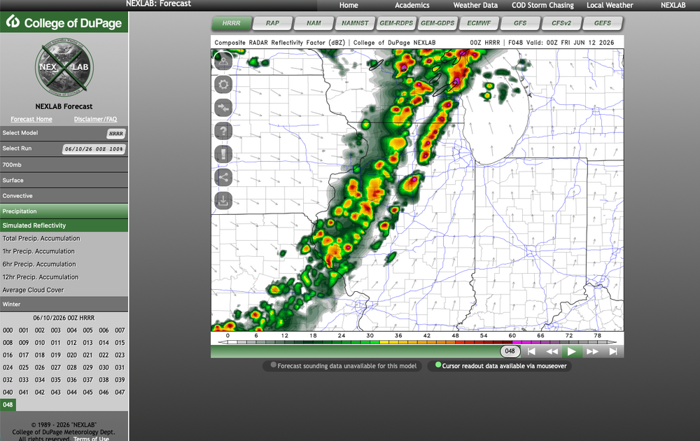
HRRR for tomorrow
-
Late May/June 2026 Medium/Long Range
Stormchaserchuck1 replied to JenkinsJinkies's topic in Mid Atlantic
Long range 18z GEFS @384 hr has us as one of the coldest spots in the N. Hemisphere, matching historical ENSO analogs -
Model sounding here for 18z is nearly 5000 SBCAPE with minimal to no capping, 87/76 T/Td, and PWAT of 2 inches. Charged! Already felt quite juicy out tonight.
-
Are you referring to Thursday? Because I am seeing/wondering same. The convection isn't quite as large/robust at the very end of run but a bit more discrete than earlier models
-
Am I reading this wrong, but does the HRRR also want to keep things discreet going into the metro?
-
There were some bands of virga with nearly nothing so no 10mm at 5pm, now its 9 where I was suppose to get heavy storms; I see overcast and now light showers . For nearly a week out 2 agencies forecasting storms all aft and eve, and I don't even hear thunder. Storms nixed for Weds as well. I love these busts.
-
45F to 85F today… nice crisp morning, followed by deep summer mid-80s. Fantastic day.
-
Thanks. Its the best. Still unpacking but getting there Stay cool in the heat!


.thumb.gif.f92b16c631a1d15d405ed77b33f0710d.gif)