Syrmax Posted February 6, 2020 Share Posted February 6, 2020 31 minutes ago, wolfie09 said: I'm actually just in the"pink" like most of Oswego county lol I live in NW Altmar/Richland.. It's the thought that counts here. Link to comment Share on other sites More sharing options...
Thinksnow18 Posted February 6, 2020 Share Posted February 6, 2020 19 minutes ago, OSUmetstud said: They'll wait for the ecmwf and for the normal 4 pm package id think. I think Monroe to Oswego county is a given. Erie and Niagara is still more on the fence. OSU im nowhere near your level of expertise, but given where I live in Williamsville close to Clarence, I can say with good confidence that lake enhancement off Ontario makes it to me quite frequently but models NEVER pick up on it. They stop right at the Niagara/Erie border like there's a magic wall there. The storm in November was a perfect example of this as we bested the amount we were forecast by 3 or 4 inches due to the enhancement. I think N. Erie is going to overachieve again. Link to comment Share on other sites More sharing options...
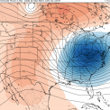
OSUmetstud Posted February 6, 2020 Share Posted February 6, 2020 Euro is going to be good in think. Southern shortwave is sharper and more negative compared to 06z and 00z runs. Link to comment Share on other sites More sharing options...
Syrmax Posted February 6, 2020 Share Posted February 6, 2020 Hancock field had 31 degrees as of noon but downtown i don't see any ice forming on cars, signs, in the steady drizzle, so perhaps the urban heat island is helping us avoid frozen windshield wipers. For now... Link to comment Share on other sites More sharing options...
wolfie09 Posted February 6, 2020 Share Posted February 6, 2020 Yeah, looks a good deal better.. Link to comment Share on other sites More sharing options...
96blizz Posted February 6, 2020 Share Posted February 6, 2020 3 minutes ago, OSUmetstud said: Euro is going to be good in think. Southern shortwave is sharper and more negative compared to 06z and 00z runs. Appreciate the PBP and really great to see the forum so active this week!! bring it home!! Link to comment Share on other sites More sharing options...
TugHillMatt Posted February 6, 2020 Share Posted February 6, 2020 29 minutes ago, BuffaloWeather said: Steady Freezing rain here right now. Encase that snowpack with some frozen preservent! Link to comment Share on other sites More sharing options...
OSUmetstud Posted February 6, 2020 Share Posted February 6, 2020 Link to comment Share on other sites More sharing options...
TugHillMatt Posted February 6, 2020 Share Posted February 6, 2020 Wow, the international models look FANTASTIC for the Syracuse area. Someone remind me not to get too excited. Still have over 24 hours... Link to comment Share on other sites More sharing options...
96blizz Posted February 6, 2020 Share Posted February 6, 2020 Just now, OSUmetstud said: Time to hoist the warnings! Link to comment Share on other sites More sharing options...
CNY_WX Posted February 6, 2020 Share Posted February 6, 2020 9 minutes ago, Syrmax said: Hancock field had 31 degrees as of noon but downtown i don't see any ice forming on cars, signs, in the steady drizzle, so perhaps the urban heat island is helping us avoid frozen windshield wipers. For now... I’m sure downtown is a couple degrees warmer than the airport plus solar radiation is starting to become more significant since we’re a week into February. Link to comment Share on other sites More sharing options...
wolfie09 Posted February 6, 2020 Share Posted February 6, 2020 5 minutes ago, TugHillMatt said: Wow, the international models look FANTASTIC for the Syracuse area. Someone remind me not to get too excited. Still have over 24 hours... Yeah it's funny because the gfs looked great couple days ago and the NAM yesterday, both abandoned ship lol Wait till the NAM figures it out lol Link to comment Share on other sites More sharing options...
wolfie09 Posted February 6, 2020 Share Posted February 6, 2020 15 minutes ago, Syrmax said: Hancock field had 31 degrees as of noon but downtown i don't see any ice forming on cars, signs, in the steady drizzle, so perhaps the urban heat island is helping us avoid frozen windshield wipers. For now... Torching up here lol Not much in the way of precip though.. Link to comment Share on other sites More sharing options...
CNY_WX Posted February 6, 2020 Share Posted February 6, 2020 I wonder if local media meteorologists will up their forecast amounts based on the 12Z runs. Right now most of them are calling for 4-8 inches after the changeover tomorrow morning. Link to comment Share on other sites More sharing options...
rochesterdave Posted February 6, 2020 Share Posted February 6, 2020 OSU what are your thoughts on Lake Placid? Link to comment Share on other sites More sharing options...
LakeEffectKing Posted February 6, 2020 Share Posted February 6, 2020 Hey everyone. Haven't been posting a ton, lots of life going on. This event looks great for most of Upstate.... my largest concern for big snow totals is if there is a ton of convection to the east of the storm track... will it rob some of the moisture being thrown back into the frontogenical forcing?.... Link to comment Share on other sites More sharing options...
vortmax Posted February 6, 2020 Share Posted February 6, 2020 38 minutes ago, wolfie09 said: Yeah, looks a good deal better.. 11mb drop in 6hrs? Bombogenesis territory. Link to comment Share on other sites More sharing options...
wolfie09 Posted February 6, 2020 Share Posted February 6, 2020 If the euro/uk/Ggem verified than these numbers would be a little low imby..But a solid start.. Link to comment Share on other sites More sharing options...
PaulyFromPlattsburgh Posted February 6, 2020 Author Share Posted February 6, 2020 HRRR and RGEM both showed this Nice light mesoscale banding that has been forming in Plattsburgh last several hours allowing no real break to really occur. Will measure once out of class. Prob close to 2 inches ATM Light snow Link to comment Share on other sites More sharing options...
vortmax Posted February 6, 2020 Share Posted February 6, 2020 Anyone know if the meso models compensate for abnormally high lake temps when calculating Lake Enhancement potential? Just wondering if the S Shore is in for an additional 'boost' due to this... Link to comment Share on other sites More sharing options...
CNY-LES FREAK Posted February 6, 2020 Share Posted February 6, 2020 Rain from now till well after midnight so we all might as well say goodbye to the snow we got overnight, lol!Sent from my SM-G970U using Tapatalk Link to comment Share on other sites More sharing options...
Geez150 Posted February 6, 2020 Share Posted February 6, 2020 7 minutes ago, CNY-LES FREAK said: Rain from now till well after midnight so we all might as well say goodbye to the snow we got overnight, lol! Sent from my SM-G970U using Tapatalk Figures Link to comment Share on other sites More sharing options...
vortmax Posted February 6, 2020 Share Posted February 6, 2020 8 minutes ago, CNY-LES FREAK said: Rain from now till well after midnight so we all might as well say goodbye to the snow we got overnight, lol! Sent from my SM-G970U using Tapatalk Don't you mean FRZ? Link to comment Share on other sites More sharing options...
wolfie09 Posted February 6, 2020 Share Posted February 6, 2020 Upgraded to warning as expected WINTER WEATHER ADVISORY REMAINS IN EFFECT UNTIL 6 PM EST THIS EVENING... ...WINTER STORM WARNING IN EFFECT FROM 6 PM THIS EVENING TO 6 AM EST SATURDAY... * WHAT...For the Winter Storm Warning, mixed precipitation through the early overnight hours, then heavy snow expected. Total snow accumulations of 8 to 15 inches and ice accumulations of up to one tenth of an inch, with winds gusting as high as 35 mph later tonight and Friday. For the Winter Weather Advisory, freezing drizzle with additional ice accumulations of a few hundredths of an inch. * WHERE...The Eastern Lake Ontario Region. * WHEN...For the Winter Storm Warning, from 6 PM this evening to 6 AM EST Saturday. For the Winter Weather Advisory, until 6 PM EST this evening. Link to comment Share on other sites More sharing options...
Thinksnow18 Posted February 6, 2020 Share Posted February 6, 2020 Downgraded to a winter weather advisory for 5 to 10 inches...still good I guess... Link to comment Share on other sites More sharing options...
CNY_WX Posted February 6, 2020 Share Posted February 6, 2020 020 ...WINTER STORM WARNING IN EFFECT FROM 10 PM THIS EVENING TO MIDNIGHT EST FRIDAY NIGHT... * WHAT...Heavy mixed precipitation expected. Total snow accumulations of 6 to 9 inches and ice accumulations of up to one tenth of an inch. * WHERE...Seneca, Southern Cayuga, Onondaga, Tompkins, Madison and Cortland counties. * WHEN...From 10 PM this evening to midnight EST Friday night. 2 minutes ago, Thinksnow18 said: Downgraded to a winter weather advisory for 5 to 10 inches...still good I guess... We’re under a WSW and KBGM is calling for less snow than you! SMH Link to comment Share on other sites More sharing options...
Syrmax Posted February 6, 2020 Share Posted February 6, 2020 Steady actual rain downtown SYR now. Temp at 32 -33 degrees throughout area. No ice forming. This will chew into storm totals if looking at total qpf. Link to comment Share on other sites More sharing options...
Buffalo Bumble Posted February 6, 2020 Share Posted February 6, 2020 25 minutes ago, Thinksnow18 said: Downgraded to a winter weather advisory for 5 to 10 inches...still good I guess... I hope we get there, but gotta say the seasonal trend of fast flow, sheared storms zipping along fronts, and lack of wraparound snow worries me. I say that just from what we’ve seen for weeks on end, this storm I’m sure has more going for it. Although if I was just looking at the current radar and surface maps I wouldn’t be too excited for WNY... Pay no mind to me though, I was walking along the beach in Jupiter, FL this morning (business trip) with temps in low 80’s and full sun...I’m having a hard time processing the walk to a snow/ice covered car at the airport in a couple hours. Link to comment Share on other sites More sharing options...
Revracer800 Posted February 6, 2020 Share Posted February 6, 2020 Steady rain here in Hannibal also. Temp is at 34. Link to comment Share on other sites More sharing options...
vortmax Posted February 6, 2020 Share Posted February 6, 2020 We're just below 32 so FRZ here. Link to comment Share on other sites More sharing options...

Recommended Posts
Archived
This topic is now archived and is closed to further replies.