Derecho! Posted August 23, 2012 Share Posted August 23, 2012 It absolutely is NOT the LLC. The radar is scanning at about 26kft at that location (above 500mb). It is about .3 degrees S of the advisory LLC position. Eh, poor choice of words - meant correlated with the LLC, which while it doesn't seem perfect (based on the wind shift from S to SSW from the last dropsonde from 10,000 feet) but at least seems to be getting smaller. Last two dropsondes bracketed the LLC, seems like a tighter circulation with 1005 mb and a 23 kt East Wind at 16N 65W, and 1007 mb and a 40 kt SSW wind at 15.2N 65W Link to comment Share on other sites More sharing options...
wxsmwhrms Posted August 23, 2012 Share Posted August 23, 2012 This could be something to keep an eye on the next few days. The top CIPS analogs at 96 hours in the SE domain, with good matches for scores, are for Katrina, Rita and Georges. After 96 hours the score matches become very poor (anything below a 10 for the total score is not good). Just something to watch. The webpage for CIPS is: http://www.eas.slu.edu/CIPS/ANALOG/WARM/analog.php Link to comment Share on other sites More sharing options...
wxmx Posted August 23, 2012 Share Posted August 23, 2012 According to the 0z and 06z GFS, the jog NW should have started by now...showing the low level vortex around 16N at 12UTC (a couple hours ago)...but it ain't happening soon, IMO. There's a whole lot of convection mass south of 15N, which will drag the circulation S of 16N for a little while more. Link to comment Share on other sites More sharing options...
IsentropicLift Posted August 23, 2012 Share Posted August 23, 2012 Early 12z guidance Link to comment Share on other sites More sharing options...
DaculaWeather Posted August 23, 2012 Share Posted August 23, 2012 Much better presentation this morning on the Funktop IR loop http://www.daculaweather.com/4_carb_ft_loop.php Link to comment Share on other sites More sharing options...
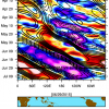
wxsmwhrms Posted August 23, 2012 Share Posted August 23, 2012 The latest experiemental GFS/EnKF track forecast: Link to comment Share on other sites More sharing options...
phil882 Posted August 23, 2012 Share Posted August 23, 2012 Its exceptionally hard to figure out where the circulation is using the NOAA P3 because its so poorly organized / displaced at 700 hPa which is the level they are flying. The Air Force WC-130J has been flying around 850 hPa, and their obs were very telling before they departed. Note last VDM was made just before 8am EDT. Link to comment Share on other sites More sharing options...
bubba hotep Posted August 23, 2012 Share Posted August 23, 2012 The latest experiemental GFS/EnKF track forecast: Here is the 00z Link to comment Share on other sites More sharing options...
wxmx Posted August 23, 2012 Share Posted August 23, 2012 Its exceptionally hard to figure out where the circulation is using the NOAA P3 because its so poorly organized / displaced at 700 hPa which is the level they are flying. The Air Force WC-130J has been flying around 850 hPa, and their obs were very telling before they departed. Note last VDM was made just before 8am EDT. NOAA P3's dropsondes indicate the low level center was between 15.27N and 16N...which would indicate a slight WNW to NW trajectory wrt to the last Air Force's VDM. The 700mb was closer to 15.3N Link to comment Share on other sites More sharing options...
NavarreDon Posted August 23, 2012 Share Posted August 23, 2012 Interesting in that typically storms approaching the northern coast of the GOM tend to start ingesting dry, continental-origin air as they near the coast. If the trough leaves the storm behind, it would cause a stall or very slow movement. But I'm not sure what impact this would have on dry air entrainment and all other things equal, the strength of the system as it crosses the coast. I guess I just remember the "worst case scenario" as being a slow moving cat 5 on a major metro area, but I wonder with the dry air issue if a storm can be both very strong AND slow moving at the same time. ? Seems difficult to achieve this combination. Just catching up on this thread & maybe headed down if the Panhandle becomes more likely as I have interests in the area. Don't know much about the dry air but I can tell you from experience that slow moving storms will weaken due to upwelling in this area. The N Gulf is deeper inshore than most parts however, once at about 20 KM from shore the shelf rises rather quickly to about 150 ft. By 15 KM it is around 80-100 ft. The surface water is rather warm 85°-88° but the turnover happens rapidly. This is in play with more intense storms...above Cat. 2. Smaller storms like Erin 1995 where not affected by this. Link to comment Share on other sites More sharing options...
phil882 Posted August 23, 2012 Share Posted August 23, 2012 The center is finally becoming a little more clear on radar... quickly tracking to the NW right now now, seems in line with the expected northward bend today. Link to comment Share on other sites More sharing options...
jconsor Posted August 23, 2012 Share Posted August 23, 2012 Buoy about 150 miles east of the center reported 35 kt 1-minute winds in the past hour. That suggests Isaac is probably a little stronger than the NHC advisory intensity. http://www.ndbc.noaa.gov/station_page.php?station=42060 Link to comment Share on other sites More sharing options...
NaoPos Posted August 23, 2012 Share Posted August 23, 2012 A questions for the mets or hardcore tropical enthusiasts. Isaac NE quad by 15-20N, and 55-60 W, there's up to 60knts of increased shear. Not directly near the storm , but it's causing some elongated outflow to the east. Is it possible for a storm (in one quadrant or as a whole system) to have too much outflow and disrupt the convective processes near the center? Link to comment Share on other sites More sharing options...
phil882 Posted August 23, 2012 Share Posted August 23, 2012 Buoy about 150 miles east of the center reported 35 kt 1-minute winds in the past hour. That suggests Isaac is probably a little stronger than the NHC advisory intensity. http://www.ndbc.noaa...p?station=42060 There were also a dropsonde that splashed down at 40 knots. Not sure why they kept 35 knots as the initial intensity. Link to comment Share on other sites More sharing options...
40/70 Benchmark Posted August 23, 2012 Share Posted August 23, 2012 Just catching up on this thread & maybe headed down if the Panhandle becomes more likely as I have interests in the area. Don't know much about the dry air but I can tell you from experience that slow moving storms will weaken due to upwelling in this area. The N Gulf is deeper inshore than most parts however, once at about 20 KM from shore the shelf rises rather quickly to about 150 ft. By 15 KM it is around 80-100 ft. The surface water is rather warm 85°-88° but the turnover happens rapidly. This is in play with more intense storms...above Cat. 2. Smaller storms like Erin 1995 where not affected by this. I don't think that the relatively shallow shelf waters, and the drier, continental air will play as large of a role in the landfall intensity of this system unless its a rather intense hurricane. Minimal hurricanes are not nearly as sensitive, nor difficult to sustain as major hurricanes are....think of most of the instances of what we term as "north gulf coast collapsers"......we are implying that they "collapsed" from their previous, manacing intesities. You need a nearly pristine enviornment to sustain a major hurricane.....however minimal hurricanes can exist under more hostile conditions. Link to comment Share on other sites More sharing options...
40/70 Benchmark Posted August 23, 2012 Share Posted August 23, 2012 Hopefully we are fortunate enough to worry about the aforementioned issues when the time comes, but that is putting the cart waaaaaay before the horse, at this stage.....we have a poorly stacked, minimal TS. Link to comment Share on other sites More sharing options...
Srain Posted August 23, 2012 Share Posted August 23, 2012 Beven is a very deliberate forecaster and my hunch is that he would like to see a bit more 'proof' that this will become the dominant COC. As he explained at Conference, he came darn close to upgrading Ike to a Major prior to landfall while observing multiple vorts within the 'eyewall' exceeding CAT 2 status and even a RECON report suggesting that. It just didn't last or sustain long enough to warrant an upgrade at that time. In the grand scheme of things, it makes little difference as Hurricane Warnings are hoisted for Hispaniola and further adjustments are expected as further data become more apparent. Link to comment Share on other sites More sharing options...
phil882 Posted August 23, 2012 Share Posted August 23, 2012 A questions for the mets or hardcore tropical enthusiasts. Isaac NE quad by 15-20N, and 55-60 W, there's up to 60knts of increased shear. Not directly near the storm , but it's causing some elongated outflow to the east. Is it possible for a storm (in one quadrant or as a whole system) to have too much outflow and disrupt the convective processes near the center? Well you need convection in the first place before you can get enhanced outflow.... the vertical wind shear generated from the storms low level flow vs. upper level flow is typically not a deterrent unless the storm is not vertically stacked, as the storm has been struggling with for the past few days. Link to comment Share on other sites More sharing options...
Ed Lizard Posted August 23, 2012 Share Posted August 23, 2012 A questions for the mets or hardcore tropical enthusiasts. Isaac NE quad by 15-20N, and 55-60 W, there's up to 60knts of increased shear. Not directly near the storm , but it's causing some elongated outflow to the east. Is it possible for a storm (in one quadrant or as a whole system) to have too much outflow and disrupt the convective processes near the center? Strong "shear" well away from the center, as part of the anticyclonic flow that develops near the center, isn't actually a bad thing. It is actually the beginning of outflow channels. Look at the bottom left panel attached below. What looks like hostile shear above Isaac and negative directed hostile shear below Isaac are developing outflow channels. Link to comment Share on other sites More sharing options...
wxmx Posted August 23, 2012 Share Posted August 23, 2012 The center is finally becoming a little more clear on radar... quickly tracking to the NW right now now, seems in line with the expected northward bend today. Beven is a very deliberate forecaster and my hunch is that he would like to see a bit more 'proof' that this will become the dominant COC. As he explained at Conference, he came darn close to upgrading Ike to a Major prior to landfall while observing multiple vorts within the 'eyewall' exceeding CAT 2 status and even a RECON report suggesting that. It just didn't last or sustain long enough to warrant an upgrade at that time. In the grand scheme of things, it makes little difference as Hurricane Warnings are hoisted for Hispaniola and further adjustments are expected as further data become more apparent. What I have been arguing above, is that although the LLC is currently moving WNW to NW, is that it can't detach of the massive convection to the south associated to the 700/500mb vortices...so this current movement might be part of a Fujiwhara interaction, so a bend toward the W to WNW is what I would expect...preventing Isaac from gaining more latitude. Models forecasted this well, but I think they underdid the strength of the mid level vorticity (enhanced by the continous strong convection, and the lack of it over the low level vortex), so the pivot of the interaction would be further south. I expect the vortices to coalesce around 16N, but a lot far west...and by a lot I mean closer to 70W, which would be a bit further south of the official track, with less Great Antilles interaction. Good thing is we have a new HH on the air to confirm or refute the above ideas. Edit: Probably 16N is too far south, after a second thought...closer to 16.5-17N maybe, moving WNW at the time. Link to comment Share on other sites More sharing options...
LakeEffectKing Posted August 23, 2012 Share Posted August 23, 2012 12z GFS is a tad quicker and further south (maybe missing the Shredder altogether) at 33 vs. prevous runs... Link to comment Share on other sites More sharing options...
Marion_NC_WX Posted August 23, 2012 Share Posted August 23, 2012 @ 114...storm about 100-125 or so miles west of Tampa and still moving Northwest...looks like it could landfall farther west than the 0z/6z runs... Link to comment Share on other sites More sharing options...
wxsmwhrms Posted August 23, 2012 Share Posted August 23, 2012 12z GFS is a tad quicker and further south (maybe missing the Shredder altogether) at 33 vs. prevous runs... It continues that leftward trend through period. It now passes near EYW and out through 114 it has already just passed the longitude of AQQ and it still only at TPA's latitude. Link to comment Share on other sites More sharing options...
PSUBlizzicane2007 Posted August 23, 2012 Share Posted August 23, 2012 So far the 12Z GFS track reminds me a lot of a weaker version of 2005-Dennis. Link to comment Share on other sites More sharing options...
Marion_NC_WX Posted August 23, 2012 Share Posted August 23, 2012 Coming ashore at 132 in the extreme western panhandle and still moving just west of due north... Link to comment Share on other sites More sharing options...
Marion_NC_WX Posted August 23, 2012 Share Posted August 23, 2012 At 141 in the extreme NW corner of the Florida Panhandle and moving into Southeast Alabama...big time rains spreading through Alabama and into Georgia EDIT: By 150 moving due north into Southeast Alabama...big rains extending as far northeast as Atlanta... Link to comment Share on other sites More sharing options...
hm8 Posted August 23, 2012 Share Posted August 23, 2012 ~990mb Pensacola hit on the 12z GFS, further west but weaker than the 00z. Link to comment Share on other sites More sharing options...
Superstorm93 Posted August 23, 2012 Share Posted August 23, 2012 If I didn't know any better, I'd say those center reports appear to be located in an outer band feature. This system really does not have the classic center displacement look that I have seen for years now. Instead, it looks like the heaviest convection is staying SW of the LLC and over the 700mb low. Is this really still that disorganized? EDIT: Spelling errors lol Link to comment Share on other sites More sharing options...
wxmx Posted August 23, 2012 Share Posted August 23, 2012 If I didn't know any better, I'd say those center reports appear to be located in an outer band. This system really does not have the classic center discernment look that I have seen for years now. Instead it looks like the heaviest convection is stating SW of the LLC and over the 700mb low. Is this really still that disorganized? Yes, and according to the 12z GFS the main low level vorticity should be just south of PR (17N) in less than 2 hours, though it shows the extreme tilt with height. I still think there will be some west adjustments with the track. Link to comment Share on other sites More sharing options...
dan11295 Posted August 23, 2012 Share Posted August 23, 2012 At this point I think it is a real possibility Isaac never really gets organized prior to interaction with Hispaniola/Cuba. What happens after is anyones guess. Could pull an Ernesto and get its act together rapidly at some point in the gulf. Link to comment Share on other sites More sharing options...

Recommended Posts
Archived
This topic is now archived and is closed to further replies.