dan88 Posted August 22, 2012 Share Posted August 22, 2012 15.7°N 62.2°W is the given 8pm position, .3 South and 1.0W of 5pm. Link to comment Share on other sites More sharing options...
Amped Posted August 22, 2012 Share Posted August 22, 2012 8pm advisory confirms a center hop to the WSW. Relocation appears to still be in progress with the H5 low to the SW of the surface low. Funny how these center hops on developing storms can make a huge impact on the eventual track and intensity of the cyclone. Link to comment Share on other sites More sharing options...
Superstorm93 Posted August 22, 2012 Share Posted August 22, 2012 15.7°N 62.2°W is the given 8pm position, .3 South and 1.0W of 5pm. Nice kink in the track now based on those coordinates. Probably will require some adjustment at 11pm. Link to comment Share on other sites More sharing options...
wxsmwhrms Posted August 22, 2012 Share Posted August 22, 2012 15.7°N 62.2°W is the given 8pm position, .3 South and 1.0W of 5pm. I noted that the 18Z GEFS actually lost its more SW members (toward the Yucatan) and gained a few again that go east of FL. Those members seem to go poleward relatively quickly and the fact that the center seems to be reforming more south this evening would seem to go against that idea. Link to comment Share on other sites More sharing options...
phil882 Posted August 22, 2012 Share Posted August 22, 2012 One negative for a more westward track is the very large size of the projected cyclone. A smaller TC in this sort of environment is much more easily controlled by the mid-level ridge in place. Since Isaac is already so large, the mid-level ridge is eroded more simply because the lower mid-level heights associated with the cyclone. Link to comment Share on other sites More sharing options...
Connor McCrorey Posted August 22, 2012 Share Posted August 22, 2012 The last couple of recon fly-throughs seem to indicate that the center of Isaac is still nudging a bit south of west. Considering that a significant portion of the latitude Isaac is forecast by NHC to gain prior to interaction with Hispanola takes place in the next few hours, I wonder if this short term trend will have some more significant long term impacts. Link to comment Share on other sites More sharing options...
Superstorm93 Posted August 22, 2012 Share Posted August 22, 2012 Nothing different so far with Isaac. Still a nice wedge of dry air intrusion and the same bursting pattern we have been seeing for the past few days. Low level vorts seem to be trying to get closer to the 500/700mb lows. (Looks like its moving a significant amount of air over SA) Link to comment Share on other sites More sharing options...
HurricaneJosh Posted August 23, 2012 Share Posted August 23, 2012 I think this SW relocation is very significant. It increases the possibility of 1) missing Shredderola, 2) missing S FL, and 3) impacting a further-N Gulf Coast location with greater intensity. Link to comment Share on other sites More sharing options...
Dsnowx53 Posted August 23, 2012 Share Posted August 23, 2012 Is it possible that what people are referring to in their polarward statement, whether they realize or not, is "beta drift" ?? Perhaps. A stronger storm with stronger windspeeds would have a higher coriolis, and thus more of a beta drift to the NW (as opposed to straight poleward). Not sure if this is to which they are referring, though. Link to comment Share on other sites More sharing options...
wxsmwhrms Posted August 23, 2012 Share Posted August 23, 2012 The last couple of recon fly-throughs seem to indicate that the center of Isaac is still nudging a bit south of west. Considering that a significant portion of the latitude Isaac is forecast by NHC to gain prior to interaction with Hispanola takes place in the next few hours, I wonder if this short term trend will have some more significant long term impacts. Looking at the way that W-E band of convection currently over and S of Guadaloupe on the 2315Z image is moving west, it would seem pretty clear that at least the circulation driving that motion is to the S or SW, meaning that the center has got to be reforming now pretty well S of 16N. Link to comment Share on other sites More sharing options...
Superstorm93 Posted August 23, 2012 Share Posted August 23, 2012 Recon menu for tonight. -USAF recon just left the system. -We have the NOAA research mission until 11:30 pm -USAF recon begins fixes at 1:30 am -NOAA Research mission begins at 5 am G-IV synoptic mission is scheduled for 1:30 pm tomorrow Link to comment Share on other sites More sharing options...
Connor McCrorey Posted August 23, 2012 Share Posted August 23, 2012 I think this SW relocation is very significant. It increases the possibility of 1) missing Shredderola, 2) missing S FL, and 3) impacting a further-N Gulf Coast location with greater intensity. Exactly. In addition, it looks like there's been a very intense burst of convection right over the center during the last couple of hours. I'd like to see some of that just a bit further south instead of piled on the N/E side of the center, but that convection will hopefully boost Isaac enough so that the E Caribbean/Hispanola don't just shred it into an open wave (not that I see that happening either way). Link to comment Share on other sites More sharing options...
Scott747 Posted August 23, 2012 Share Posted August 23, 2012 OPERATIONS Wednesday, Aug 22, 2012 NOAA-42: Is currently flying in Tropical Storm Isaac. This flight took of around 2000 UTC from Barbados and will land in Barbados. Comments: NOAA42 is flying a P-3 TDR mission. Three HRD scientists will be on this flight. Thursday, Aug 23, 2012 G-IV: Is scheduled around Tropical Storm Isaac. Take off will be at 1730 UTC from MacDill and will recover at MacDill. The G-IV will be sampling the subtropical ridge north of Isaac. No HRDers will be on this flight. NOAA-42: Scheduled for a tasked mission into Tropical Storm Isaac. Takeoff will be at 0800 UTC from Barbados and landing in Barbados. Comments: NOAA42 will fly a P-3 TDR mission into AL94. Three HRD scientists will be on this flight. Link to comment Share on other sites More sharing options...
Eyewall2005 Posted August 23, 2012 Share Posted August 23, 2012 18z GFDL still S.FL rather intense. Link to comment Share on other sites More sharing options...
HurricaneFrances04 Posted August 23, 2012 Share Posted August 23, 2012 Recon menu for tonight. -USAF recon just left the system. -We have the NOAA research mission until 11:30 pm -USAF recon begins fixes at 1:30 am -NOAA Research mission begins at 5 am G-IV synoptic mission is scheduled for 1:30 pm tomorrow Will the NOAA research mission help tonight's model data, or is it just tomorrow's G-IV? Link to comment Share on other sites More sharing options...
CUmet Posted August 23, 2012 Share Posted August 23, 2012 Looking at the way that W-E band of convection currently over and S of Guadaloupe on the 2315Z image is moving west, it would seem pretty clear that at least the circulation driving that motion is to the S or SW, meaning that the center has got to be reforming now pretty well S of 16N. Also interesting to note that this is the first time in quite a while that there's been significant convection on the north and northeast quads (upshear), indicating that perhaps whatever mid-level shear was affecting Isaac earlier may be abating. Assuming the NHC center is correct, the center is pretty well enshrouded in precip on the Guadeloupe radar. Link to comment Share on other sites More sharing options...
CandymanColumbusGA Posted August 23, 2012 Share Posted August 23, 2012 Will the NOAA research mission help tonight's model data, or is it just tomorrow's G-IV? The G-IV data (and probably the 2nd most important data after Center fixes) won't be ingested in to the models until tomorrow night's 00Z runs... All the other data will be incorporated into earlier models. Link to comment Share on other sites More sharing options...
Marion_NC_WX Posted August 23, 2012 Share Posted August 23, 2012 Will the NOAA research mission help tonight's model data, or is it just tomorrow's G-IV? I would think 12z tomorrow at earliest and the G-IV data would be in the Friday 0z suite. Link to comment Share on other sites More sharing options...
SunnyFL Posted August 23, 2012 Share Posted August 23, 2012 FYI, the NOAA HRD folks have been tweeting from their mission in the P-3 https://twitter.com/HRD_AOML_NOAA Link to comment Share on other sites More sharing options...
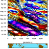
tmagan Posted August 23, 2012 Share Posted August 23, 2012 00Z Observations Link to comment Share on other sites More sharing options...
Thundersnow12 Posted August 23, 2012 Share Posted August 23, 2012 18z GFDL Link to comment Share on other sites More sharing options...
David Reimer Posted August 23, 2012 Share Posted August 23, 2012 Link to comment Share on other sites More sharing options...
packbacker Posted August 23, 2012 Share Posted August 23, 2012 Neat little history chart of past storms within proximity to Isaac, courtesy of our local news. Pretty amazing how few hit Florida. Link to comment Share on other sites More sharing options...
andyhb Posted August 23, 2012 Share Posted August 23, 2012 Impressive western trend there...compared to 24/48 hrs ago. Link to comment Share on other sites More sharing options...
Superstorm93 Posted August 23, 2012 Share Posted August 23, 2012 00z TVCN is due south of Panama City by D5. Models seems to have adjusted due to the new center location. I hate speculating on the NHC's track, but I would think that an adjustment to the south and west is likely. EDIT: That TVCA track would be close to the "worst case scenario" Starting to feel better now that we have -85C tops over the LLC Link to comment Share on other sites More sharing options...
andyhb Posted August 23, 2012 Share Posted August 23, 2012 18z GFDL Isn't that the 6z? Or am I missing something? Link to comment Share on other sites More sharing options...
nycsnow Posted August 23, 2012 Share Posted August 23, 2012 Isn't that the 6z? Or am I missing something? Ryan maue just posted same link on twitter, is the gfdl a good model? Sorry if it's a stupid ? Link to comment Share on other sites More sharing options...
wxsmwhrms Posted August 23, 2012 Share Posted August 23, 2012 Impressive western trend there...compared to 24/48 hrs ago. Just to show how some of the models have had a right trend on this storm, the 12Z UKMET from Tuesday indicated that Isaac should be moving over PR tomorrow evening. Link to comment Share on other sites More sharing options...
sctvman Posted August 23, 2012 Share Posted August 23, 2012 The 18Z would be a huge storm for FL north of West Palm and probably head toward GA or the Carolinas. Just one of the many solutions we have. Link to comment Share on other sites More sharing options...
Scott747 Posted August 23, 2012 Share Posted August 23, 2012 N42 in Isaac: The circulation does not extend over a deep layer. There is strong easterly flow at 4-5 km altitude. Link to comment Share on other sites More sharing options...

Recommended Posts
Archived
This topic is now archived and is closed to further replies.