andyhb
-
Posts
20,231 -
Joined
-
Last visited
Content Type
Profiles
Blogs
Forums
American Weather
Media Demo
Store
Gallery
Everything posted by andyhb
-
Why are we trying to spin this as a good thing? Seriously. There is no good reason to end SSMIS regardless of what program it is a part of. The other microwave imagery is a significantly degraded compared to SSMIS.
-
So monitoring/predicting rapid intensification is worth nothing? Yeah, no. Intensity forecasting is the more difficult aspect of TC forecasting compared to track.
-
F*ck this administration. Too political for the weather board? Too bad. Absolute nonsense to decommission microwave satellite data at any time, but especially immediately before hurricane season.
-
Wednesday could be pretty gnarly in the region especially if the 18z Euro or 00z NAM 3 km are on the right track.
-
That cell might be rather photogenic if you can get a view of it.
- 1,228 replies
-
- 1
-

-
- severe
- thunderstorms
- (and 2 more)
-
Pretty curious to see how today plays out in this region. Very potent vort max should provide a lot of dynamic support for strong convection, although the mid level lapse rates/instability definitely leave something to be desired (which immediately makes me question the height of the ceiling). Seems a supercell storm mode may be favored though, which given the magnitude of the low level shear should be a cause for some concern.
- 1,228 replies
-
- 11
-
-

-
- severe
- thunderstorms
- (and 2 more)
-
 At least 23 fatalities from that devastating E KY tornado last night, now the deadliest single tornado since Mayfield in the US. The damage near London is catastrophic.
 -
Fatalities confirmed in London KY from the long-tracked destructive tornado that went through Somerset (Pulaski Co.) and London (Laurel Co.) earlier.
-
Somerset KY tornado.
-
2 fatalities in Scott Co. MO from earlier tornado. Large tornado down W of Somerset KY rn. This has indeed turned into a very significant/widespread event.
-
Tornado down, power flashes. This is bad.
-
St. Louis might be in trouble here. Rapidly organizing low level circulation moving right towards downtown.
-
Veered surface winds are the only thing that is having me question the exact ceiling re: tornado threat with this one. Otherwise, pretty much everything is primed.
-
Lansing getting hammered by the strongest part of that line right now.
-
Tornado just made a direct hit on Mayville WI, pop. >5000.
-
Tornado in progress near Juneau WI right now.
-
Those are some impressive obs across N/central IL right now. Lots of upper 80s temps/low 70s dewpoints with backed surface winds. Should moisture stay near that level, this could really change the game (in a bad way) for the Chicago area later.
-
00z HRRR gets way too warm down south, outflowy/hail-driven mess if that's the case. Still has a few supercells in Wisconsin. Edit: And shows what would likely be a major severe weather outbreak on Friday across the OV/Mid South.
-
The MPAS variants like this idea too. Given the environment, that cell would be a whopper and probably significantly tornadic.
-
Most of the high res guidance has this now.
-
Friday (5/16) should be added to this thread. Think it has more potential to become a widespread severe episode than Thursday, which may be a bit more localized pending moisture quality.
-
Friday could also be a problem for areas further south into the Ohio and Tennessee Valleys. Shortwaves with zonal flow down there can be quite prolific.
-
Synoptics here are pretty favorable for a significant event including almost all of the sub-forum. Big EML with steep lapse rates, plenty of moisture, a trough that looks to swing negative tilt at a pretty ideal time of the day, and the LLJ responding to that. Will need to watch out how much areas further south mix out especially since convection should probably hold off until later in the day. Could definitely see the Madison/MKE and Chicago areas get in on this, and perhaps N IN/S MI later on. The pre-frontal wind shift is very obvious on most guidance.
-
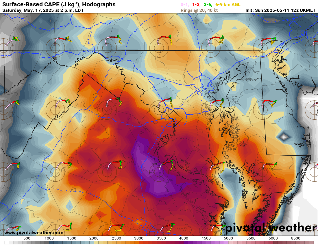
The 12z UK is a must check for shits and giggles for this region.

- 1,228 replies
-
- 5
-

-
-
- severe
- thunderstorms
- (and 2 more)
-
This is going to be a major event for the region.