andyhb
-
Posts
20,454 -
Joined
-
Last visited
Content Type
Profiles
Blogs
Forums
American Weather
Media Demo
Store
Gallery
Everything posted by andyhb
-

"Don’t do it" 2026 Blizzard obs, updates and pictures.
andyhb replied to Ginx snewx's topic in New England
Those Fall River pics remind me of some that I’ve seen out of Woonsocket/vicinity from 1978. -
"Don’t do it" 2026 Blizzard obs, updates and pictures.
andyhb replied to Ginx snewx's topic in New England
Next level/biblical stuff out of Fall River MA. -
"Don’t do it" 2026 Blizzard obs, updates and pictures.
andyhb replied to Ginx snewx's topic in New England
Yeah it was 34.5", that's the highest I can think of for second place. -
"Don’t do it" 2026 Blizzard obs, updates and pictures.
andyhb replied to Ginx snewx's topic in New England
There's like two dozen 30"+ reports from the Providence area, you were just north of the highest amounts. -
"Don’t do it" 2026 Blizzard obs, updates and pictures.
andyhb replied to Ginx snewx's topic in New England
I may be wrong, but for the official stations of the major cities (BDL, PVD, BOS, ORH, etc), is that the highest storm total ever recorded in SNE? -
"Don’t do it" 2026 Blizzard obs, updates and pictures.
andyhb replied to Ginx snewx's topic in New England
https://mesonet.agron.iastate.edu/wx/afos/p.php?pil=RERPVD&e=202602240000 37.9 inches at PVD!! -
"Don’t do it" 2026 Blizzard obs, updates and pictures.
andyhb replied to Ginx snewx's topic in New England
Just unreal. No idea what the total is now, but I wouldn’t rule out 40.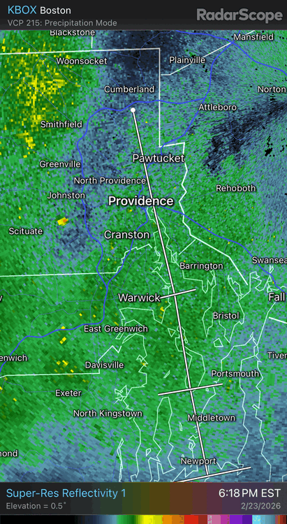
-
"Don’t do it" 2026 Blizzard obs, updates and pictures.
andyhb replied to Ginx snewx's topic in New England
Boston getting the goods now with that re-developing band, and PVD too, which is hilarious. -
"Don’t do it" 2026 Blizzard obs, updates and pictures.
andyhb replied to Ginx snewx's topic in New England
Radar is filling back up over RI/E MA with the approach of the deformation axis on the backside. Probably going to make a run at 40" in spots. -
"Don’t do it" 2026 Blizzard obs, updates and pictures.
andyhb replied to Ginx snewx's topic in New England
40" within reach? -
"Don’t do it" 2026 Blizzard obs, updates and pictures.
andyhb replied to Ginx snewx's topic in New England
Official NWS observation at the airport. -
"Don’t do it" 2026 Blizzard obs, updates and pictures.
andyhb replied to Ginx snewx's topic in New England
And now a 33.5" report from 2 E Providence. Clearly an all time storm for the city along with Feb 1978. -
"Don’t do it" 2026 Blizzard obs, updates and pictures.
andyhb replied to Ginx snewx's topic in New England
A 3 footer at an official obs site for a major city would be insane, and I think that's becoming pretty likely. -
Providence RI is breaking a long standing record from 1978 as we speak. Incredible obs coming out of there.
-
"Don’t do it" 2026 Blizzard obs, updates and pictures.
andyhb replied to Ginx snewx's topic in New England
Latest observation is just insane for an official site as well. -
"Don’t do it" 2026 Blizzard obs, updates and pictures.
andyhb replied to Ginx snewx's topic in New England
That's a legendary record falling as we speak. -
"Don’t do it" 2026 Blizzard obs, updates and pictures.
andyhb replied to Ginx snewx's topic in New England
I have strong suspicion that they might as this point, they've been sitting under that band for at least a couple hours since the last observation plus it seems there is a bit of a westward expansion/extension right around PVD's latitude. Then you have all of the backside deformation/etc. to go as the storm continues lifting NE. -
"Don’t do it" 2026 Blizzard obs, updates and pictures.
andyhb replied to Ginx snewx's topic in New England
Where are you getting these reports? Need some corroborating evidence. -
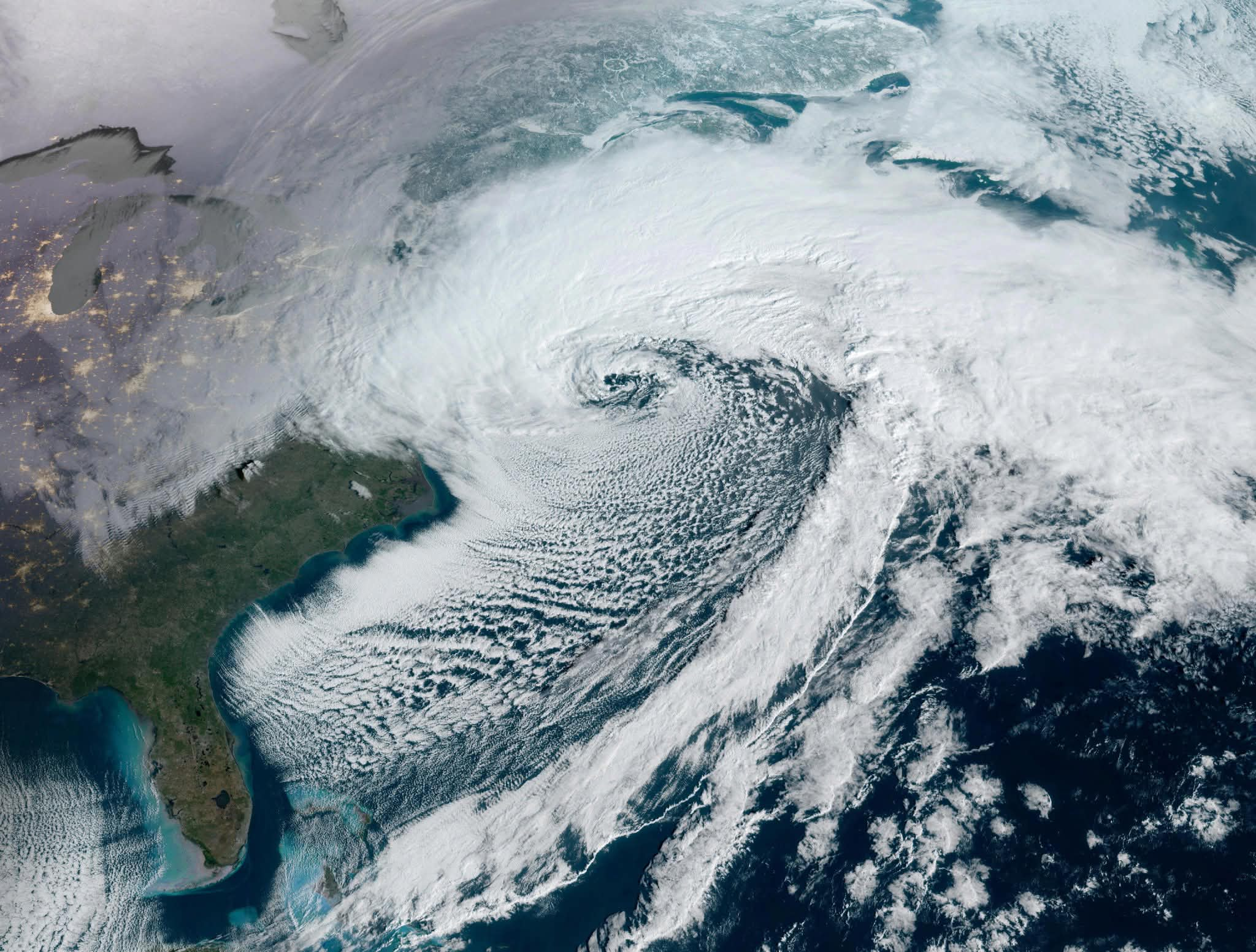
All-timer satellite image.

-
"Don’t do it" 2026 Blizzard obs, updates and pictures.
andyhb replied to Ginx snewx's topic in New England
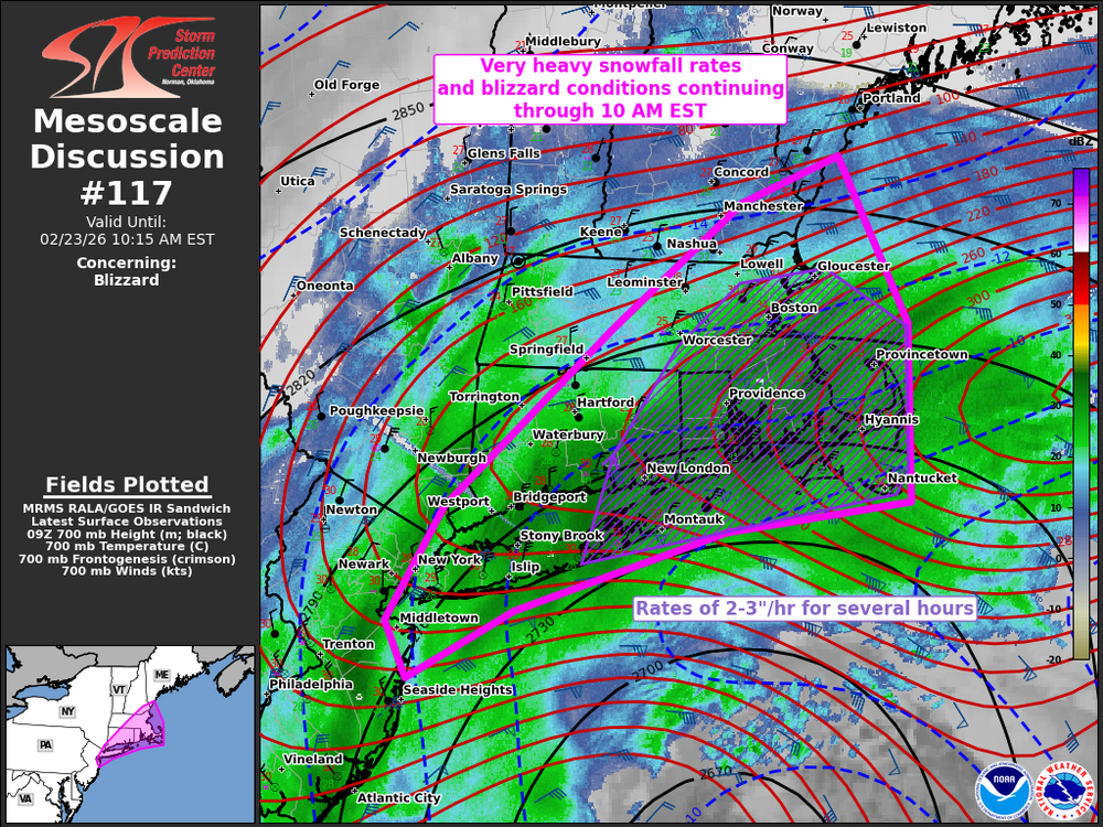
That's an MCD for the ages right there. -
One of the greatest MCDs you will ever see for a snowstorm right here from SPC.
-
"Don’t do it" 2026 Blizzard obs, updates and pictures.
andyhb replied to Ginx snewx's topic in New England
Can you even call that a "band"? It's more like a shield of whiteout conditions. -
"Don’t do it" 2026 Blizzard obs, updates and pictures.
andyhb replied to Ginx snewx's topic in New England
Providence is about to get absolutely crushed.