andyhb
-
Posts
20,454 -
Joined
-
Last visited
Content Type
Profiles
Blogs
Forums
American Weather
Media Demo
Store
Gallery
Everything posted by andyhb
-
Large tornado in progress just east of KVWX heading for Fort Branch IN.
-
72 dBZ debris ball south of Indy, that is a mean tornado.
-
That was a different (I believe 4 hour) product than the 24-hour aggregate being shared widely.
-
Main uncertainty being the placement of the warm front and antecedent convection.
-
Have to imagine a D2 MDT is coming given the magnitude of the setup being shown by the 00z guidance thus far, with some supercells on the CAMs interacting with it. Just incredible wind fields.
-
Generally when you blend a record strength 500 mb shortwave with a record strength surface low, you're going to expect some pretty anomalous outcomes assuming moisture is available, which it looks to be.
.thumb.png.63de12ab5eb22478206e6197893d2b8c.png)
-
The 12z Euro… holy moly.
-
As of right now, this looks like an outbreak over potentially a large expanse of real estate, with both strong tornadoes and a derecho possible. I’m amazed at how strong the LLJ is across many models right now.
-
Agreed, it looks like another potentially widespread and significant severe weather episode with very strong flow overlapping high moisture. Tuesday could have some potential too.
-
This is hands down one of the best tornado videos I have ever seen. Hopefully a long format one is to follow.
-
Washburn IL, Streator IL, and Kouts IN tornadoes all preliminarily rated EF3.
-
Huge wedge tornado reported NE of Kouts per Isaac Polanski.
-
Tornado down heading for Schaumburg @SchaumburgStormer!
-
That is a major tornado in the middle of the Lake County burbs, that is not going to be good.
-
Giant tornado near Streator IL per Colin Davis. Environment near those two supercells in central IL is extreme, STP of 10, SCP of 40, 3000+ MLCAPE and 500+ ESRH.
-
Violent tornado in progress near Metamora IL, amazing low reflectivity debris ball.
-
Developing Edina MO cell looks like a candidate for a long-lived supercell. Got that kidney bean shape.
-
Via Clint Hendricks. Apparently became a large stovepipe and then a cone after this.
-
Very reliable report here.
-
Tornado in progress near Lucerne MO, TDS, report from Colin Davis.
-
Central/southern part of the Chicago metro is getting rocked. Seeing a lot of 80-90 mph outbound bins from KLOT not too far off the deck.
-
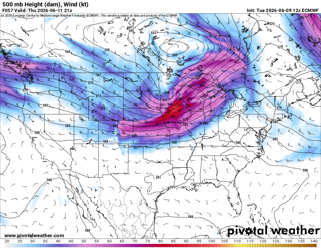
The 3 km NAM has a 100 kt 500 mb max tomorrow in IA, I cannot recall very many systems at all with that in June @RCNYILWX.
-
Parameter space near/south of that warm front in the backed surface winds tomorrow is alarming for any semi-discrete storms that can maintain themselves in the area. While there certainly are some caveats such as storm mode, degree of HP dominance given less than ideal venting flow and high PWATs, and prior convection, the high population and potential for relatively fast moving storms makes this likely the most dangerous setup so far this year on paper.
-
That is quite a potent shortwave on the 12z Euro for Thursday with a 90+ kt 500 mb max, especially for June. Morning convection will rule the roost as usual, but I would expect a pretty widespread and potentially significant severe event given the magnitude of the flow overlapping strong instability.

-

Potential Sever Weather Outbreak 4/27/2026
andyhb replied to pen_artist's topic in Lakes/Ohio Valley
PDS tornado watch out for the area surrounding the MS/OH River confluence. 80/80 tornado probabilities.


.png.981588a393ec053f28cdcd9c1833d79b.png)