andyhb
-
Posts
20,454 -
Joined
-
Last visited
Content Type
Profiles
Blogs
Forums
American Weather
Media Demo
Store
Gallery
Everything posted by andyhb
-
It's stalling right over Philly...
-
Dropping in to say that arcing FGEN band is absolutely exploding on radar over Philly, this might be perfect for the city proper if it stays there for several hours.
-
From what I've seen on the mesoanalysis page, the low itself has barely gained any longitude in the past 4+ hours. Got caught by the 500 mb trough and rapid height falls/swinging negatively tilted.
-
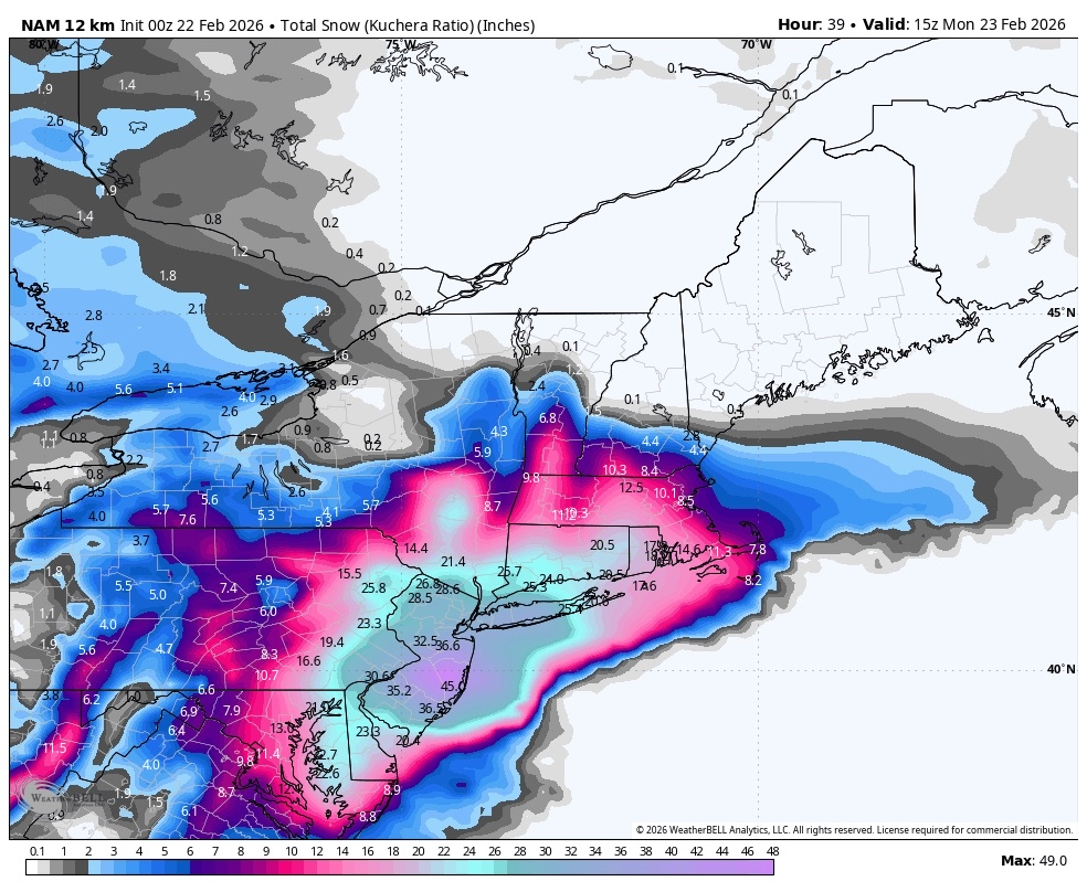
That band forming over the north shore of Long Island is some major league shit.
-
Well, this GFS run certainly ain't going to be one to back down. Incredible stuff into NYC.
-
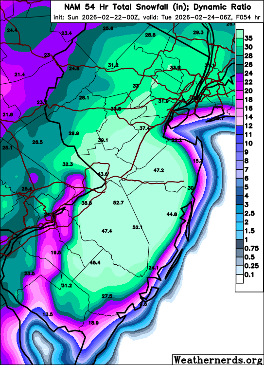
Dynamic ratio from wxnerds is even more absurd. Save these images people, you may never see this again (or maybe you will on the next NAM run).
-
Sorry, had to post it again since it actually cracks 50 inches in NJ. Outrageous.
-
About that...

-
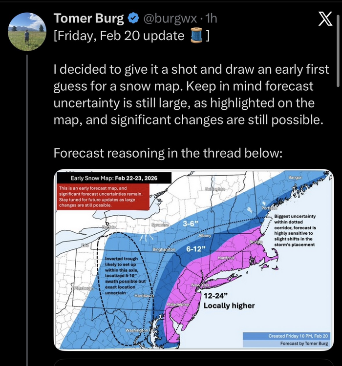
It would appear that Tomer is on board.
-
Basically the whole I-95 megalopolis gets smashed on that 00z GFS run, everyone wins.
-
Let's take a box average including ORH, PVD, and BOS at 66 hours...
-
Absolute crush job.
-
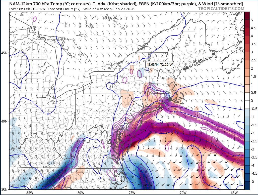
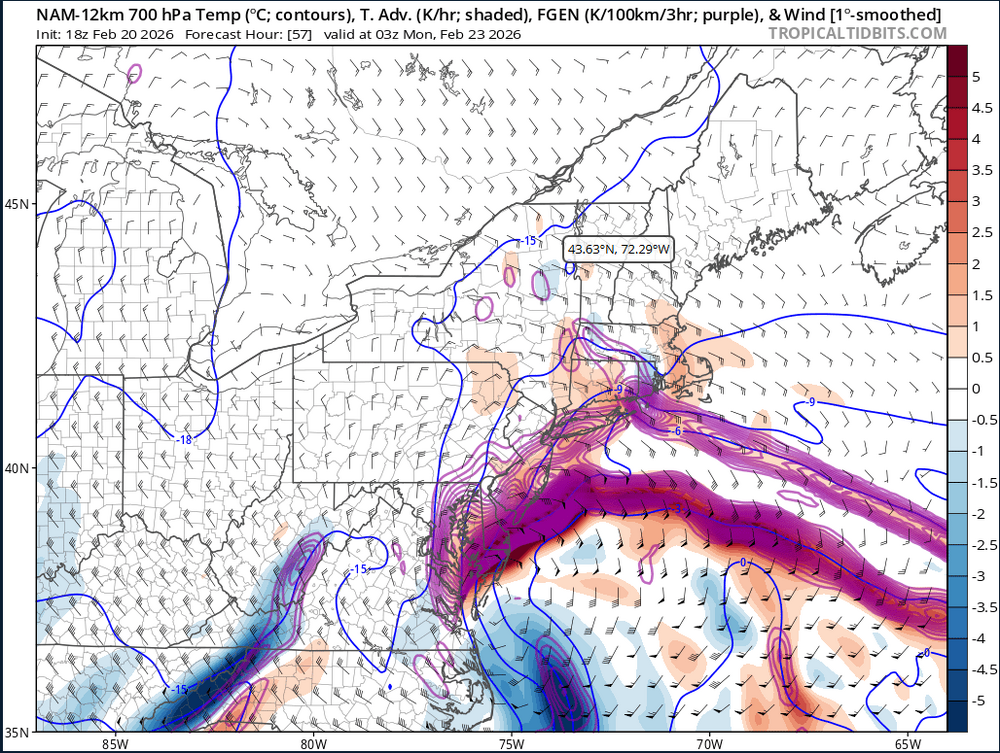
One of the craziest FGEN signals I’ve ever seen off that 18z NAM. Like wtaf.

-
This is one of the dumbest FGEN plots I’ve ever seen on the 18z NAM.
-

January 30th- Feb 1st ULL and coastal storm obs
andyhb replied to JoshM's topic in Southeastern States
MHX office just reported 15” snow depth. With all of the blowing/compaction/etc, that’s probably pushing 18” in total snowfall. -
January 30th- Feb 1st ULL and coastal storm obs
andyhb replied to JoshM's topic in Southeastern States
Those totals seem a bit low to me given New Bern was in the double digits last night. Have these been updated? There’s 15-20” reports coming from the areas near and south of Jacksonville. -
January 30th- Feb 1st ULL and coastal storm obs
andyhb replied to JoshM's topic in Southeastern States
Whopper of a deformation band setting up from Jacksonville to Greenville in E NC right now as the low rapidly deepens with the trough going negatively tilt. Have to think 20"+ or perhaps even two feet is on the table for some. -
January 30th- Feb 1st ULL and coastal storm obs
andyhb replied to JoshM's topic in Southeastern States
This is going to be the 21st Century winter storm of record for many in the Carolinas ultimately, especially with blizzard conditions occurring at the coasts. -
January 30th- Feb 1st ULL and coastal storm obs
andyhb replied to JoshM's topic in Southeastern States
This map is going to look a lot more impressive when it is all said and done. Will be historic for the NC coastal regions as well. -
As an onlooker from outside the area perusing, I think I’m losing my mind reading your posts. Any storm that gives ORH and BOS 22”+ is going to be remembered by many.
-
1/24-1/25 Major Winter Storm - S. IL, IN, and OH
andyhb replied to A-L-E-K's topic in Lakes/Ohio Valley
Queens Park just reported 5.5” in the last hour, unbelievable. -
1/24-1/25 Major Winter Storm - S. IL, IN, and OH
andyhb replied to A-L-E-K's topic in Lakes/Ohio Valley
Im glad they’re also measuring at Queens Park because YYZ’s iffy measurements are notorious. -
1/24-1/25 Major Winter Storm - S. IL, IN, and OH
andyhb replied to A-L-E-K's topic in Lakes/Ohio Valley
What is happening in Toronto/vicinity right now is incredible. 3-4”/hr rates for hours as a heavy LES band is parked across the metro due to easterly flow from the main synoptic storm. Could break the all time record there in fairly short order. -
Hundreds of miles of rippage.
-
1/24-1/25 Major Winter Storm - S. IL, IN, and OH
andyhb replied to A-L-E-K's topic in Lakes/Ohio Valley
That band from S IL through S IN into SW OH between Cincinnati and Dayton is a monster, spreading NE towards Columbus too.