Search the Community
Showing results for 'josh'.
-
our boy josh for sure
-
Josh and I once experienced a tor warned cell from the concourse during a cubs tigers game
-
A few of us knew you from day 1 and it’s been over 20 years now and you are famous so drop in and say Hi to us little people!! HMP
-
Not sure anyone saw this but Josh Timlin put together a great page which aggregates all kinds of cool weather maps and data: https://contextclimate.io/#/
-
I use MRCC cli-MATE data portal. Josh may use something else. https://mrcc.purdue.edu/
-

1/24-1/25 Major Winter Storm - S. IL, IN, and OH
Stevo6899 replied to A-L-E-K's topic in Lakes/Ohio Valley
I've experienced several as my job used to require me to travel. You think I'd be wasting my time arguing with the wall (josh) if all I wanted was to experience one in general? I want so much snow here it knocks out power in wyandotte and I can go a few days without Josh's turd polishing glass half full climo bs. -
It is 'funny' how Josh Allen mistakes are downplayed while Lamar's are magnified. Imagine if Lamar turned the ball over 4 times in a playoff game then cried afterward. The hate would be off the charts. Good player, but the Josh Allen love by the media is nauseating.
-
Thanks Josh. Damn! Still big ice totals. Im getting plastered in Alpena right now as it is. I got food,gas,propane and my two snowmobiles ready to go.
-
Thanks. OMG! Im in Alpena Michigan with 1.02" ! We just got 0.40" of ice yesterday that hasn't melted off trees.Tomorrow 6" then the big one. We suffered greatly during last March's ice storm like Josh.
-

The “I bring the mojo” Jan 30-Feb 1 potential winter storm
ncforecaster89 replied to lilj4425's topic in Southeastern States
It’s a direct consequence of the more eastward track and finding ourselves in the strong subsidence zone, while the more inland areas are in the deformation zone. There’s always going to be winners and losers in these type of setups…with a coastal low that’s bombing. In this particular run/solution, we are the undisputed losers. But like Josh noted, it’s still too early to pinpoint the precise location of these dynamics.
-
Im glad we can entertain y'all. With there being so many of us, that seems normal that everyday there's something to learn about Michigan weather history. It is a weather board. Blame Josh with all his stats n shit.
-
1/24-1/25 Major Winter Storm - S. IL, IN, and OH
Stevo6899 replied to A-L-E-K's topic in Lakes/Ohio Valley
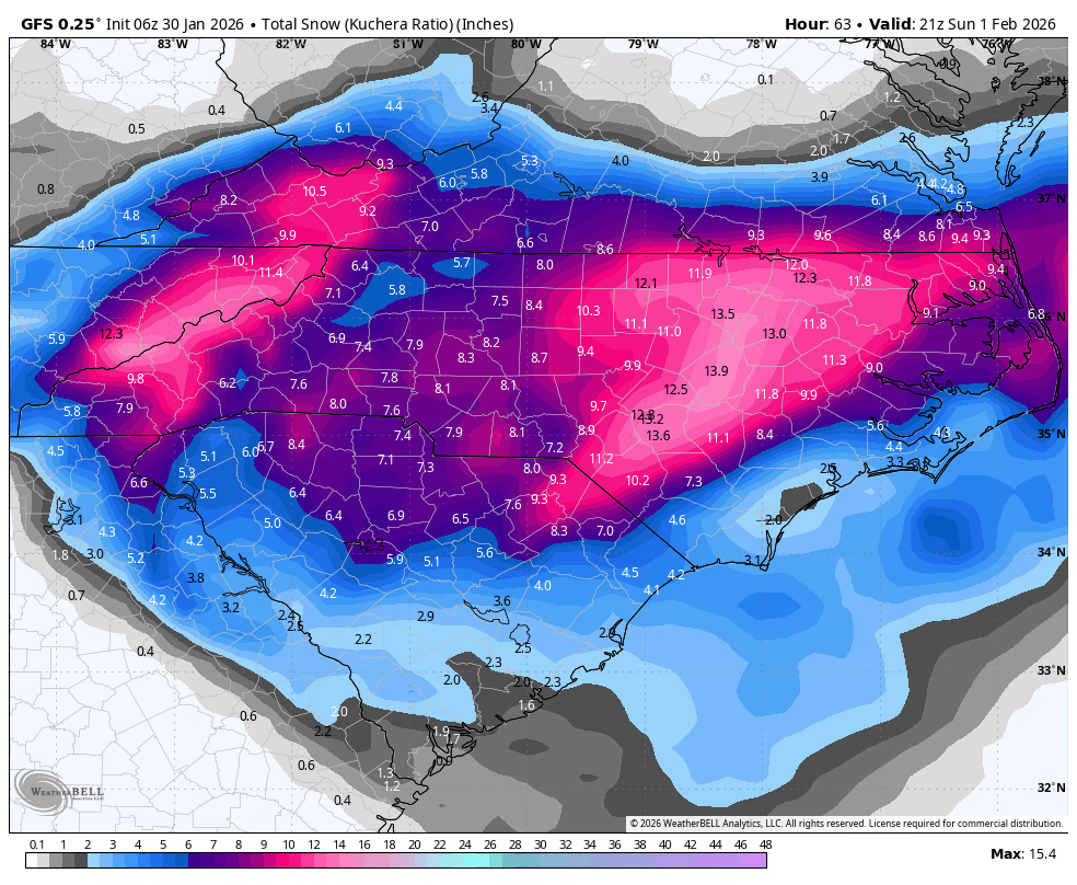
Ahh so you're the big dog repellent. Kidding. Im sorry you had to move. Not a better place to be in the summer though. Me and Josh go back and forth about this every winter. He likes the nickel diming shit and snowcover. Im okay with 3 snowless winters in a row a decade if it means a big dog every other yr for a good stretch. Boston has had atleast 10 20+ storms since 2000. Detroits had 100+ 1-3 events. I know its not in our climo to get big dogs but when you see everyone else getting one, it's annoying lol. Also I see our friends in ohio/Indiana did well but not nearly close to some of the kuchera maps we were seeing that I thought would verify with the arctic air in place. Perhaps too much dry air or ratios weren't as good as we thought due to it being too cold. -
Now it’s serious. A triple dog dare. Josh committed a slight breach in etiquette by skipping the double dog dare and going straight for the throat.
-
1/24-1/25 Major Winter Storm - S. IL, IN, and OH
Stevo6899 replied to A-L-E-K's topic in Lakes/Ohio Valley
This is one of those where josh could get 8 inches, while my backyard gets a dusting. You should do well. -
Winter 2025-26 Short Range Discussion
Stevo6899 replied to SchaumburgStormer's topic in Lakes/Ohio Valley
Well when winters suck and are boring like they have been for years, there's nothing else to do on here than quibble back n forth with josh for fun. -
Winter 2025-26 Short Range Discussion
Stevo6899 replied to SchaumburgStormer's topic in Lakes/Ohio Valley
That's me that says that, not josh. Dont poke the bear or he will stat you 6 feet into the ground. -

Winter 2025-26 Medium/Long Range Discussion
buckeye replied to michsnowfreak's topic in Lakes/Ohio Valley
if the trend on that 18z euro continues with more and more of a big phase....Josh might be reeling this one in. -
https://www.icyclone.com/s/iCyclone_Chase_Report_MELISSA2025.pdf Main points: My location on the SW coast of Jamaica was well inside the RMW (radius of maximum winds) and got the eyewall’s inner right-front quadrant. The SE edge of the eye apparently grazed my location, temporarily bringing reduced wind speeds, improved visibility, and a marked shift in wind direction. My minimum pressure was 926.0 mb. While this might seem high, the report discusses how it actually makes sense, given recon data and the fact that I was probably a few miles from the absolute center. MELISSA's winds were absolutely ferocious—the most intense I've witnessed in 84 hurricanes. And the resultant wind damage was spectacular. This was a truly rare specimen. This is a preliminary version of this report which I rushed to completion because of time-sensitive requests for the data. In the next couple of weeks, I'll be releasing an expanded version with plentiful damage pics. Josh Morgerman iCyclone
- 3 replies
-
- 11
-

-

-

Pittsburgh/Western PA WINTER ‘25/‘26
colonel717 replied to Burghblizz's topic in Upstate New York/Pennsylvania
At least the WTOD is being depicted more south than GFS. Still 6-7 days to sort this out. Models have all been terrible even short range as you see on Josh's sight yesterday and today. -

Central PA Winter 25/26 Discussion and Obs
Itstrainingtime replied to MAG5035's topic in Upstate New York/Pennsylvania
I finished with .51" of rain. It was a rough weekend. In full disclosure - I've been a fan of Jacksonville since they entered the league in 1995. Growing up I was a diehard Colts fan. When they left Baltimore after the 1983 season (I was 19) and moved to Indy, I despised them. I started following the Eagles and Steelers but never really gave my heart to them like i had with the Colts. So when Jacksonville got an expansion team, I started to root for them. I still to this day root for Pitt and Philly but my true NFL allegiance is in NE Florida. I've traveled to watch them play and have also seen 2 games in Jacksonville. Needless to say, my heart was shredded every bit as much yesterday as yours was the night before. Only difference is that Jax has never won anything, which made yesterday hurt even more. Good news I guess is, while I'm not a Bills fan per se, I love Josh Allen. He is my favorite player in the NFL. I'm hoping the Bills go on a run and finally exercise their demons. -
NFL is 3 for 3 with amazing wild card games this weekend. Josh Allen is an absolute beast.
-
our boy josh really is the ultimate head for our subforum, absolutely savors every bit of snow he is given
-
True, i just don’t want to face Josh Allen with our pathetic pass rush.
-
Hurricane Josh's Melissa chase is up. Insanely intense. Up there was the Marsh Harbor footage in Dorian.