All Activity
- Past hour
-

July 2025 Discussion-OBS - seasonable summer variability
Big Jims Videos replied to wdrag's topic in New York City Metro
The ocean temp at Point Pleasant Beach yesterday afternoon was close to 80 degrees. Went for a swim after work. Warmest I've ever felt this time of year. Great flip from the endless upwellings we experienced last summer. Also a bunch of cow nose rays scared folks out of the water before I got there as folks thought they were sharks. -

July 2025 Obs/Disco ... possible historic month for heat
jbenedet replied to Typhoon Tip's topic in New England
68.2 SST for UNH buoy. That is toasty for the date. Wow. -
Serious flooding NE of Greensboro right now I’d imagine
-
 An analysis below of our declining number of 90 degree days over the past 7.5 decades here in Chester County. I have split the stations by elevation. Those over 500 ft vs those at lower elevations.
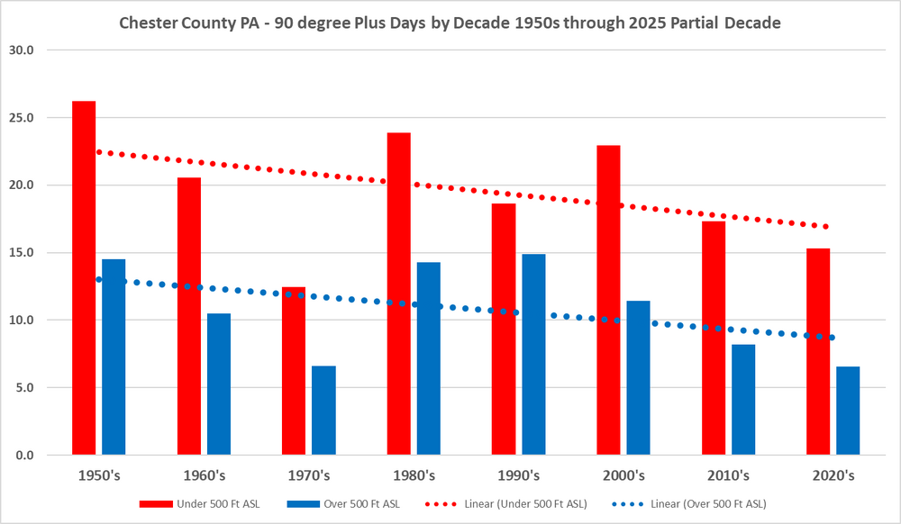
-
An analysis below of our declining number of 90 degree days over the past 7.5 decades here in Chester County. I have split the stations by elevation. Those over 500 ft vs those at lower elevations.
-

2025-2026 ENSO
Stormchaserchuck1 replied to 40/70 Benchmark's topic in Weather Forecasting and Discussion
With the PDO so negative, I think we can increase the chances for warmer CONUS Fall, at least Sept-Oct, and especially October - the pattern of the 2000s. This hit big time last year, with a counter-intuitive -0.5 correlation H5 +EPO in Sept-Oct. It may be a warm Pacific pattern in October. -

July 2025 Obs/Disco ... possible historic month for heat
512high replied to Typhoon Tip's topic in New England
Maybe later in the day they dropped, around 1030-11 I checked check was at 90F with a dew of 72. regardless, swamp ass, walked in the house shirt soaked, could not get it over my back, walked into the door frame lol. Current Davis at home 90 from 92 high/ dew 69 -
It's still so swampy out. Mosquitoes are growing exponentially. Good luck outdoor events the rest of the year. Haha, can't wait to see West Nile ticker this August. Sent from my SM-G970U1 using Tapatalk
-
On my ski trip, we did Aosta Valley, Chamonix and Zermatt. Fell in love with Aosta Valley. Beautiful valley with middle age ruins and vineyards. Friends are mountain biking there next month. I've been thinking of going back at some point and renting an apartment for a few months. By car, you can hit 15 or so ski areas within 90 minutes or less.
-

July 2025 Discussion-OBS - seasonable summer variability
LoboLeader1 replied to wdrag's topic in New York City Metro
Topped out @ 88 today. DP & RH didn't help. Dew Point 72 F Humidity 65 % -
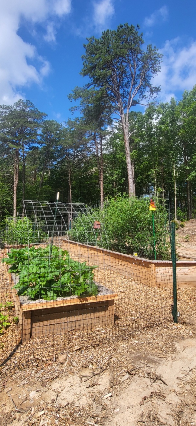
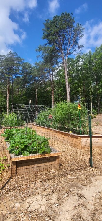
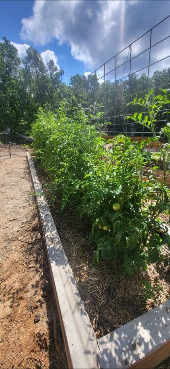
Grabbed a couple garden pics this AM. Veggies consist of squash and zukes in the closest bed with the trellis and the other trellis bed in the distance is beans like scarlet runners and some cukes. Empty bed kinda hidden is potatoes in grow bags. We just harvested most of them and replanted. Smallish yields but bags are really easy to deal with when growing potatoes. Big long bed is killing it. It's actually 2 rows of plants with a string of peppers in front (jalapeno, Tabasco, shishito, nardello, poblano, Italian cherry) and a WALL of tomatoes behindlol. All kinds of tomatoes that I can't remember most of. Coyotes are my faves. I just eat them whenever lol. The rest are various heirlooms and nearly every plant is stacking up with fruits. We've had some pest problems but pretty minor so far. We had shit luck with tomatoes in Rockville. Always something like fungus, mildew, and blossom end rot. Down here is much more forgiving. Pretty sure it's cooler nights and low pollution. It's rare to have lows above 70 in the forest. Still gets hot AF during the day but the natural air conditioning of the forest is pretty amazing. Next year we'll have a 12'x24' greenhouse built along with at least triple the amount of beds. This year is experimental and it's far exceeded our expectations already. Incredibly satisfying
-

July 2025 Discussion-OBS - seasonable summer variability
donsutherland1 replied to wdrag's topic in New York City Metro
Following yesterday's deluge, today was a much drier day. Some showers or thundershowers could return to the region tomorrow afternoon and tomorrow night. It will turn somewhat warmer tomorrow with temperatures rising through into the middle and upper 80s. The heat will likely peak on Thursday with highs topping out in the upper 80s and perhaps lower 90s. A warm and mainly dry weekend will follow. No widespread and sustained excessive or record-challenging heat appears likely through the first three weeks of July. The ENSO Region 1+2 anomaly was +0.4°C and the Region 3.4 anomaly was 0.1°C for the week centered around July 9. For the past six weeks, the ENSO Region 1+2 anomaly has averaged +0.52°C and the ENSO Region 3.4 anomaly has averaged +0.07°C. Neutral ENSO conditions will likely continue through the summer. The SOI was +2.09 today. The preliminary Arctic Oscillation (AO) was +0.295 today. Based on sensitivity analysis applied to the latest guidance, there is an implied 71% probability that New York City will have a warmer than normal July (1991-2020 normal). July will likely finish with a mean temperature near 79.0° (1.5° above normal). -

July 2025 Obs/Disco ... possible historic month for heat
kdxken replied to Typhoon Tip's topic in New England
Looks like the highs were 86/64 Worcester and 86/72 Boston. Definitely lower inland. -
July 2025 Obs/Disco ... possible historic month for heat
kdxken replied to Typhoon Tip's topic in New England
88/67 was the high today at Sterling National. Little warm for my liking but who's to complain.
-

July 2025 Obs/Disco ... possible historic month for heat
Baroclinic Zone replied to Typhoon Tip's topic in New England
Hey another 90+ day in the 2025 book. 93F Thats 5 days this month now. Add that to 11 days in June. -

93L – “Inactive” Season Posting Check-In
Kevin Reilly replied to BarryStantonGBP's topic in Tropical Headquarters
If 93L comes off and can manage a further SW track before turning west then west-northwest then northwest it would stand a much better chance at development over water for a longer period of time. -

July 2025 Discussion-OBS - seasonable summer variability
nycwinter replied to wdrag's topic in New York City Metro
SnoSKi14 don't see that -

2025 Short Range Severe Weather Discussion
frostfern replied to Chicago Storm's topic in Lakes/Ohio Valley
Popups east of 131. WI complex shits the bed over the lake. More popups east of 131. Then it’s all whiffing south along I-80. Maybe I-94 gets some stratiform scraps. I-96 west of 131 desert. -

July 2025 Discussion-OBS - seasonable summer variability
uofmiami replied to wdrag's topic in New York City Metro
Looks to be a brief break of one day only, but it'll be welcomed for sure. -

July 2025 Obs/Disco ... possible historic month for heat
Torch Tiger replied to Typhoon Tip's topic in New England
Hopefully beyond my lifetime, but near-future, SSTs exceed mid-80's to even 90F for those Buzzards Bay type inlets, and so on! And SW, LI sound etc. -

July 2025 Obs/Disco ... possible historic month for heat
Dan76 replied to Typhoon Tip's topic in New England
Alex kintner disagrees. -

July 2025 Discussion-OBS - seasonable summer variability
Brian5671 replied to wdrag's topic in New York City Metro
Wow nice....that's a welcome change for a couple of days. -
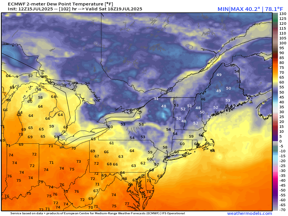
The localized drought feedback is real here. Only spot where dewpoints have mixed down into the mid 50s despite a SSW wind.
-

93L – “Inactive” Season Posting Check-In
WxWatcher007 replied to BarryStantonGBP's topic in Tropical Headquarters
Yeah like the other models it has its moments. 93L has a pretty impressive look on IR and radar. Definitely aided by daytime heating but given its location I think this has a solid chance of development. Maybe 60%. - Today
-
July 2025 Discussion-OBS - seasonable summer variability
uofmiami replied to wdrag's topic in New York City Metro
.png.fee4d64d6e8c4ed9d1b82d9699f6c458.png)