All Activity
- Past hour
-
High of 66 yesterday with 0.76” of rain. Warming trend begins today.
-
EPS is showing a strong EWB in ENSO region 3.4 to start July. That should induce upwelling and renewed cooling
-

July 2025 Obs/Disco ... possible historic month for heat
CoastalWx replied to Typhoon Tip's topic in New England
I agree….i see it too. I guess it didn’t quite get my attn yet. It’s been a good forecast to always hedge warmer….hell not just in summer too, but I won’t go there. Solid summer weather on the way for the foreseeable future. -
The lowlands of AA County have been swamped this week. I had a classic, strobe light, nighttime thunderstorm last evening that dropped 1.90". I've had over 3" this week. No drought here. We're in the green now.
-
Timing blows a bit tomorrow but western areas could see some storms during the early evening. Probably see marginal expanded east some with an upgrade to a slight risk in there
-
RIP Nam Discontinued
-
We need less buildings like upstate NY.
-
RIP Nam Discontinued
-

June 2025 discussion-obs: Summerlike
LongBeachSurfFreak replied to wdrag's topic in New York City Metro
So we should abandon cities and destroy rural areas and turn them into endless suburbs. The reality from the perspective of the planet is the EXACT OPPOSITE. We want more people in tightly packed cities and less McMansions on quarter acre lots. Upstate NY reforesting over the last century is a great example of what we want to see. -
0z Euro OP seemed to cool a little for Sunday in this area.
-
Yup . I could sense it about 10 days ago. You could see it starting on modeling
-
Let’s talk tomorrow!
-
64 lovely degrees this morning which ironically I believe is a touch above normal. Regardless, it feels SO much better outside! .35" of rain yesterday and one large tree lost during the storm. Cleanup commences today.
-

July 2025 Obs/Disco ... possible historic month for heat
Typhoon Tip replied to Typhoon Tip's topic in New England
As is ... sure. I just would remind folks 10 days to two weeks back the illustration of the runs were torpid at best, and at times absent of the eventual destiny of a bigger ridge anomaly/heat. However, looping - like watching them in cinema - conveyed a different suggestion. It's a situation where we could see another of these materialize, much in the same way ... coming out of an initial state where aspects are more vague. But, doing so heading into climo, + CC attribution, + the fact that as is, there is a + thickness anomaly due to WV loading ( probably related to former) and lows are going to be elevated. It's entirely possible to put up a top 10 or better July without even observing an official heat wave. ...etc. We're in a vulnerability for higher means... Maybe "possibly historic" is too strong for some people, fine - call it above normal. whatever You know ... any time and any place on Earth, since about 2002, whenever there's been mere suggestions hinting at the possibility of above normal temperatures, the return has been pretty dependable. -
I think my PWS is broken. It is showing it is 66 out. Really though while we missed out on the rain over here I am glad for this one day of gloom and lower temps before the oven cranks back on tomorrow. I have a feeling though looking into next week that I will be out watering the gardens.
-
WB 3K NAM aced the temps for today. Hopefully they can incorporate its temp forecast parameters into the other models before they retire it in 2026.
-
Iowa's decaying mass of precip dumped 0.06" here overnight. That brings us to 3.51" for June.
-
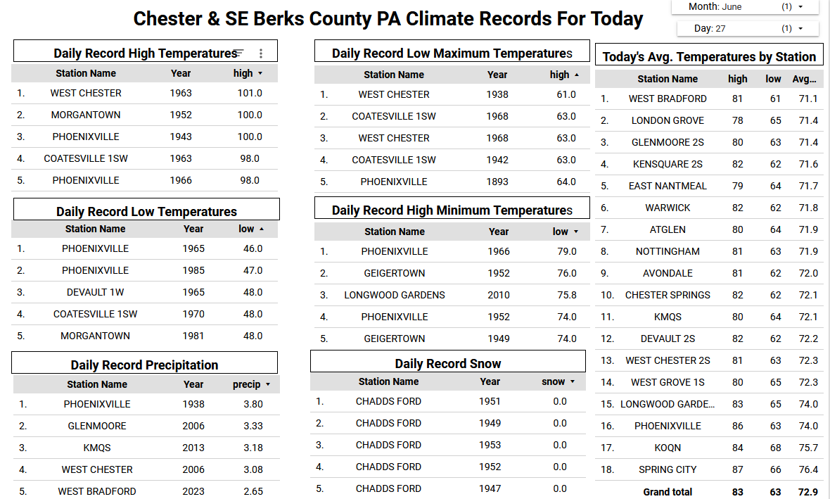
Rainfall amounts were pretty variable last night across Chester County. We saw as much as 2.35" at Nottingham and 2.17" at Atglen to as little as 0.17" at Devault. It’s much cooler today with temperatures in the low 70's. Across the higher spots of the County we may not see another 90-degree reading until the middle of July. Rain chances to ramp up a bit again tonight and again on Saturday night. We warm up to the upper 80's on Sunday before we see temperatures near normal in the mid 80's for much of the next week.

-
46.6°F for a low this morning............
-

E PA/NJ/DE Summer 2025 Obs/Discussion
ChescoWx replied to Hurricane Agnes's topic in Philadelphia Region
Rainfall amounts were pretty variable last night across Chester County. We saw as much as 2.35" at Nottingham and 2.17" at Atglen to as little as 0.17" at Devault. It’s much cooler today with temperatures in the low 70's. Across the higher spots of the County we may not see another 90-degree reading until the middle of July. Rain chances to ramp up a bit again tonight and again on Saturday night. We warm up to the upper 80's on Sunday before we see temperatures near normal in the mid 80's for much of the next week.
-
It's football season.. Training camp starts in a little over 2 weeks. Ravens first preseason game in 5 weeks.
-
This single cell storm put on a show last night:

-
Just keep that ensemble trough latitude shallow and we'll be fine.
-
94 was the high yesterday highest dp yesterday 81.3 heat index 112. rain yesterday .20