All Activity
- Past hour
-
Love it ! Yes!!
-

The return of the elusive Nor'easter. Drought buster or bust?
WxUSAF replied to dailylurker's topic in Mid Atlantic
About 0.25” for a 3 day total so far -
 Duration under gradient. Thankfully, neap tides. Its bad, but ive been here for many decades, my entire life. I still havd visual tide guages from 40 years ago. Id love to blame my areas back bay flooding on sea level rise, but thats not the case. There have been tremendous man-made changes to the inlet and surrounding areas that are almost certainly responsible. To each their own.
 -
It's been a F'n day.... will share pictures tomorrow of what really happened on Barnegat Bay. It was a good one....
-

E PA/NJ/DE Autumn 2025 Obs/Discussion
JTA66 replied to PhiEaglesfan712's topic in Philadelphia Region
Unrelenting drizzle, pushing 0.22”. 56F -
Looking forward to the return of sunshine. I think we snagged .05” here from 2 days of overcast. Next.
-
It was a medical flight. Reddit has a long thread on it .
-
I read the forecast and it doesn’t make much sense to me. December might be the warmest and driest month of the three in terms of anomalies and averages. JFM looks good at this point but of course at this range could turn to shit as we get closer. The below normal precip later in the winter could signal more snow than rain rather than less chances for precip overall. Even with the pattern looking favorable it’s hard to predict more than an average winter in terms of cold and snow which compared to the last few would still feel more wintry than previous seasons.
-
9 hours without power. Current Eversource ETA is 9pm to restore. Typical.
-

The return of the elusive Nor'easter. Drought buster or bust?
87storms replied to dailylurker's topic in Mid Atlantic
This storm is symbolic of the pattern the last few years. Is the Gulf of Mexico even capable of generating an impactful mid-Atlantic storm anymore? -
12 INCH SNOWSTORMS IN DC SINCE 1930 Year Event DCA or IAD ≥12”? 1942 Late March 1942 storm ✅ DCA ~14" 1958 Feb 15–16, 1958 ✅ DCA 14.4" 1966 Jan 29, 1966 ✅ DCA ~12" 1971 Dec 30, 1970 – Jan 1, 1971 ✅ DCA ~15" 1979 Feb 18–19, 1979 (Presidents’ Day) ✅ DCA 18.7" 1996 Jan 6–8, 1996 ✅ DCA 17" / IAD 24" 2003 Feb 16–18, 2003 ✅ DCA 16.4" / IAD 22" 2009 Dec 18–19, 2009 ✅ DCA 16.4" 2010 Feb 5–6, 2010 (“Snowmageddon”) ✅ DCA 17.8" / IAD 32" 2016 Jan 22–24, 2016 (“Jonas”) ✅ DCA 17.8" / IAD 29" 2026 (?) Jan 14–16, 2026 (?) ✅ DCA 22" / IAD 34" (?)
-
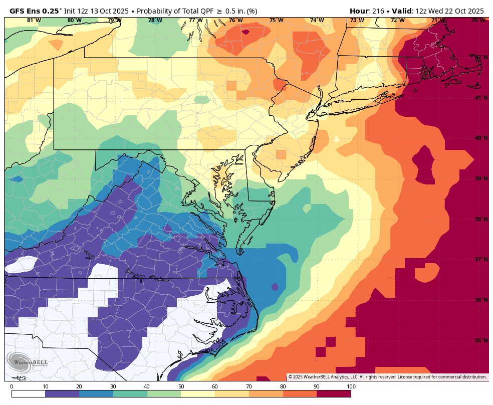
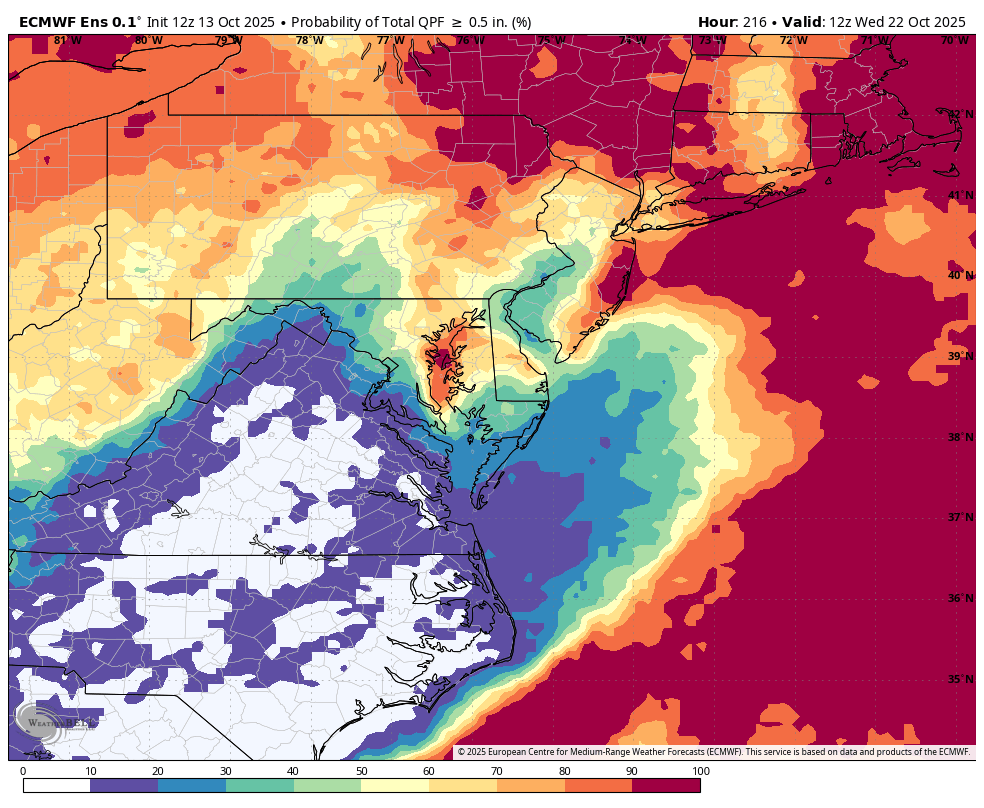
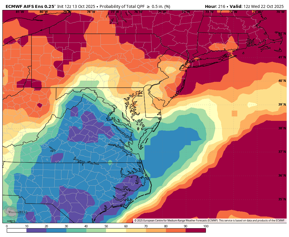
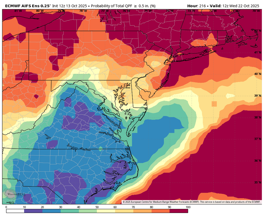
WB 12Z GEFS, EPS, and AI ensemble, next light/moderate rain chance late weekend; early next week.


-

E PA/NJ/DE Autumn 2025 Obs/Discussion
Birds~69 replied to PhiEaglesfan712's topic in Philadelphia Region
Seems to turn spotty once it passes Philly going from east to west...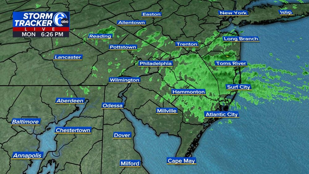
-

Spooky Season (October Disco Thread)
Damage In Tolland replied to Prismshine Productions's topic in New England
75-78 Sunday will be hot -
 1.73 inch of rain here from the storm. Still nasty with gusty winds and on and off rain.
 -
Yeah lets move that warm blob underneath the aleutians further east into GOA in the next couple of months, and we’re in business.
-
The nor'easter that brought heavy rainfall to the coastal plain is now poised to pull away. Some additional showers, periods of rain, and drizzle are likely overnight. Following the nor'easter, tomorrow will be mostly cloudy and mild. Clouds could break from west to east during the afternoon. Temperatures will top out in the lower 60s in many parts of the region. Wednesday will be partly sunny and milder with highs reaching the middle 60s. However, a fresh shot of cool air will move into the region late Wednesday or Wednesday night. Following the frontal passage, parts of the region could experience their coolest temperatures so far this fall. Dry conditions will likely prevail through the remainder of the week. In the 18 past years where Central Park saw at least two 80° or above highs and Newark saw at least two 84° or above highs during the first week of October, the temperature returned to 70° or above on at least one day during the second half of October in 17 (94.4%) of those cases. For all other cases, 84.1% saw at least one such high temperature during the second half of October. Therefore, the sharp cool spell very likely won't mean that New York City has seen its last 70° or above high temperature. The ENSO Region 1+2 anomaly was -0.1°C and the Region 3.4 anomaly was -0.3°C for the week centered around October 8. For the past six weeks, the ENSO Region 1+2 anomaly has averaged -0.12°C and the ENSO Region 3.4 anomaly has averaged -0.42°C. La Niña conditions will likely continue through mid-winter. The SOI was +7.15 today. The preliminary Arctic Oscillation (AO) was -0.345 today. Based on sensitivity analysis applied to the latest guidance, there is an implied 63% probability that New York City will have a warmer than normal October (1991-2020 normal). October will likely finish with a mean temperature near 58.8° (0.9° above normal). Supplemental Information: The projected mean would be 1.9° above the 1981-2010 normal monthly value.
-
Same here man, somehow I’ve been hit twice in the head!
-
 Select rainfall amounts through 6 pm: Daily Record for October 13: Poughkeepsie: 1.89" (old record: 1.25", 2005)
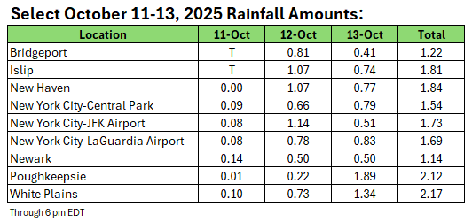
- Today
-
 Major coastal flooding in southern Queens and along the south shore of Long Island
 -
wow massive flooding near Jamaica Bay both in southern Queens and SW Nassau. I have to wonder how much of this is because of climate change induced sea level rise? This storm, while strong, didn't seem to be strong enough to cause such a surge! Major flooding in Lindenhurst too.
-

Spooky Season (October Disco Thread)
Ginx snewx replied to Prismshine Productions's topic in New England
First big snows NNE elevation Oct 20th within a day or 2 -
if a pop-up shower for 30 seconds in April is your thing, do it
-
yes