All Activity
- Past hour
-
Yes. It will be interesting to see how it fares in coming days.
-
We got Josephine
-
 mixing gabapentin and soma: gabapentin for chronic daily headache - therapeutic dose gabapentin pain
-
I’m expecting a record mild winter imby using some farmers almanac type logic. The warmest winter on record in Minneapolis was set in 23/24 while my wife was pregnant with our second child. This winter she is pregnant with our third.
-
I’ve ignored him years ago….
-
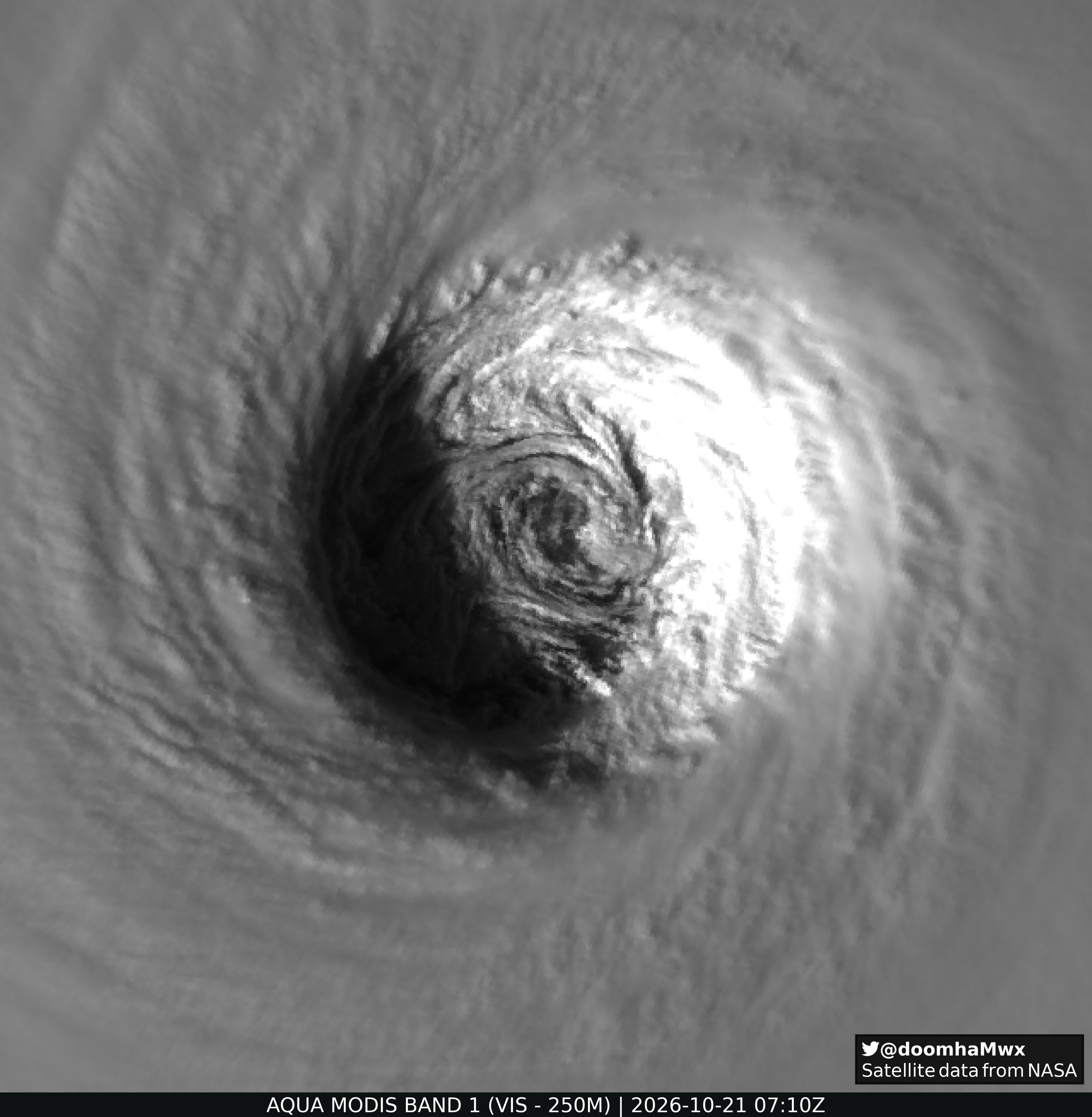
Special Tropical Weather Outlook NWS National Hurricane Center Miami FL 340 PM EDT Wed Oct 21 2026 For the North Atlantic...Caribbean Sea and the Gulf of America: Special Outlook issued to raise formation probabilities for AL93 Offshore of the East Coast of the United States (AL93): Updated: Shower and thunderstorm activity has become better organized in association with a storm-force low pressure area located a few hundred miles off the mid-Atlantic United States coast. The system has continued to acquire subtropical characteristics today and has become separated from fronts. If these trends continue, a subtropical storm could form later this afternoon or tonight while it accelerates northeastward. Regardless of the status of the system, high winds, coastal flooding, and dangerous surf are expected along portions of the U.S. East Coast during the next few days. For more information, including hurricane-force extratropical wind warnings, please consult statements and warnings from local National Weather Service offices and the Weather Prediction Center, along with the High Seas Forecasts and the Storm Warnings issued by the National Weather Service. * Formation chance through 48 hours...high...70 percent. * Formation chance through 7 days...high...70 percent. Evidently, this was already declared STS Josephine just a few minutes ago. ———————— 12Z UKMET was still another having run it even though the text technically called it a TS (I don’t think it is capable of distinguishing T from ST): TROPICAL STORM 93L ANALYSED POSITION : 36.7N 69.0W ATCF IDENTIFIER : AL932026 LEAD CENTRAL MAXIMUM WIND VERIFYING TIME TIME POSITION PRESSURE (MB) SPEED (KNOTS) -------------- ---- -------- ------------- ------------- 1200UTC 21.10.2026 0 36.7N 69.0W 995 44 0000UTC 22.10.2026 12 37.5N 69.4W 991 47 1200UTC 22.10.2026 24 38.8N 68.4W 985 49 0000UTC 23.10.2026 36 39.9N 65.1W 984 66 1200UTC 23.10.2026 48 41.4N 59.5W 982 61 0000UTC 24.10.2026 60 43.0N 56.6W 986 51 1200UTC 24.10.2026 72 43.0N 54.8W 990 46 0000UTC 25.10.2026 84 42.8N 51.4W 994 41 1200UTC 25.10.2026 96 41.7N 45.7W 1004 38 0000UTC 26.10.2026 108 CEASED TRACKING
-
buy zithromax online or zithromax online zithromax order online uk http://www.boosterblog.net/vote-146-144.html?adresse=zpacksupply.com&popup=1 zithromax purchase onlineor http://bbs.51pinzhi.cn/home.php?mod=space&uid=8475323 zithromax 250 mg [url=http://clients1.google.bt/url?q=https://zpacksupply.com]purchase zithromax z-pak[/url] buy zithromax canadaor [url=https://brueckrachdorf.de/user/mfmofrsbno/]zithromax online[/url] zithromax z-pak
-

Yellow Medicine County, MN - Climate Fact or Climate Fiction?
Cobalt replied to Cobalt's topic in Climate Change
Sep 2026 data is still yet to come in for Yellow Medicine County, Minnesota (Population 9,477), but the trend from past Septembers indicates that the month is among the fastest warming. Increases in both high and low temperatures are to blame.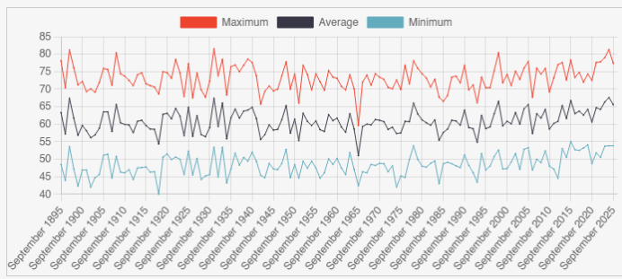
-
ISP hit 59, warmer here at 63
- Today
-

E PA/NJ/DE Autumn 2026 Obs/Discussion
ChescoWx replied to PhiEaglesfan712's topic in Philadelphia Region
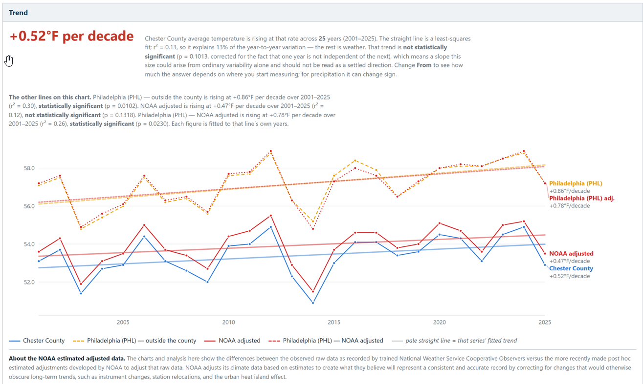
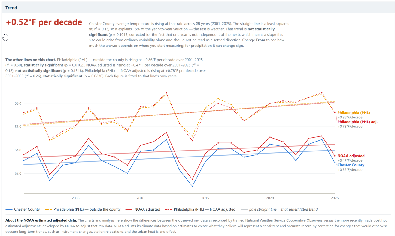
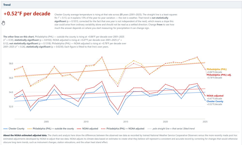
Over the last 25 years, Since 2001 PHL Airport warming is statistically clear in both its raw and NOAA-adjusted records. By comparison here in the nearby philly burbs of Chester County PA our warming is less or about 40% smaller than the PHL heat island. The warming across Chester County has not been statistically significant using either the raw or NCEI adjusted data over the last 25 years! The gap between the two (+0.34°F/decade) is consistent with an urban/airport effect. One more point of interest: NOAA’s data adjustment only trims PHL’s trend slightly (0.86 → 0.78). So, importantly whatever UHI warming that is in the airport record over this window, the homogenization is removing very little of it!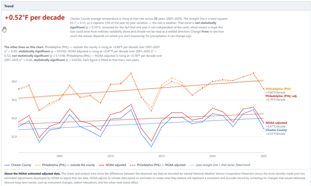
-
don't you just love when the oak leaves blow around on top of snowpack and settle into footprints and snowmobile tracks. ruins a beautiful pack
-
Over the last 25 years, Since 2001 PHL Airports warming is statistically clear in both its raw and NOAA-adjusted records. By comparison Chester County’s warming is about 40% smaller and not statistically significant using either the raw or NCEI adjusted data. The gap between the two (+0.34°F/decade) is consistent with an urban/airport effect. One more point of interest: NOAA’s data adjustment only trims PHL’s trend slightly (0.86 → 0.78). So, importantly whatever UHI warming that is in the airport record over this window, the homogenization is removing very little of it!
-
I'm moving up to Barns Corner, Tug Hill on Dec 1. I'm looking at forward to learning all the different species of trees up there. I know all the trees here in Maryland. I can identify trees by the bark, leaves, and crown shape. While I'm playing in the snow I'll be studying the different trees species. Sorry so the banter. I get excited when fokes talk about trees.
-
Exactly. I pointed this out a couple weeks ago and got weenied for some reason...but it's true! I mean in any winter the prime window always starts around that time anyway.
-
Maybe nobody feels like doing it, hahaha
-
It's basic climatology driving this. The oceans have so far acted as the heat sink for the increased radiation that the strengthened greenhouse effect back-radiates to Earth. This is because their heat capacity is so much larger than air, and they release this heat in the form of latent/sensible heat flux when cold airmasses move over them in fall/winter. If you keep warming up the oceans it takes longer for them to cool off in fall and therefore you get increased temperatures from the latent/sensible heat flux off them. Our December warming is an exam question becoming reality.
-
https://zpacksupply.shop/# zithromax without prescription
-
2026 Atlantic Hurricane Season
NorthHillsWx replied to Stormchaserchuck1's topic in Tropical Headquarters
93L looks subtropical. Looks much more tropical in nature than the last nor Easter everyone was freaking out over on social media. This one is actually maintaining convection over the center, has highest winds in central convection, and is over the Gulf Stream -
61/41 AWT breezy here, closed the garage door to keep the leaves out
-
https://gabarxdirect.com/# gabapentin 300mg capsule
-
Who is running the snowfall contest this year?
-
Yeah as long as there's something interesting to track from time to time. Long-duration dry patterns are the worst.
-

2026-2027 Record-breaking El Nino
rclab replied to Stormchaserchuck1's topic in Weather Forecasting and Discussion
And yet within days of an impending frozen event when a serious fyf Meteorologist enters the storm thread we grow quiet, in rapt attention, for the word…. Hammer not withstanding. As always …. -
order accutane overnight delivery: dermatretdirect - isotretinoin online prescription free