All Activity
- Past hour
-
Trends continue with a reduction in precip. No surprise here, as the main rain area is well North of the forum.
-
-

2025-2026 ENSO
michsnowfreak replied to 40/70 Benchmark's topic in Weather Forecasting and Discussion
I absolutely love Fall. Took that pic yesterday pn an impromptu walk in the park. I dont mind the leaf cleanup in the crisp chilly air at all. I'll do that 100x rather than cut grass on a humid July day. -
-

Spooky Season (October Disco Thread)
wxeyeNH replied to Prismshine Productions's topic in New England
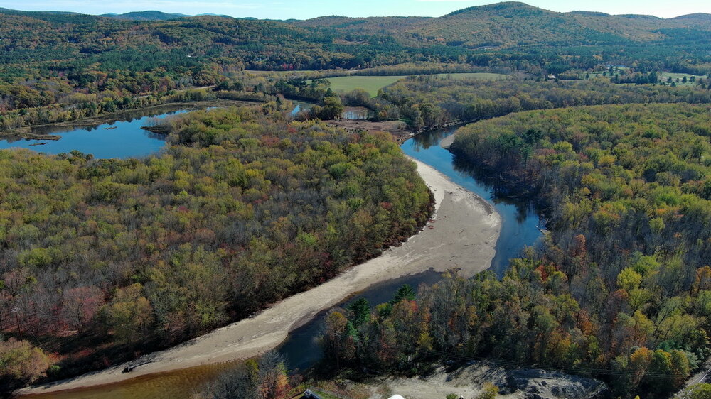
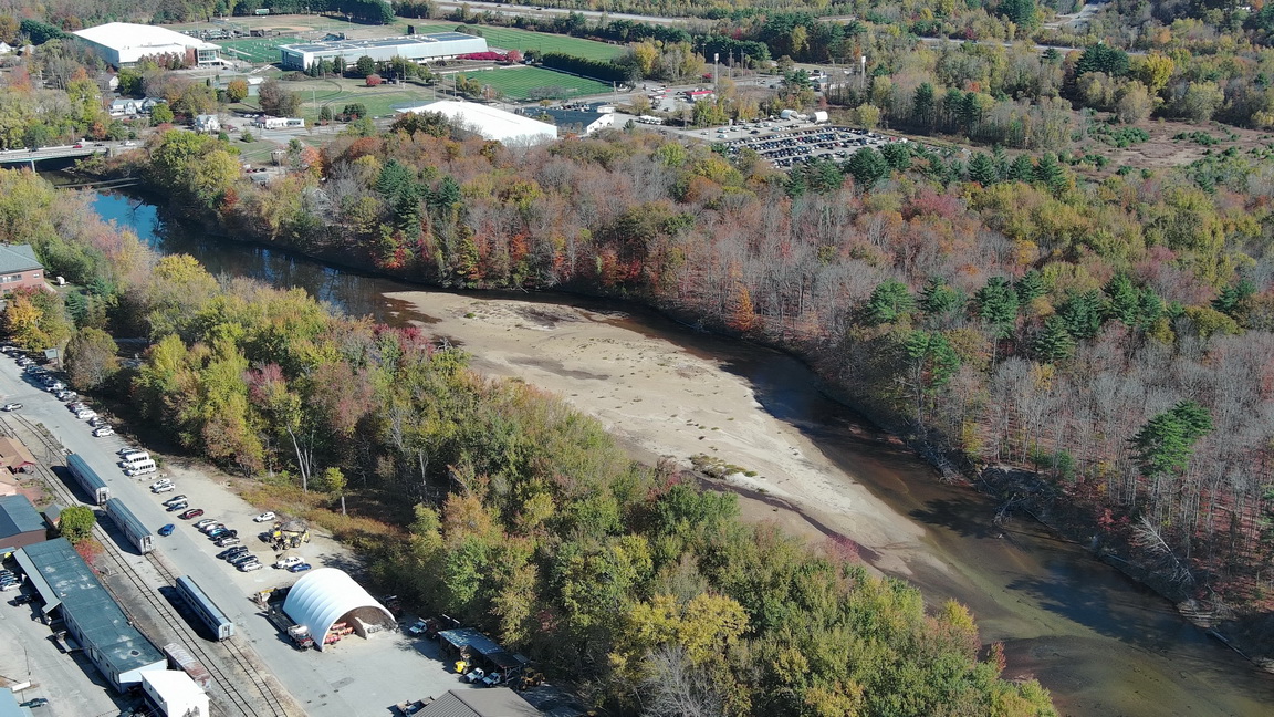
I was in Plymouth, NH today which is one town north of where I live. I decided to fly the drone over the Pemigewasset River. The river is basically just stagnant bodies of water. I could not see any flow. The first picture is where the river normally floods. Amazing drought. Finally, things look to change. I'm glad we will get some water into the system before the surface freezes. Also, there has been no real foliage season to speak of.
-
Sipping an Ardbeg Wee Beastie 5 yr old single malt Scotch whiskey before going out with the blower to dispense with the first round of leaves. It's Fall for real.
-
It’s been stuck in hyperdrive for the better part of a decade now. Any insights on how long things like this usually last?
-
Foliage is over 50% changed out this way; the town is filling up with those looking to get the fall vibes.
-
I think it's way to soon to be giving up on winter currently. The models cannot even get past 5 days correct let alone the next several months correct. We have a weak pv currently and the Eurasian snow cover is currently looking really good. I'm an optimist though this winter so we will see but I like our chances.
- Today
-

Mid to long range discussion- 2025
WinstonSalemArlington replied to wncsnow's topic in Southeastern States
First freezes soon ahead? -
The longer range hi-res guidance is adverting a Narrow Cold-Frontal Rain Band (NCRFB) like feature for Sunday evening. This makes sense given the high shear / low (no?) instability. If we can't get proper severe, at least a NCRFB is "cool" meteorologically.
-

Occasional Thoughts on Climate Change
LibertyBell replied to donsutherland1's topic in Climate Change
Elephants, Orangutans and some other animals can also prognosticate doom. Elephants literally headed for the hills when the Indonesian tsunami approached while humans were mindlessly sunning themselves on the beach. Many animals can detect earthquakes before they happen, a notable example were the orangutans at the National Zoo before the 5.8 earthquake in August 2011. -
I'm still trying to figure it out, lol
-
-

Spooky Season (October Disco Thread)
weathafella replied to Prismshine Productions's topic in New England
Kevin, 50s on your bday is climo. However it’s the flavor that makes it feel warm. Unending blah but to be fair summer is over, ac is definitely done and the heat occasionally kicks on especially overnight. There have been a few ensemble runs (gefs mainly) that have hinted at a dateline ridge developing. That would be in time for some to be dumbfounded. -

Central PA Fall Discussions and Obs
Itstrainingtime replied to ChescoWx's topic in Upstate New York/Pennsylvania
Sneaky run at 80 tomorrow east of the river. -

Spooky Season (October Disco Thread)
kdxken replied to Prismshine Productions's topic in New England
Let's keep this going please..thumb.jpg.2368842f4c6ef28a5cff9373fa89c315.jpg)
-
I like Wxbell's graphics the best....SV has just always had the best loading time, but that gap maybe closing.
-

2025-2026 ENSO
40/70 Benchmark replied to 40/70 Benchmark's topic in Weather Forecasting and Discussion
I see what you are saying, but this is worse IMO....mischaractrerizing a storm due to mesoscale banding is more forgivable than lumping an entire season in with some of the least snowy when it was one of the more prolific just to the north. -
A bit of a hyprocrite aren't you? You are cluttering up this thread with Chester County charts. Are you saying that your arguments are poorly constructed because the Chester County data is independent of the rest of the world? You can't have your cake and eat it too. If Chester County is relevant to the rest of the world; Philadelphia, Allentown and Newark Ag station are relevant to Chester County. In any case the science is clear on this point, weather data is correlated for hundreds of miles. Chester County doesn't cool when the surrounding stations don't. In fact, as I showed in the Chester County thread, there is a very good match in the warming rate at the airport and individual Chesco stations. Finally we don't need any data outside of Chester County to know that Coatesville cooled significantly after the war. The tables posted above show that Coatesville cooled relative to Phoenixville and West Chester after 1945 and Phoenixville cooled relative to West Chester and Coatesville between 1948 and 1949. The data from outside Chester County merely confirms what the Chester County data is already showing.
-

Central PA Fall Discussions and Obs
Blizzard of 93 replied to ChescoWx's topic in Upstate New York/Pennsylvania
Look who made an appearance in the Mid Atlantic Winter preview thread… No one else has posted since in there…
-
As of now, barring any drastic changes, the main Climate Driver Data extrapolated for the Winter suggests a strong SER presence. Of course, blocking is tough to factor in. If that were to manifest then things could be different...unless there's the SER -NAO Linkage. If you're a cold/snow lover like me it doesn't look good. As far as economically, it would be great as utility prices as well as other basic needs continue to rise. Many are having trouble making ends meet.
-
I had some scattered wind overnight that kept me over 40 like you, I assume you had the same.
-
Love the fall colors, but as soon as the leaves start dropping, all I think about is that its a month of heavy yard work coming haha.
-
50 is chilly in a little floating basket I would think. My dog spotted it and wouldn't stop barking at it. Thankfully it landed soon after I took the pic.


.jpg.5c78afd89a6c07415b892ae060492924.jpg)