All Activity
- Past hour
-

November 2025 general discussions and probable topic derailings ...
weatherwiz replied to Typhoon Tip's topic in New England
have a few flakes falling first of the season unless I missed any last night. -
Matching the recent pattern of more narrowly focused Arctic outbreaks into smaller geographic regions than we used to get. The November 1976 Arctic outbreak was a longer lasting one and covered much of the East with record cold. Reminds me a bit of the Great Lakes record cold in January 2019 which was short-lived and didn’t extend to the East with its most impressive cold. Also the February 2021 Arctic outbreak which stayed in the Plains.
-
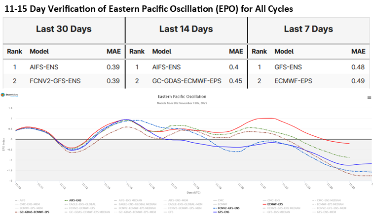
Commodity Wx Group @commoditywx Models debating speed of -EPO arrival with American fastest and European slowest; both have exhibited competitive skill in past 30 days, but AIFS ensemble middle ground may be best answer.
-
 Installing a 26kw Generac in Wrentham today. Windy and cold with some stray flakes. Lovely
 -
I believe that flare would hit Wednesday or Thursday night while the one tonight is seperate
-
-
 I would pay attention to this guy. He never has anything positive to say. He only pops on every so often to spew out some negative crap that makes no sense whatsoever.
 -

2025-2026 ENSO
PhiEaglesfan712 replied to 40/70 Benchmark's topic in Weather Forecasting and Discussion
12/19/2009 to 2/10/2010 is the only one that really rivals 10-11. I highly doubt we're ever going to have a stretch with so much snow in very little time like those two winters. If we're going to have a high snow season, it will be more sustained throughout the season, like 2013-14 or 2014-15. -
Dep through the 1/3 of Nov (10th) EWR: +3 JFK: +2.2 NYC: +2.2 LGA: + 1.9
-
First freeze of the year. 31
-

November 2025 general discussions and probable topic derailings ...
Ginx snewx replied to Typhoon Tip's topic in New England
5 to 7 years? Jesus your memory sucks. -
November 2025 general discussions and probable topic derailings ...
Ginx snewx replied to Typhoon Tip's topic in New England
Congrats on getting on the board.
-
 It’s been the worst and most boring 5-7 years of my life. Just brutal . Very little snow , severe, no tors , no canes in a lifetime .. just awful. And there’s no reason to think that will change despite the excitement from the master motivator
 -
 Official first flakes flying at various times today. Low was only 29, forecasted to be 25, 34/22 currently.
 -
Impressive, but next week we warm up.
.thumb.jpeg.b0ec21daf2aea4dda1d881d1acfc8b6d.jpeg)
-

E PA/NJ/DE Autumn 2025 Obs/Discussion
JTA66 replied to PhiEaglesfan712's topic in Philadelphia Region
Flurries! It begins -

November 2025 general discussions and probable topic derailings ...
ineedsnow replied to Typhoon Tip's topic in New England
YES! -
We snow here
-
Followup to the above based on lowest hourlies through 7AM (I’ll update this if any official lows turn out to be lower):These appear to be the lows along with the model that was closest out of the 11/7 6Z GFS/ICON/Euro runs and 11/7 0Z UKMET/CMC runs:SAV: 28/ICONNE ATL: 28/EuroGSP: 23/ICONCAE: 29/ICONCLT: 29/CMCRDU: 30/ICON, Euro, GFS tied-Avg of these: 27.8, which is significantly colder than my guess of 30.5-So, although the CMC was closest to only 1 of the 6, it’s average of 28.5 followed by ICON’s 26.3 were closest to the 27.8 actual-UKMET’s 32.6 was easily the furthest-So, ICON, alone, was closest to 3 of the 6So, ICON and CMC did the best overall due to being the coldest while UKMET was the worst due to being the warmest
-
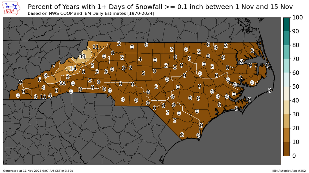
Gives you an idea of how rare snowfall of any amount is outside the mountains in the first half of November (this data set is 1970-2024)
-
Low was 33.
-

Central PA Fall Discussions and Obs
WmsptWx replied to ChescoWx's topic in Upstate New York/Pennsylvania
A few flakes falling here in Huntingdon county. Christ the weather is boring here lol. -
25 degrees this morning here, now up to 29. Flurries on and off. Had some awesome and intense graupel and flurries yesterday. NW of Staunton in Augusta County
-
If Atlanta gets November flurries then there’s no way we’ve reached the point where we’ve permanently lost the 1996, 2003, 2016 tier storms.
-
 KJRB: Manhattan/Wall Street Heliport, NY, United States [43kt, 22m/s] KRSP: Campd David, MD, United States [49kt, 25m/s] Within the past couple hours. Heliport elevated but the idea is there. Supports the Queens ob of 45 MPH (39kt)


.jpeg.8a7c29139f54f137cbad696fcbd5801a.jpeg)


