All Activity
- Past hour
-

Ice Ice Baby December 28-29 Storm Discussion
ORH_wxman replied to Baroclinic Zone's topic in New England
I dunno, I really think it depends how long temps are above 40F…in your area to my area, there’s a decent chance it wipes the pack. Prob gonna be 12+ hours of 40+ dews. Not a lot of water in the pack either (though my bottom layer from 12/23 is kind of dense). Western CT up into ORH county might keep it though as they spend less time above 40F. If we had like an inch of water in the pack then this wouldn’t wipe it out, but this is not that type of pack. -
Faked our way to 1.8⁰ this morning, looks like KOXC hit 10⁰...off to PA for a couple days, beautiful wintry morning....will look completely different went we return. Hope we still have some coverage left, but doubt it.
.thumb.jpg.35eb834c05c61d6c8dfb52d615831e09.jpg)
-

December 2025 regional war/obs/disco thread
Snowcrazed71 replied to Torch Tiger's topic in New England
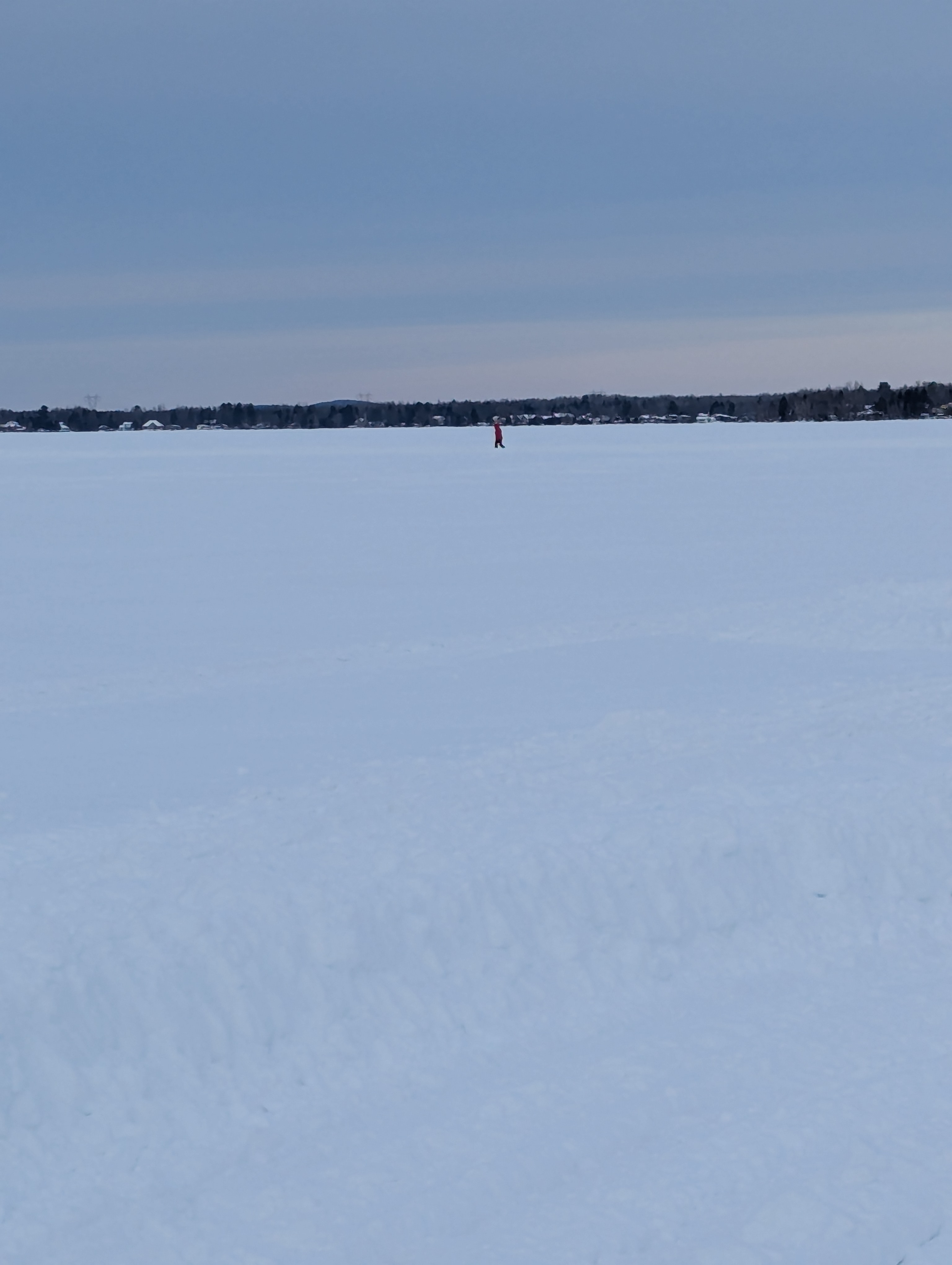
Currently -1° up here in Shawinigan Quebec.... Lake is frozen... They made a large path to walk, ice scate and Snow mobile on the lake. Pretty awesome
-
23 / 21 clouds buildin in. Mid / upper 30s today - rain overnight (mix to start in some spots NW). Warmest of the next 7 (at least) on Monday with rain / wind. Cold overall and reloading in the 1/5-1/6 timeframe and beyond it might be towards after the middle of the month before moderation / wamer. As currently looking on: 12/28 - 29 : Warmer / rain 12/30 - 1/3 : Cold (potential snow/ice 1/1 - 1/2 1/4 : Trough building in 1/5 - 1/6 and beyond : Much colder / storms around that timeframe
-
Probably same here when we saw 1 this a.m. an hour later it was reading 9
-

Central PA Winter 25/26 Discussion and Obs
Mount Joy Snowman replied to MAG5035's topic in Upstate New York/Pennsylvania
My current temp of 29 hasn’t budged all through the night. -

Ice Ice Baby December 28-29 Storm Discussion
dendrite replied to Baroclinic Zone's topic in New England
The SN/IP zone in Maine kinda gets bullied, by the WAA…not something I like to see for going big ice in CNE. HRRR has MHT below 32° for the entirety…hard sell on that. I think it’s underestimating the diabatic latent warming and the lack of Tip’s +PP. -

Ice Ice Baby December 28-29 Storm Discussion
AstronomyEnjoyer replied to Baroclinic Zone's topic in New England
Here ya go. 12z HRRR FRAM est.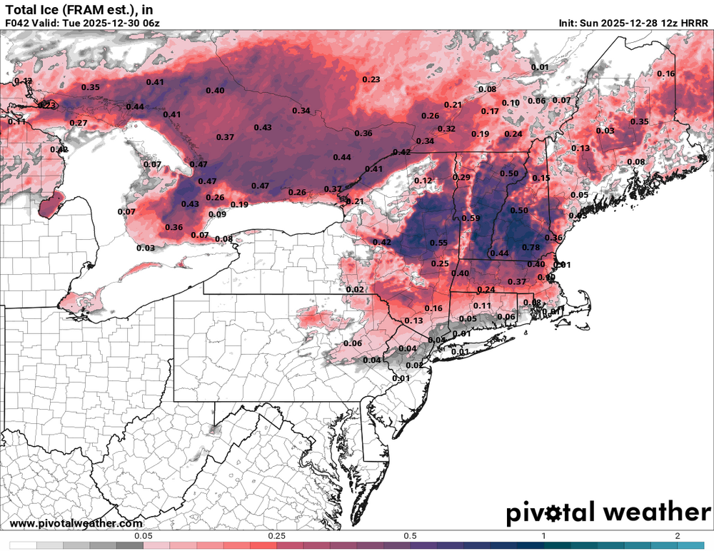
-
Managed to get maybe 3/4" out of that. Sadly, 2nd highest total of the season.
-
 kristia changed their profile photo
 -
January 2026 regional war/obs/disco thread
dendrite replied to Baroclinic Zone's topic in New England
Hopefully it’s not congrats DC, but at least there’s no monster PNA in the extended. I’ll roll with that block. -
January 2026 regional war/obs/disco thread
ORH_wxman replied to Baroclinic Zone's topic in New England
Gonna be a miller B while you’re gone just to give you one more round in Ray’s beast shed. -

Ice Ice Baby December 28-29 Storm Discussion
Damage In Tolland replied to Baroclinic Zone's topic in New England
Do you think it’s a pack wiper ? -

Ice Ice Baby December 28-29 Storm Discussion
Prismshine Productions replied to Baroclinic Zone's topic in New England
Anybody got the FRAM actual ice equivalent?... Iirc isn't the ratio for ZR:QPF something like .5:1? Sent from my SM-S166V using Tapatalk -

January 2026 regional war/obs/disco thread
CoastalWx replied to Baroclinic Zone's topic in New England
Yeah looks great after the 6th or so. -
Gearing up for between .1-.25 of ZR before any rain, well up north might be in for a legitimate ice storm. Doubt we see 50 tomorrow but 40s sounds more realistic
-
Ice Ice Baby December 28-29 Storm Discussion
ORH_wxman replied to Baroclinic Zone's topic in New England
I also don’t think the accretion will be overly efficient in this type of setup. When the cold layer is so shallow like this, the liquid drops are not as supercooled so they won’t freeze as quickly on contact. In icing events where we have robust cold up into the 925-950 layer, that’s when the accretion is usually much more efficient. It prob will start pretty icy but then then it will get pretty marginal. -
Ice Ice Baby December 28-29 Storm Discussion
Prismshine Productions replied to Baroclinic Zone's topic in New England
ASM for Dollar Tree during holiday season... My absence is valid Sent from my SM-S166V using Tapatalk -

Wounded Duck Strikes Back: Dec 26 & 27th Winter Storm Obs
WinterWolf replied to WxWatcher007's topic in New England
I hope you post here more often…great stuff. And very good perspective. Ive said as much, and couldn’t agree more. -
Given the amount of rock salt and calcium they dumped all over the roads yesterday, I doubt we see a big widespread freezing rain fest. It takes very anomalous conditions for those anyway and that’s why they are so rare around here
-
I went over to TT and put the 5H anomalies in motion with the slid function. I looks like the lowest anomalies backed in from the east and not from west to east. Idk if it makes a difference, but I was expecting it to move from west to east. I'm not saying it's bad, because I don't know. Maybe a red tagger can chime in. https://www.tropicaltidbits.com/analysis/models/?model=eps®ion=us&pkg=z500a&runtime=2025122800&fh=12
-
BWI: 37" DCA: 19.5" IAD: 14.5" RIC: 24" SBY: 18"
-
Yep, that’s all we can take away at this moment. Jan 5-12 is still what I’m cautiously optimistic about, and the pattern still looks good after. There may be a couple/few days where we relax or warm up, but we have not lost this yet.
-
Declaring the second White Christmas in a row is much more complex than just measuring snow. At 7am Christmas morning I would say for sure it was a white Christmas. The viewable area from my house had at least a one to two inch snow cover over 80% of the land mass which is my criteria for snow cover. However as you yourself stated our current snow has staying power, the snow consistency from the 23rd did not. By noon on Christmas Day snow coverage was less than 50% and by sunset 20%. How is that really a White Christmas? And there we have the White Christmas Paradox. How is it a white Christmas when more than half the day is green? The Fermi paradox may be answered before this. I'm considering changing my declaration of this year being a White Christmas. No question about today's snow cover. After a morning low of 9 snow cover at 5.5. I believe the consistency and LE of the current snow pack will easily survive our rain tonight and mid 40's tomorrow.
-
-2 at AFN while ORH is 20F. About as fake as it gets, lol. But there will def be some stubborn cold overnight tonight that will cause icy spots.
-

Ice Ice Baby December 28-29 Storm Discussion
wx2fish replied to Baroclinic Zone's topic in New England
Skeptical of the HRRR, but verbatim the 12z run is 3/4" qpf as freezing rain across SNH. My guess is its a little too cold, and itll be a faster rise to around 32 for many. But, something to montior today.

.jpg.760f4b43ec8477b21e3814a524b32182.jpg)