All Activity
- Past hour
-
B+ so far. 15" of snow is good, but it being so powdery was disappointing. Would have been an A+++++ year if the ice storm hit like the sledgehammer that it was supposed to be.
-
 I'm really seeing how extreme it looks on models. The last few days I was thinking the seasonal pattern of -AO may be enough to overcome it, or help the ridge go poleward hooking up, eventually, but today's models really went south. The classic measurements aren't going to have super low readings, but the 12z EPS has +400dm on the mean, with a trough over top of it in Alaska. What happens in Alaska and NW Canada has a lot to do with what happens with the PNA downstream too. Since 1998, we have been in this pattern of more troughing over AK/NW Canada vs the 1960s. NAO ridging isn't strong enough to cancel out that strong Pacific pattern, once the pattern change happens quickly in 4-5 days.
 -

Friday February 6 FROPA / WINDEX small event
bristolri_wx replied to HoarfrostHubb's topic in New England
Congrats Albuquerque? -

2025-2026 ENSO
michsnowfreak replied to 40/70 Benchmark's topic in Weather Forecasting and Discussion
April is one of my least favorite months (Apr and Aug). I was recalling recent April snowfalls and frigid Opening Days moreso than the monthly temp departure. A closer look shows that in the last 10 Aprils, 4 were colder than avg, 1 avg, 5 warmer than avg. But regardless my stance remains. Calling for a torch month 2 months out with no basis other than a gut feeling is automatically wrong. I wouldn't have even responded if someone said "id lean warm for April". But torch? Ill wait and see. -

Friday February 6 FROPA / WINDEX small event
dendrite replied to HoarfrostHubb's topic in New England
Just post the mean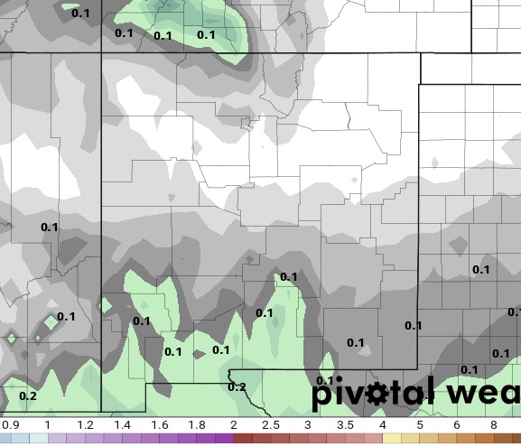
-

February 2026 OBS & Discussion
coastalplainsnowman replied to Stormlover74's topic in New York City Metro
Anyone remember the old wind chill tables pre 2001? Some of those numbers seemed ridiculous even at the time. Under the old wind chill system, on Saturday night, the predicted 4 degree temperature for me would result in a wind chill of roughly -45 during a 40 mph max predicted gust, vs. the -22 in the current tables. The "Freezer Bowl" playoff game in 1982 between the Bengals and Chargers featured a -9 game time temperature and 35 mph gusts. As reported at the time, the wind chill was -59 at the time, and based on the tables seems it would have been even lower. Today, it would be a relatively mild -41. -
 @Stormchaserchuck1 the last 10 years a hostile EPO/PNA is a killer and been game over but historically that’s not always been true. We’ve had plenty of snowstorms without an EPO PNA ridge. But it depends on several things. 1) the antecedent thermal profile across N America. If the continent is torched it won’t work. 2) AO/NAO without blocking up top and a favorable Atlantic pattern it’s game over. 3) the depth of any PNA trough. Factors 1&2 can overcome a -1 PNA. If the PNA ends up -3.5 it’s probably game over. So I’m not saying you’re wrong but it’s not as simple as “we lots the EPO PNA game over”. If those 3 factors go our way we can still snow. But the last 10 Years everytime the pna went wrong everything else went wrong too. And if we did have some blocking help the PNA went some crazy -4 or something which is impossible to overcome, especially earlier in the season which some of those cases were. So curious…do you see wings the PNA is going so hostile, or that those other factors will also ne unfavorable…or are you ignoring everything else and just looking at the PNA. Because while the PNA has been a great single indicator recently it’s not always been that way and hopefully doesn’t continue to be because some of our best snowstorms came with a -PNA
 -
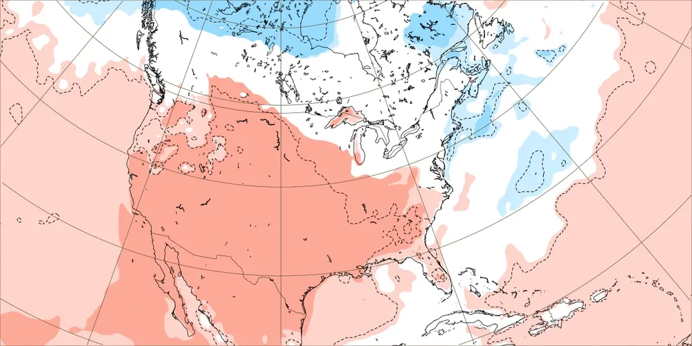
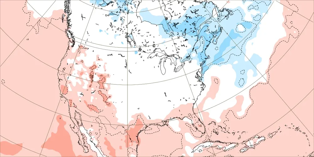
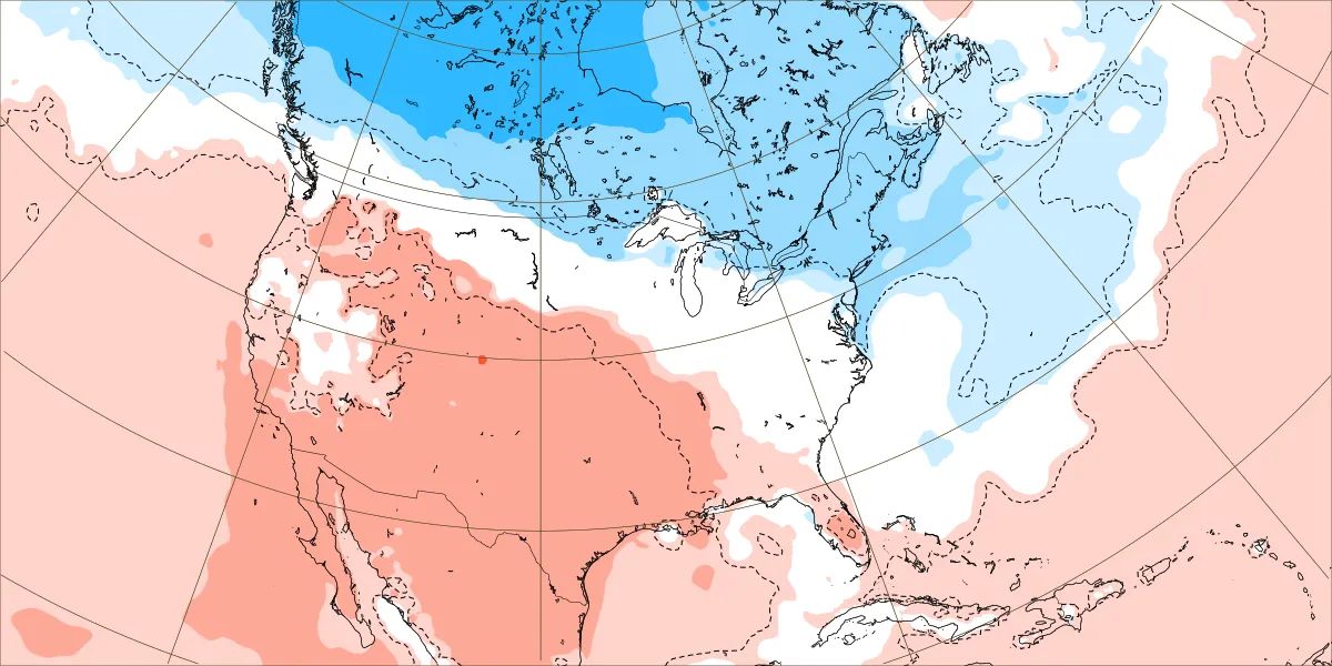
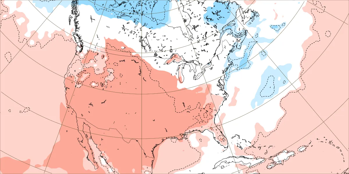
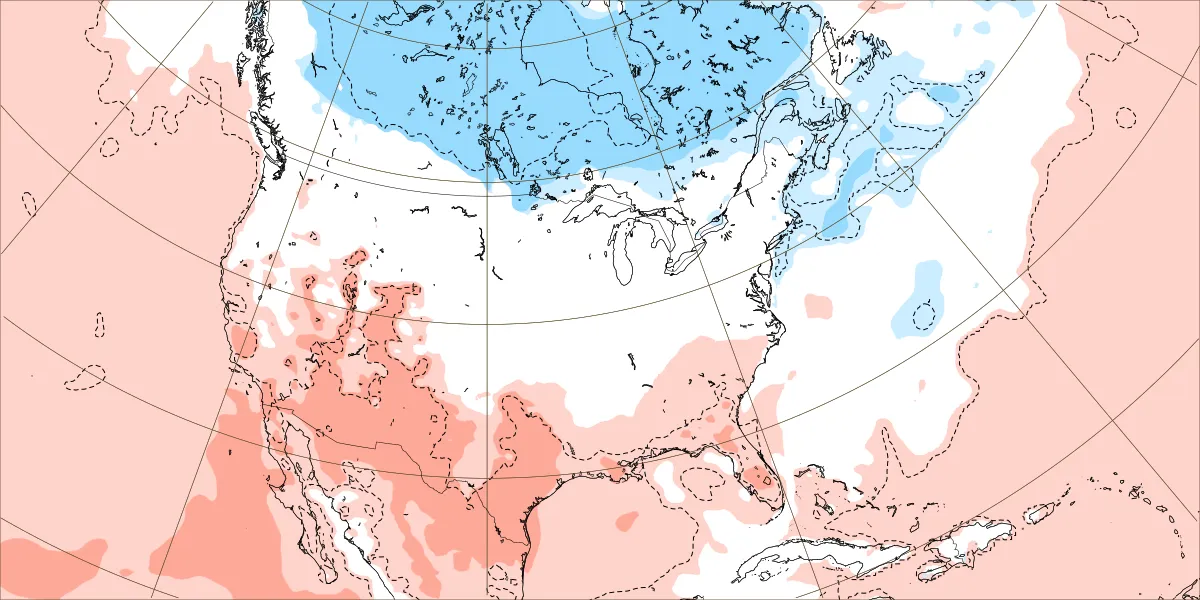
Anthony, It’s important to be aware that the WxBell Euro EW 2m maps have a notable 2m temp cold bias as I’ve posted about repeatedly. I have an easy way to show this by posting the in-house ECMWF weeklies covering the same period and comparing to this WxBell map. Examples: -The Rockies and west coast are a very cold -3F to -10F for 2/21-3/22 on your map. What?!? -Chicago/OH Valley are -2F, Asheville is -3F, Detroit is -4F, DC/Richmond are -3F, ATL/CLT are -1F. - Now check out the ECMWF’s in-house maps for the truth: no BN on any of the maps covering the same period for the locations I listed 2/23-3/1: 3/2-8: 3/9-15: 3/16-22: So based on the truth, the Rockies and much of the West should be a bit AN instead of well BN. So, that means they’re mainly 5F to 10F too cold on WxBell! The E cities I listed should be NN in Chic, Det, Ohio Valley, DC, Richmond, and ~+1F in ATL/CLT/ASH. So, that means that these locations are 2-4F too cold on WxBell. WxBell has NYC at -4F. The truth is that they should be ~-1F. So, NYC is 3F too cold on WxBell. @donsutherland1this remains a problem


-
High of 34. With the sunshine it actually felt warm out.
-
Made it to 37 here. Was able to take the sweatshirt off for a short 10min stint today.
-

Is we back? February discussion thread
Damage In Tolland replied to mahk_webstah's topic in New England
I’ve felt that was the only game in town next week . Maybe the weekend deal comes back , but try mid week deal has been solid signaled. -
Here's a fun one - the last time that DCA (current airport location) had a consecutive week below freezing with at least 5" of snow on the ground was...never. 1989 had a longer streak, but less snow on the ground (2-4") 1979 had a similar streak, but some of the days had 4" 1961 had a 13 day stretch where it hit 33 twice (3-9")
-
Hell yeah! I absolutely LIVE FOR THIS! I must say tho my offer to go tubing at Canaan Saturday night hasn't had many takers, unfortunately. I've promised the hubby a puppy if he'd go but given he's been outside 10 hours a day for weeks on end at Wisp, even the promise of a lil muffin isn't moving the needle. If anyone is around, lemme know and I'll pay for the ticket lol.
-

February 2026 Medium/ Long Range Discussion: 150K Salary Needed to Post
CAPE replied to Weather Will's topic in Mid Atlantic
A mix. Some focus more on the 12th. A lot have nothing, some rain, a few snow south. Plenty of spread as expected at this range. -
Earth-2 Global Data Assimilation (Coming Soon) The Earth-2 Global Data Assimilations model generates precise initial atmospheric conditions in seconds on GPUs rather than hours on supercomputers. When coupled with Earth-2 Medium Range, it delivers the most skillful forecasting predictions produced by an open, entirely AI pipeline. https://resources.nvidia.com/en-us-climate/earth-2 it's vibe-coding at some point. it's fun to mess around with if you have a higher-end RTX
-
I like the way you think! Pretty sure we'll at least try to get to Davis tomorrow afternoon. Don't have a death wish, so we'll see but there is nothing like a solo drive on 90 getting to Thomas in the snow from Oakland. I think that ~13 mile stretch might be my favorite drive around here. Had a nice visit to Stumptown a few weeks ago and if we're in the hood, we'll stop by again.
-
18z EPS starting to like the 11th
-

Friday February 6 FROPA / WINDEX small event
JACKASS replied to HoarfrostHubb's topic in New England
D- Thanks for trying. -

Central PA Winter 25/26 Discussion and Obs
pasnownut replied to MAG5035's topic in Upstate New York/Pennsylvania
Fixed - Yesterday
-

Friday February 6 FROPA / WINDEX small event
WinterWolf replied to HoarfrostHubb's topic in New England
You JACKASS. -
The small amount of meltwater dripping from the roof during the day has been freezing in front of the front door as it falls, not only after sunset. Those bricks are cold and slick. I broke a vow and threw a little salt on them.
-
 For all the duds is it too warm or just no storm at all?
 -

Is we back? February discussion thread
40/70 Benchmark replied to mahk_webstah's topic in New England
@Torch TigerJust as you were, just posting what it shows. -
Friday February 6 FROPA / WINDEX small event
JACKASS replied to HoarfrostHubb's topic in New England
Friday? Tomorrow? -
Friday February 6 FROPA / WINDEX small event
Damage In Tolland replied to HoarfrostHubb's topic in New England
It’s been 2-4” all areas for several days with ratios and some zone is getting 6-10”. Not that it’s correct but Euro has had the same dong zone for several runs now .


.thumb.JPG.418e8a9a2902ae687ec35ff4bc0e038e.JPG)


