All Activity
- Past hour
-

November 2025 general discussions and probable topic derailings ...
kdxken replied to Typhoon Tip's topic in New England
-

November 2025 general discussions and probable topic derailings ...
powderfreak replied to Typhoon Tip's topic in New England
Haven’t gotten above the long term average sub-32 hours at CON in October in like a decade, but we just don’t know why. It could change next year. -
Man moderators have their work cut out for them.
-
-
Down to 31.3 here last night. First freeze!
-
LFG
-
Yeah, because of the variability of this time of year it's both noteworthy and not, ha. It's a time when single storms can jack up the stake depth and then warmth can melt it rapidly... but still interesting that how we feel like it shouldn't be rare, it's still a higher depth than 67 other seasons on the date. But it's funny because in like 3 days it could be nothing to write home; it can change fast this time of year in either direction. Luckily it looks like we should hold it for now.
-
Here are the progs for Nov 11th 7AM temps/lows from the latest ICON/CMC/Euro/GFS/UKMET1. GA-SAV: 29/31/34/34/35-NE ATL: 25/23/29/34/322. SC-GSP: 23/21/29/27/29-CAE: 28/32/33/32/343. NC-CLT: 25/30/31/29/32-RDU: 28/34/32/32/35—————————Average for each model for the 6 cities:ICON: 26.3CMC: 28.5Euro: 31.3GFS: 31.3UKMET: 32.6Any guesses for:1. Which model for the 6 cities averaged out will do best?2. Which model for the 6 cities averaged out will do worst?———————My guesses: 1. Best: Euro/GFS (tie) 2. Worst: ICON
-
Do you have any thoughts regarding the last 4 runs of the CFS for next week?
-

November 2025 general discussions and probable topic derailings ...
ineedsnow replied to Typhoon Tip's topic in New England
That would be great! -
30.0⁰ low here this morning. AoB 32⁰ for 4 hours. That's usually not enough to kill much, but I haven't checked the garden yet.
-
We will see how things look as the weeks tick off. Fast start for us near the coast is always hard to pull off.
-

November 2025 general discussions and probable topic derailings ...
Typhoon Tip replied to Typhoon Tip's topic in New England
So if this Climate tainted version of the GFS model known as the CFS is going to be right ... one would think these 12z runs are going to have to at least start to represent. It's only 84 f'um hours away. There's a bit of an implication there in the 'climate' part - where in the past, this kind of trough/synoptic evolution ended up producing an NJ model quick deepener/ with cold rain over to snows scenario. Why else is this model keep insisting this set up like below. It isn't the first run (0z) that was selling this. But of course we know now that CC's proooobably ruined that from ever happening going forward . It's okay - because CC doesn't exist anyway, right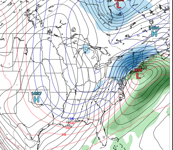
-

E PA/NJ/DE Autumn 2025 Obs/Discussion
Birds~69 replied to PhiEaglesfan712's topic in Philadelphia Region
Woke up around 4:00 a.m. with one eye open and checked the temp. 28F as well. It may have dropped a degree or two after that, I don't know.... -
Yep More people are bullish on a fast start to winter than last winter.
-

2025-2026 Fall/Winter Mountain Thread
WinstonSalemArlington replied to Buckethead's topic in Southeastern States
-
Mid to long range discussion- 2025
WinstonSalemArlington replied to wncsnow's topic in Southeastern States
Phenomenal -

New England 2025 Warm Season Banter
Damage In Tolland replied to bristolri_wx's topic in New England
Lines? Still a few strangers but just about done. All lawn equipment will be done probably by the 20th https://imgur.com/a/YHpDZ2z -
Would you say that the PNA pushing positive despite the +WPO/Pacific marine heat wave is what's behind some of the suppressed storm tracks that gave Louisiana and Florida and SE VA double digit snows? That's just me visualizing the patterns in my head... but I haven't really looked at the PNA data (been heads down with MJO at work lately).
-
Low of 33.9
-
Lot of the green is lines if you look closely. That’s destructionbury.
-

November 2025 general discussions and probable topic derailings ...
dendrite replied to Typhoon Tip's topic in New England
Uhoh he’s posting -
I know this may be more SNE-centric... but i liked seeing this from Will.
-
He's been bullish on this and several others as well as we've been reading here.
-

November 2025 general discussions and probable topic derailings ...
CoastalWx replied to Typhoon Tip's topic in New England
We know why


