All Activity
- Past hour
-
Seabreeze kicked in.
-
Jealous. 59F up here.
-
81 here.. we roast
-
We've seem to be busting low on temps in Albemarle. Clouds stuck around for a while this morning and now we've got some wispy high altitude crud floating by as well. Forecast said 89 but we've only managed 84 as of 2:45pm. Same thing happened yesterday. Forecast was 82, high ended up being 77.
-
Popped up to 84. Pool up to 72
-
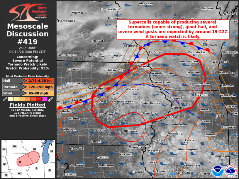
Was wondering if that could possibly be the first PDS watch of the year. Might not be enough to reach that criteria but it could be close.
-
I was in between 6-7 grades. Didn’t bother to go back and look at records but I do remember the family’s annual Myrtle Beach trip first week of June. Everyone was commenting on how unusual it was to be in the 90s. Don’t remember much about the rest of the summer except a lot of Boston, Frampton, Marshall Tucker, and Jimmy Buffet.
-
At least we won't have to wait as long for the next NHL season to start. With the season expanding from 82 to 84 games, the 2026-27 NHL season will start on September 29 and end on April 10: https://x.com/PierreVLeBrun/status/2037514216995787011
-
It's true for sure there. Around here it's the opposite-BDR is right on the water on a penisula so right now it's 76 there but in the low to mid 80's just inland...some of these stations are in places that aren't representative of the weather for most of the area they serve.
-
DISCUSSION...The latest surface analysis depicts a quasi-stationary boundary extending from central/northern IA into southern/central WI, with an additional composite outflow boundary farther south from northeast IA into northern IL. Over the next few hours, continued diurnal heating of a moist air mass (upper 60s dewpoints) should erode remaining inhibition at the base a substantial EML, resulting in the development of strong surface-based buoyancy (upwards of 3000-3500 J/kg MLCAPE). As this occurs, initial thunderstorm development is expected across parts of central/eastern IA near the intersecting boundaries by around 19-22Z -- aided by a subtle frontal wave tracking eastward along the quasi-stationary boundary. The strongly unstable air mass coupled with 40-50 kt of effective shear will favor rapid thunderstorm organization/intensification into semi-discrete supercells and organized clusters. Initially, very large to giant hail (2-3+ inches in diameter) and severe wind gusts will be the main concern with potentially splitting supercells -- given a mostly straight hodograph. However, a south-southwesterly low-level jet will strengthen across the area later this afternoon into the evening and likely favor a transition to dominant right-moving supercells with a quickly increasing tornado risk. The strong buoyancy and 200-300+ m2/s2 effective SRH will support strong to intense tornadoes with any longer-lived supercells, along with a continued risk of giant hail and severe gusts. Eventually, thunderstorms may have a tendency of growing upscale into clusters with eastward extent, which will yield an increasing risk of damaging wind swaths.
-
None of yall are going to see rain the rest of the month. Good luck with the scorpions.
-

2025-2026 ENSO
Stormchaserchuck1 replied to 40/70 Benchmark's topic in Weather Forecasting and Discussion
Kind of funny how the 2nd highest NAO month in all of record happened during a cold season warm Stratosphere -
84 at KFIT - Tip ftw
-
2026-2027 El Nino
Stormchaserchuck1 replied to Stormchaserchuck1's topic in Weather Forecasting and Discussion
Don't know if it's been mentioned here but NOAA March PDO came in at -1.44. That may not seem like much because we've had so much -2 to -4, but -1.44 is still strongly negative. Top 15-20%. -
2026-2027 El Nino
Stormchaserchuck1 replied to Stormchaserchuck1's topic in Weather Forecasting and Discussion
I don't really think El Nino's trigger La Nina's and -PDO's. -
ACY has always been a little misleading to me. The weather stations in town are around 70. The airport is something like 10-12 miles inland. DIX radar shows the seabreeze inching its way inland but at times being pinned to the barrier islands.
-
Atlantic City reached 88° so far. That breaks the daily record of 86° from 1945.
-
As much as I dislike the heat, its hard for me to consider this swamp ass weather with the dews relatively low when compared to what has become normal around here in the summer.
-

2026-2027 El Nino
roardog replied to Stormchaserchuck1's topic in Weather Forecasting and Discussion
Oh no. That means if we get central based event this year it will reinforce the warm pool for the next 40 years. Snowman19 will be posting tweets from Andy Hazelton’s grandkids talking about a SE ridge in 2066. -

Central PA Spring 2026 Discussion/Obs Thread
Voyager replied to Voyager's topic in Upstate New York/Pennsylvania
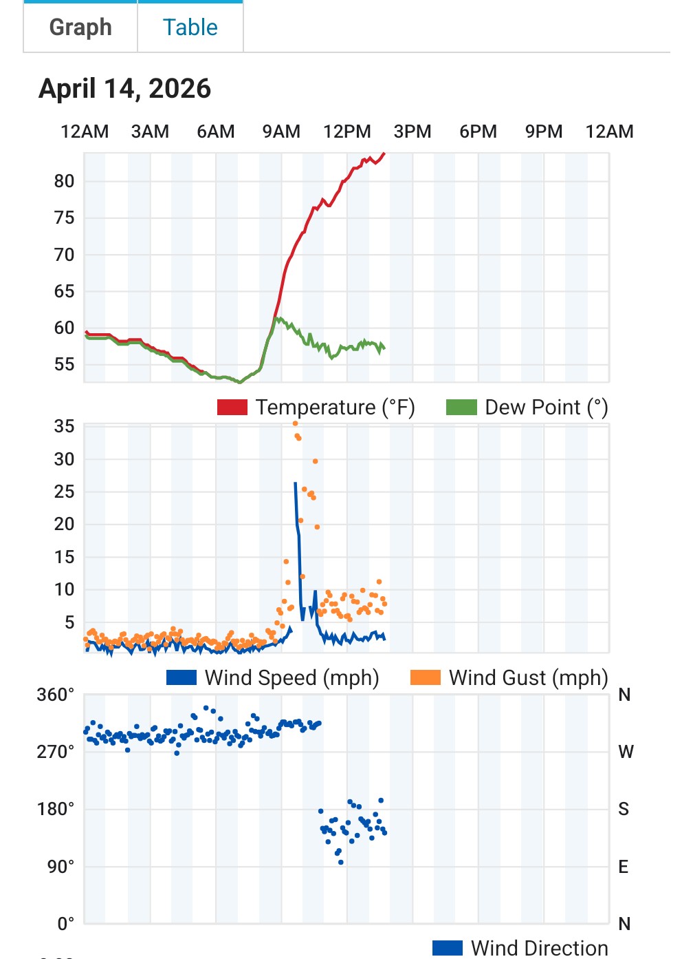
Not sure what happened just before 9am, but look at my wind and dew point. Drastic changes
-
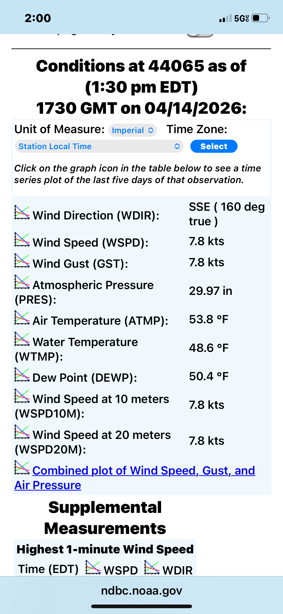
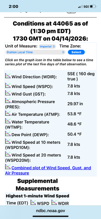
No sign of the jet yet out by the old Ambrose light obs .
-
My apologies if this belongs in Memory Lane. Both April 3rd and 4th of 1991 when I started my first route reached 87° without any leaves on the trees to cool off in the shade.
-
Well its that time of the year folks 84 here

-
Well its that time of the year folks 84 here

-
84