All Activity
- Past hour
-
Probably sleet but damn...its a ton of qpf
-

January 24-26: Miracle or Mirage Thread 2
NorthArlington101 replied to mappy's topic in Mid Atlantic
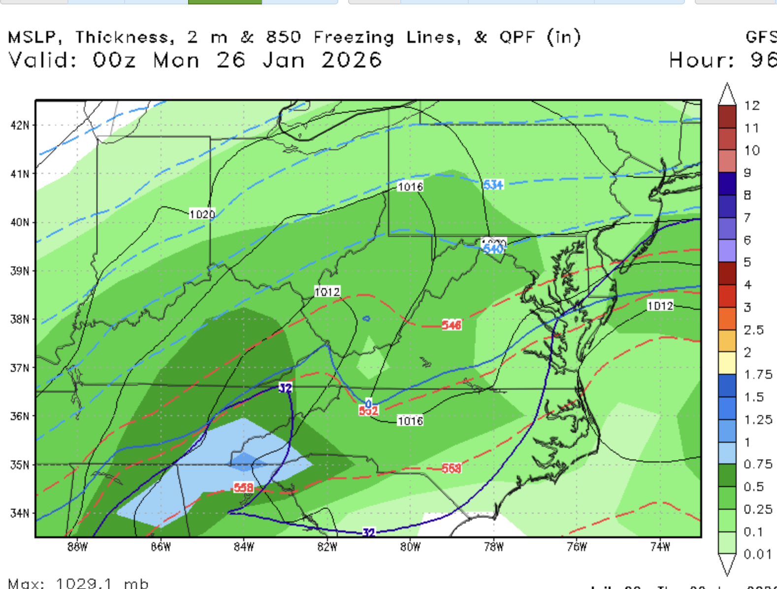
My maps show mix line tickling dc here -

Possible Record Breaking Cold + Snow Sunday 1/25 - Tuesday 1/27
SACRUS replied to TriPol's topic in New York City Metro
-
0z GFS trending towards the rest of the pack
.thumb.gif.f362b49a4a733dd007de219b58c3d33c.gif)
-

Pittsburgh/Western PA WINTER ‘25/‘26
colonel717 replied to Burghblizz's topic in Upstate New York/Pennsylvania
Up .3 that's huge. GFS joins the party. Time to go all in -
2002 redux it is.... I was really hoping for sleet
-

-
January 24-26: Miracle or Mirage Thread 2
NorthArlington101 replied to mappy's topic in Mid Atlantic
Holding at 93 -
and we lost the GFS...
-
Maybe some mire to the Southwest?
-

January 25/26 Jimbo Back Surgery Storm
StantonParkHoya replied to Jimbo!'s topic in Southeastern States
This is a very odd miller B. So much separation, it’s not even really a transfer. Almost like a double barrel miller A. Could get some backside snows if the second low transfers in a good spot. . -
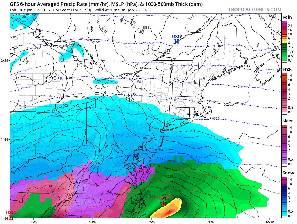
Still snow 18z Sunday in DC. Mix line looks to be near RIC.
-
15 hours of snow and transfer taking place on the coast.
-

Possible Record Breaking Cold + Snow Sunday 1/25 - Tuesday 1/27
TriPol replied to TriPol's topic in New York City Metro
Is it me or is this much more suppressed? -
Kinda meh in Boston
-
Its quite the front end thump though the second part of the storm is going to mix hard imo
-

January 25-26 Winter Storm Potential
MickeyTim6533 replied to Ralph Wiggum's topic in Philadelphia Region
hearing gfs south -
Oh man..a ton of moisture after that intial thump to our sw vs 18z...but thermals are coming for us
-
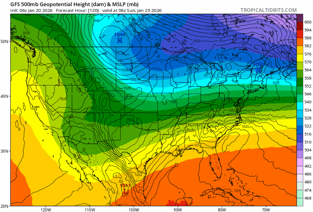
There is sooo much long wave spacing out west to get this further north. That ridge axis out west keeps inching west. It’s basically in general position where we open up inland runner risk…
-
It is indeed south of 18z through 90
-

January 25-26 Winter Storm Potential
The Iceman replied to Ralph Wiggum's topic in Philadelphia Region
Gfs only out to 90 but it looks like it’s also going to be a massive hit. I don’t know that we even see mixing issues save for the coast? -
Lock it up.

-

Possible Record Breaking Cold + Snow Sunday 1/25 - Tuesday 1/27
jdj5211 replied to TriPol's topic in New York City Metro
GFS going to be a big hit . -
Possible Record Breaking Cold + Snow Sunday 1/25 - Tuesday 1/27
SACRUS replied to TriPol's topic in New York City Metro
Snow arriving between 8 and 12 PM on Sunday -

Pittsburgh/Western PA WINTER ‘25/‘26
Mailman replied to Burghblizz's topic in Upstate New York/Pennsylvania
Yep + QPF is up.


.gif.9ed2cf3b18c9304e5a2f2731d722ea88.gif)