All Activity
- Past hour
-
So, with the lag, the -NAO/-AO should start around the Equinox (3/20)?
-
Pushing 3” in Port Jeff Station. Like a winter wonderland out there. .
-

Outta gas and Outta Time: Early March Winter Storm finale
BlizzardNole replied to Ji's topic in Mid Atlantic
I'd love for us to get lucky with this chance, then have a March at like 10F above normal. -

"Don’t do it" 2026 Blizzard obs, updates and pictures.
Greg replied to Ginx snewx's topic in New England
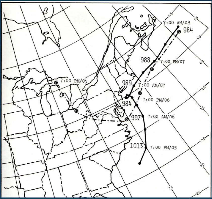
As you can see in the final snow totals in '78, the Providence area (Especially northern half) to Boston area and North Shore due to storms intensity and positioning (Track) is primarily the reason. The Blizzard of 2026 was actually more intense central pressure wise but about 70-75 miles further south than where '78 was not to mention the capture in '78 was off the coast of New Jersey not North Carolina like '26 was. Big difference in where it was captured and track inside the Benchmark. Temperatures back then was actually colder in the morning (Upper teens to Mid 20's) then rose to the upper 20's to low 30's (well inland around Worcester area low to mid 20's) with the exception of the far Southshore Cape and Islands where temps hit the mid to even upper 30's for a relatively short time as the storm made its closest pass. Storm track is crucial in storms like this one and of course in '78.
-
thanks for reminding me. I ONLY had 109" in 2015. Porked to the north and south!
-

Pittsburgh/Western PA WINTER ‘25/‘26
Burghblizz replied to Burghblizz's topic in Upstate New York/Pennsylvania
Happy beating climo snowfall today for those that celebrate. So while the Monday threat looks shaky at best, not a bad place be sitting. Either way - likely to add on before the end of the season. -
Seriously is.
-

"Don’t do it" 2026 Blizzard obs, updates and pictures.
ORH_wxman replied to Ginx snewx's topic in New England
That was part of it, but most of the snow in these tends to fall within a 18-20 hour period....the stall prob adds another half foot or something like that. Someone very lucky gets more in the stall, but usually the precip starts to get pretty banded after a time when it stalls. If you push that arc of convective snows well inland, you're gonna get crazy widespread totals....think April '97 with maybe a bit less total QPF (we wouldn't have gotten quite the juicy WCB like that one had....which fell in a lot of areas as rain) and colder of course so the net result is basically '97 with the 30"+ stuff over a larger area. But who knows for sure since we didn't see it. I agree that the current jackpot area would've gotten less if it tracked 50 miles NW, but my guess is still easily 20-30"+. -

Clipper Fires In Wednesday Feb 25 Disco/ Obs
radarman replied to Damage In Tolland's topic in New England
That low level stuff has indeed persisted and we should finish at 2" -

Clipper Fires In Wednesday Feb 25 Disco/ Obs
WxWatcher007 replied to Damage In Tolland's topic in New England
1.7” final Snow depth back up over 18” -
This is in some ways the most enjoyable snowfall this winter. The back edge looks close but it's still snowing moderately here. Good to the last drop.
-
Clipper Fires In Wednesday Feb 25 Disco/ Obs
radarman replied to Damage In Tolland's topic in New England
Ineedsnow give us a signal if torch tiger is holding you hostage -
February 25 1934: A late season cold snap produces a bitterly cold low of -46 at Big Falls. For Wednesday, February 25, 2026 1922 - The temperature at Los Angeles, CA, soared to 92 degrees to establish a record for the month of February. (David Ludlum) 1977 - Dust reduced visibilities from eastern Virginia through the southeastern states to Florida between the 24th and the 28th. The dust originated in the western Great Plains on the 22nd and 23rd, with wind gusts above 100 mph reported at Guadalupe Pass TX, at White Sands NM, in Sherman County KS, and in eastern Colorado. (The Weather Channel) 1987 - Low pressure in Nevada produced snow from the southwestern U.S. to the Dakotas. Snowfall totals in Arizona ranged up to 82 inches at Alpine. Flagstaff AZ reported 23 inches of snow in 24 hours. Other heavier snowfall totals included 20 inches at Daggett NV, 24 inches at Brian Head UT, 24 inches at Red Lodge MT, and 26 inches at Angel Fire NM. Snow at Los Alamos NM pushed their snowfall total for the winter past their previous record of 123.5 inches. (The National Weather Summary) (Storm Data) 1988 - Overnight snow squalls in the Lower Great Lakes Region buried Pulaski NY under 17 inches of snow. Sunny and mild weather prevailed across the rest of the nation. Havre MT reported a record high of 66 degrees. (The National Weather Summary) (Storm Data) 1989 - Thirteen cities in Florida reported record low temperatures for the date, including Jacksonville with a reading of 24 degrees. Severe cold in Florida claimed three lives, and resulted in 250 to 300 million dollars crop damage. Unseasonably warm weather prevailed in the central U.S. Dodge City KS reported record high of 80 degrees. (The National Weather Summary) (Storm Data) 1990 - Snow spread across the northeastern U.S. Massachusetts was blanketed with 8 to 15 inches of snow, 5 to 10 inches was reported in Rhode Island, and totals in Connecticut ranged up to 10.5 inches at New Canaan. In central New York State, snow and high winds resulted in a number of chain-reaction multiple accidents, and a total of 108 persons were injured. Snow and high winds created white-out conditions along Interstate 87 in Saratoga County NY. Subzero cold was reported from Minnesota through Michigan to northern New England. Duluth MN reported a record low of 26 degrees below zero. (The National Weather Summary) (Storm Data) 2009 - Two Alaskan communities set their all-time records for highest windspeed. St. Paul registers a wind of 91 mph, and on St George Island the wind reaches 94 mph.
-
The blizzard was the only time this winter that the GFS did so well. It’s really hard to say why this was the case. But now we are probably back to the regularly scheduled programming of the AIFS or EPS AIFS doing better. It could just be the broken clock analogy with the GFS but we may never know for sure.
-

"Don’t do it" 2026 Blizzard obs, updates and pictures.
ChangeofSeasonsWX replied to Ginx snewx's topic in New England
Yeah but regardless of temperature, 1978 stalled which was the main reason why there were those high totals over a large area. If this one tracked further inland wouldn't it have been another Feb 2013 where CT gets those totals instead of SEMA/RI? -
Still have to watch late March for a final stand
-

Clipper Fires In Wednesday Feb 25 Disco/ Obs
dryslot replied to Damage In Tolland's topic in New England
Starting to see a bit of enhancement, Radar back building over to the west in NH here which was modeled quite well, Should end up around 3" or so, My call was 2-4".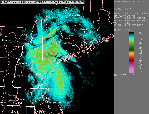
-
So I get hit with a blizzard with 20-40" storm totals, and then the NE gets hit with the same. Ma Nature n Old Man Winter hookin up on a waterbed
-
2/24 - 2/25 Clipper Obs (1 - 2" for many on forum)
Snowshack replied to Northof78's topic in New York City Metro
2.25” new in wading river. Pretty epic scenery outside for our area. Glad we can still do it. -

Clipper Fires In Wednesday Feb 25 Disco/ Obs
weatherwiz replied to Damage In Tolland's topic in New England
It's a huge weakness of the NAM where it can often struggle at initializing precipitation -
We are going to roast for a while it seems.
-

E PA/NJ/DE Winter 2025-26 Obs/Discussion
Duca892 replied to LVblizzard's topic in Philadelphia Region
Funny seeing people comment on weather forecasters/enthusiasts facebook statuses about Monday/Tuesday. Can tell people have been sharing the GFS snow maps lol -
It was the complete outlier for this past blizzard until a few days before. All hail the GFS!
-
Still snowing heavily in north suffolk. Gotta be about 3 inches out there of New snow.
-

Is we back? February discussion thread
40/70 Benchmark replied to mahk_webstah's topic in New England
I didn't really complain in 2015, when I had 115.5" and the south shore had like 135".