All Activity
- Past hour
-
I don’t know who this is but I’m not giving up hope until tonight
-
 BAM honks
 -
How can anyone write this off already? The western energy is still off shore, and has not been sampled. Hurricane hunter plane is scheduled to fly and sample this when it comes ashore tonight or tomorrow morning.
-
Id say right now a conservative 3 to 6 inches. A lot of energy flying around..we've got energy coming down from the PV and then the low. Kind of a 1 two punch possibly.
-

The Jan 31 Potential: Stormtracker Failure or 'Tracker Trouncing
wasnow215 replied to stormtracker's topic in Mid Atlantic
They'll learn- at least some haha. Always thankful for new folks. It keeps this thing going -
I don’t know what it is about Richmond and whatever’s going on with our micro-climate, but years of getting teased by storms on literally every side of us has made me thoroughly hate winter here. I hope after the threat this weekend that we can just start to move on, and all this ice melts away. The average temperature does start to go up every week beginning in February, so there’s at least that to look forward to. .
-
Congrats DT ?
-
RGEM was going to be nice too!
-
I have never seen a storm this far south and west of us on computer models just suddenly come back and hit us, which would be about 150+ mile shift west.
-
Seems that trends continued over night. Lets see what the 6z Euro has to say, but this one looks real.
-

The Jan 31 Potential: Stormtracker Failure or 'Tracker Trouncing
dailylurker replied to stormtracker's topic in Mid Atlantic
Our last snow was modeled to hit VA at this lead. It ended up 400 miles north. Hell.. by tomorrow this could be congrats Hershey Park (why the hell did i us Hershey Park). We're still in the game. -

Possible coastal storm centered on Feb 1 2026.
Roger Smith replied to Typhoon Tip's topic in New England
Greenland Air Force? -

The “I bring the mojo” Jan 30-Feb 1 potential winter storm
WXNewton replied to lilj4425's topic in Southeastern States
GEFS becoming pretty consistent of the overall totals and area to be affected. Looks like major jumps, have turned into wobbles at this point. I would expect minor shifts each run, with the overall footprint starting to lock in..gif.3ba9f1340bb8dd58f0c78f8410743e50.gif)
-

E PA/NJ/DE Winter 2025-26 Obs/Discussion
Ralph Wiggum replied to LVblizzard's topic in Philadelphia Region
75% chance skirts part of our subforum s and e, 15% chance entire region missed completely, 10% chance major hit Philly and burbs. Thats the way I see it attm. Need some major changes at 12z and 18z. -
Too early to write it off but trend isnt good.
-
If February is in fact another colder than normal month, we will be at the door of a place we haven’t been in with a La Niña winter in over 30 years (1995-1996). In order to actually tie that winter with 5 months (November-March) in a row of below normal cold, March will also have to another below normal cold month, still way too early to determine March, but February will at least be off to a very good start…..
-
The Jan 31 Potential: Stormtracker Failure or 'Tracker Trouncing
Roger Smith replied to stormtracker's topic in Mid Atlantic
Pretty rare to see a southwest moving upper cold core and so you have to wonder how skilled would any models be in resolving future motions of the resultant energy? My subjective guess is that they would have little or no skill, so therefore the only part of any model run we can trust at this stage is out to 96-102h, what happens after that is purely conjecture from low-skill models (all of them in this case). I believe in reality you have a 50-50 shot at a significant snowstorm in DC and BAL from this foundation. NYC is probably closer to 25%, then it's back up towards 50-50 in New England (70% Cape Cod). I think it's 80 to 90 per cent locked in that s.e. VA and some parts of NC see large snowfalls, there is not going to be an inland complicating primary with this. -
 Those are both 0z you posted.
 -

The Jan 31 Potential: Stormtracker Failure or 'Tracker Trouncing
mitchnick replied to stormtracker's topic in Mid Atlantic
That's snow depth measuring what's already on the ground that isn't melting. -

Central PA Winter 25/26 Discussion and Obs
Caveman replied to MAG5035's topic in Upstate New York/Pennsylvania
This is from the CIPS website...kinda fun to peruse... https://www.eas.slu.edu/CIPS/ANALOG/analog.php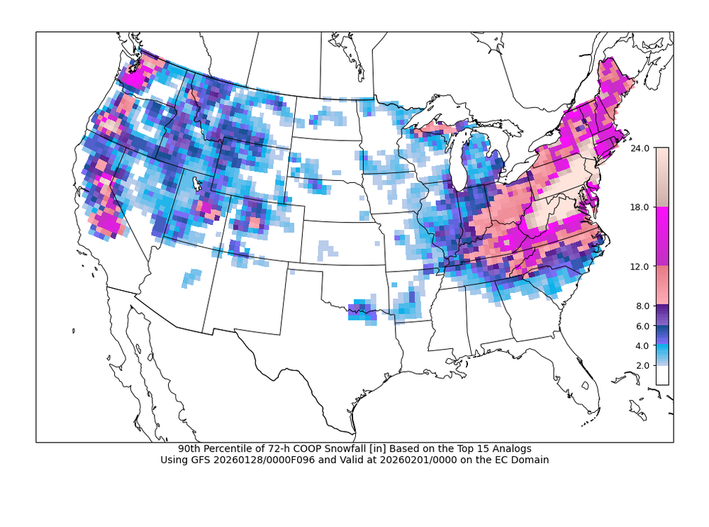
-

The Jan 31 Potential: Stormtracker Failure or 'Tracker Trouncing
Cary replied to stormtracker's topic in Mid Atlantic
Spit my soda at this -

Richmond Metro/Hampton Roads Area Discussion
RVASnowLover replied to RIC Airport's topic in Mid Atlantic
GFS basically holds at 6z. It’s either going to fail miserably and cave at some point or be right. IMO this is a SEVA/ENC special. Maybe we get a glancing blow in RIC -

The Jan 31 Potential: Stormtracker Failure or 'Tracker Trouncing
Weather Will replied to stormtracker's topic in Mid Atlantic
0Z CFS is good; no idea if it is ever right.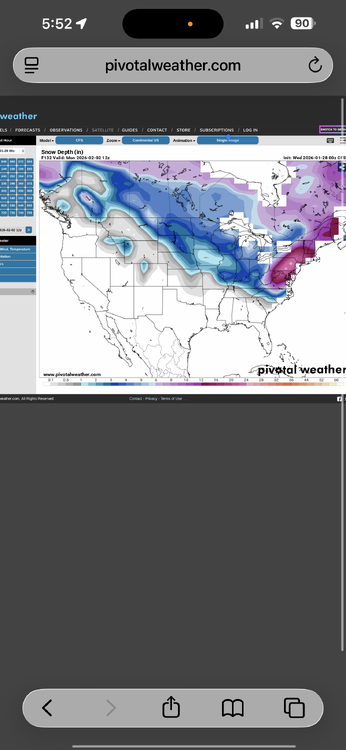
-

The Jan 31 Potential: Stormtracker Failure or 'Tracker Trouncing
mappy replied to stormtracker's topic in Mid Atlantic
I don’t know half the people posting ITT. So many new folks. So much banter. -

The Jan 31 Potential: Stormtracker Failure or 'Tracker Trouncing
stormtracker replied to stormtracker's topic in Mid Atlantic
Yeah, with heavy snow 50 miles to the south on models that never trend north, it’s time to stop tracking. See you Monday. Gonna miss your always insightful posts.


