All Activity
- Past hour
-
Fingers crossed!
-
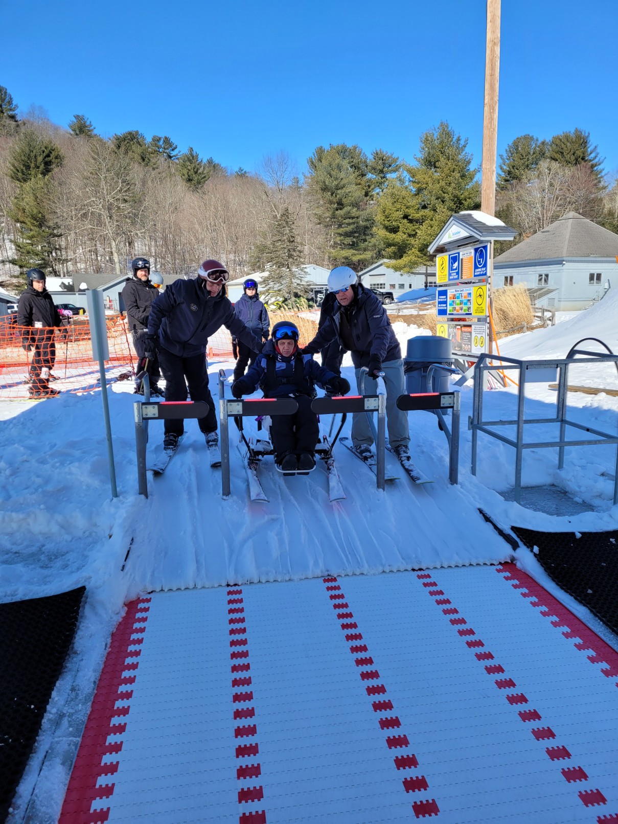
No I can't balance my hands for turning. My arms are too week. The sled has a steering rod and the ski's angle to let me turn. I pull back on the rod to brake. I ski tethered to my instructor. The sled is locked down and spring loaded and pops up for getting on the chairlift.

-
No that was as close to a porking as you can imagine. The end of my street literally had more than I did about 400 yards away. Another mile west had 2-3”. Imagine walking to a friends house down the street leaving your bare yard to their white Christmas. It was a mind f*ck.
-
Looks at that. A back end mini death band setting up over MD 26 in Carroll and NW Baltimore counties.
-

December 2025 Short/Medium Range Forecast Thread
Carvers Gap replied to John1122's topic in Tennessee Valley
I think the next "system" will be Sunday night. The 12k NAM has it as does the RGEM. it is coming in at night. If the NAM is correct, that could be minor to moderate upslope for the Plateau and maybe the Apps. The MJO is a "choose your own adventure" this morning at CPC. It has yet to loop back around. But....the GFS and Euro now show it stalling in 8 - and I am still not sure that actually happens! If it actually stalls in 8 for a long period of time(and it is already halfway across 8), that would leave the door open for very cold temps. I almost kind of wonder if the CFS has it right. It trucks across the cold phases, rolls through the COD to 6, and then goes back through the cold phases again. That looks an awful lot like those CHI graphics Jax recently posted. Strong 1-2, strong Maritime, continues to dateline. I do think we have a cold shot coming mid month...we'll see if I am right! LOL. -
Outside putting up Christmas lights and occasionally seeing the tiniest of snow flake float by. Overachiever!!
-
I'd say about 1.5" here in 20910; still snowing.
-
If DCA got an inch this early in the season how does the rest of the winter usually bode for them?
-
General odds of a moderate accumulating snow, at least should increase, the next 15 to 25 days with the - SOI dive and a re-set of the MJO.
-
I think he's in Virginia
-

December 2025 regional war/obs/disco thread
SouthCoastMA replied to Torch Tiger's topic in New England
Do you have a top floor? Maybe you couldve seen it from a distance -

December 2025 regional war/obs/disco thread
Kitz Craver replied to Torch Tiger's topic in New England
Up and In FTW -
3.0 inches north side of Waynesboro. Got my driveway plowed out. Still flurries falling. 28 degrees.
-
2005 Dec 5
-
At least BDL got 2.4”
-
That one and the Blizzard of 1978 were the two.
-
(002).thumb.png.6e3d9d46bca5fe41aab7a74871dd8af8.png)
Central PA Fall Discussions and Obs
ChescoWx replied to ChescoWx's topic in Upstate New York/Pennsylvania
Some of you might not remember this but December 5th has been one of the snowier days in our December history below are the years it snowed here in Chester County and how much snow we ended up with in that winter season.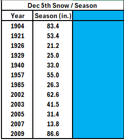
-

December 2025 regional war/obs/disco thread
Sey-Mour Snow replied to Torch Tiger's topic in New England
-
E PA/NJ/DE Winter 2025-26 Obs/Discussion
ChescoWx replied to LVblizzard's topic in Philadelphia Region
Some of you might not remember this but December 5th has been one of the snowier days in our December history below are the years it snowed here in Chester County and how much snow we ended up with in that winter season.
-
@WxUSAF spotter in Sykesville, Carroll County just reported M0.5" snow. I think you got close to an inch.
-

Central PA Fall Discussions and Obs
Jns2183 replied to ChescoWx's topic in Upstate New York/Pennsylvania
I'd rather rain than dry. Nothing is as bad as dry Sent from my SM-S731U using Tapatalk -
About 1” in Damascus
-

December 2025 regional war/obs/disco thread
weatherwiz replied to Torch Tiger's topic in New England
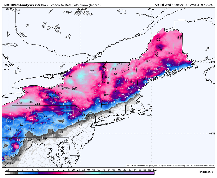
Yup. There is nothing wrong with several 3-5" type ordeals. And we see plenty of potential for that on guidance. If anyone is just looking for 8-12"+ storms all the type...they're going to be disappointed 99% of the time. I believe BDL is already at average or even slightly above for the season...and its only Dec 5. I don't remember off-hand what BDL's average Dec snow is but I don't think its any more than 5 or 6". Another one of these 2-3" storms for them in the next 26 days and it was an average month. -
December 2025 regional war/obs/disco thread
Sey-Mour Snow replied to Torch Tiger's topic in New England
The M woulda been worse -
I can't disagree with you there. But if we could push the trough west a bit and allow for just a hint of offshore ridging (off the east coast) like the MJO map shows, it would slow the storm track down and give a better chance of snow for many. So impressively cold for some yes, but we have got to get some moisture with an improved storm track or it hardly matters.