All Activity
- Past hour
-
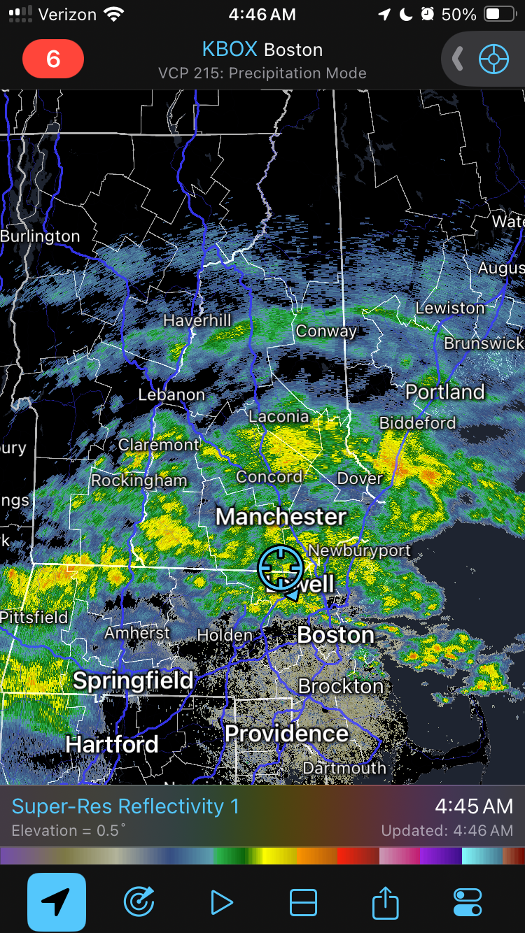
57° rain should be here soon. Hopefully it moves quickly.
-
Steined for once. Let’s clear this shit out.
-
How many apple martinis?
-
1200 dcape and 100/65 .. good wind threat. You were drunk
-
Columbia: Friday 6/13/25 0.09” — heaviest rains were to my south
-
0.18” here pretty pathetic for being under a flood warning
-
 Lekian4 joined the community
 -
Flood Watch National Weather Service State College PA 241 AM EDT Sat Jun 14 2025 PAZ010>012-017>019-045-046-049>053-142000- /O.NEW.KCTP.FA.A.0012.250614T0641Z-250614T2000Z/ /00000.0.ER.000000T0000Z.000000T0000Z.000000T0000Z.OO/ Elk-Cameron-Northern Clinton-Clearfield-Northern Centre-Southern Centre-Southern Clinton-Southern Lycoming-Union-Snyder-Montour- Northumberland-Columbia- Including the cities of Sunbury, Renovo, Ridgway, St. Marys, DuBois, Lewisburg, Bloomsburg, Philipsburg, Williamsport, Lock Haven, Clearfield, Berwick, Selinsgrove, Shamokin, Danville, State College, and Emporium 241 AM EDT Sat Jun 14 2025 ...FLOOD WATCH IN EFFECT THROUGH THIS AFTERNOON... * WHAT...Flash flooding caused by excessive rainfall is possible. * WHERE...A portion of central Pennsylvania, including the following areas, Cameron, Clearfield, Columbia, Elk, Montour, Northern Centre, Northern Clinton, Northumberland, Snyder, Southern Centre, Southern Clinton, Southern Lycoming and Union. * WHEN...Through this afternoon. * IMPACTS...Excessive runoff may result in flooding of rivers, creeks, streams, and other low-lying and flood-prone locations. Flooding may occur in poor drainage and urban areas. * ADDITIONAL DETAILS... - A several hour period of moderate to heavy rainfall and possible embedded thunderstorms this morning could produce widespread rainfall amounts of 1 to 2 inches in the Watch area with local amounts exceeding 3 inches. Rainfall rates of 1 to 2 inches per hour could produce flash flooding. - http://www.weather.gov/safety/flood PRECAUTIONARY/PREPAREDNESS ACTIONS... You should monitor later forecasts and be prepared to take action should Flash Flood Warnings be issued.
-
I'm at 0.00
- Today
-
Not even narrow. Is it too much to ask for a dry fucking Saturday morning? Where’s the Stein talked about?
-
Flood Watch National Weather Service Baltimore MD/Washington DC 212 AM EDT Sat Jun 14 2025 DCZ001-MDZ013-016>018-504-VAZ025>031-036>040-050-051-053>057-501-502- 505>508-526-527-141415- /O.NEW.KLWX.FA.A.0012.250614T1800Z-250615T0300Z/ /00000.0.ER.000000T0000Z.000000T0000Z.000000T0000Z.OO/ District of Columbia-Prince Georges-Charles-St. Marys-Calvert- Central and Southeast Montgomery-Augusta-Rockingham-Shenandoah- Frederick VA-Page-Warren-Clarke-Nelson-Albemarle-Greene-Madison- Rappahannock-Orange-Culpeper-Fairfax-Arlington/Falls Church/Alexandria-Stafford-Spotsylvania-King George-Northern Fauquier-Southern Fauquier-Western Loudoun-Eastern Loudoun- Northern Virginia Blue Ridge-Central Virginia Blue Ridge- Northwest Prince William-Central and Southeast Prince William/Manassas/Manassas Park- 212 AM EDT Sat Jun 14 2025 ...FLOOD WATCH IN EFFECT FROM 2 PM EDT THIS AFTERNOON THROUGH THIS EVENING... * WHAT...Flooding caused by excessive rainfall is possible. * WHERE...Portions of DC, including the following , District of Columbia, Maryland, including the following areas, Calvert, Central and Southeast Montgomery, Charles, Prince Georges and St. Marys, and Virginia, including the following areas, Albemarle, Arlington/Falls Church/Alexandria, Augusta, Central Virginia Blue Ridge, Central and Southeast Prince William/Manassas/Manassas Park, Clarke, Culpeper, Eastern Loudoun, Fairfax, Frederick VA, Greene, King George, Madison, Nelson, Northern Fauquier, Northern Virginia Blue Ridge, Northwest Prince William, Orange, Page, Rappahannock, Rockingham, Shenandoah, Southern Fauquier, Spotsylvania, Stafford, Warren and Western Loudoun. * WHEN...From 2 PM EDT this afternoon through this evening. * IMPACTS...Excessive runoff may result in flooding of rivers, creeks, streams, and other low-lying and flood-prone locations. Creeks and streams may rise out of their banks. Flooding may occur in poor drainage and urban areas. * ADDITIONAL DETAILS... - Showers and thunderstorms will increase in coverage through this afternoon and evening. Some thunderstorms will contain heavy rainfall, with rainfall amounts around 1 to 3 inches possible within an hour or two. Storms may also train over the same areas, causing the possibility for locally higher amounts around to 5 inches of rain within a few hours. Heavy rainfall in a short period of time combining with already saturated soils means that creeks and streams may rapidly rise out of their banks along with the potential for flash flooding in urban areas.
-

Mountain West Discussion
gallopinggertie replied to mayjawintastawm's topic in Central/Western States
NWS Fairbanks has just issued its first ever heat advisories. The temperatures are not that unusual for interior Alaska (in the mid to upper 80’s), but the duration of the heatwave will be at least a week. They’re trying to prepare people better for heat up there than they have in the past, which is smart seeing as houses in alaska lack ac and they can expect more and more of these heat events in the coming decades. -
You're thinking of 2014, 2013 was very much like the previous summers .... we usually group 2010-2013 together, it was the last time JFK hit 100. It was also the last time we had what I call a super heat wave..... 7+ days of 90+
-
yep hit 80 here around noon
-
At least something is loaded.
-
1.22 here.... Most of my weather data from 07 [ when I moved to northern Waynesboro from western Albemarle ] to Sept 2020 is gone - so I dont know how many , but this has got to be one of the very few times since moving here that 2 thunderstorms within a week dropped over a inch. We rarely get a half inch in my backyard from any single tstorm.. Tropical rain we do well - thunderstorm rain we do not.. Much different this year than the past 3 years by the middle of June...
-
81 here today
-
Stormy since 5 p.m. with slow moving cells parked near the escarpment. We have had 1.22 today and another cell is moving towards us.
-
Picked up.45" early this afternoon and another .43" this evening. My monthly total is not up to 3.10".
-
Sounding blows he drunk.
-
lol this sounding is nothing special at all. Even assuming it's overmixed in the boundary layer you've got CAPE that's not impressive with meh mid-level rates. You also have 0-6km shear on the order of 25 knots or so which is not sufficient for organization/supercells. Absolutely nothing like 6/20/95 or any of our more memorable events.
-
Looking like 4+ inches of rain on the way over the next 10 days or so. May end up pushing double digit monthly rainfall totals for June if the pattern persists through late month. I'll be out in the pacific northwest all next week, so you can count on some quality storm action around here then lol.
-
It looks like order has been restored in the world. Lol. Next to nothing here. Drove through quite a storm south of Staunton this evening.
-
Man what a ball game !
-
Was down picking the older Ms J. up at Dulles but watching the weather. Saw a storm headed right for our house in Frederick. Just got home and checked the gauge. Picked up 1.16” out of just that one cell.
-
0.05”. Congrats NoVA on the 5-10”