All Activity
- Past hour
-
I found one awhile back, but I forgot to bookmark it, so I don't remember what site it was from.
-
Me neither, hence my earlier post.
-
I just missed this one since I flew out in the early afternoon. It was horrendous for the northern/eastern parts of the city especially. Glass broke at the Capitol, wind damage at the airport and pictures of huge hail drifts a few miles NE of downtown. Apparently it was also a microburst over the city with over 80mph wind. Brief attempt at a tornado near downtown that thankfully didn’t complete. When I lived there I saw a couple that were fairly bad but not like this especially with the hail. People are saying this was one of the worst to hit the city in quite some time. If the storms on Monday fired a little further east before bowing out those would’ve been a lot worse in the city.
-
Yay. Local farmers are already complaining about powder molds and stunted growth with some vegetables. If I was growing commercially I would definitely want greenhouses or hoop houses.
-
you need a dehumidifier
-
That's one jackpot no one wants to be in after a wet 3-4 weeks
-
Looks like you'll be in the jackpot with this system.
-
Someone in NW CT to western MA and SW NH is going to get inches of rain.
-

Central PA Spring 2025
Itstrainingtime replied to canderson's topic in Upstate New York/Pennsylvania
Interesting - do you have any idea when it rained? Nothing measurable fell here. I've often wondered this but never asked, is there a radar history that is available to review over the past 24 hours or so? I'd love to see what came through overnight...when, how large of a cell, etc. -
A shame that we’re going to back into a below normal month after such a warm start. Really thought we’d get 23 out of 24 for the 2 year period starting July 2023.
-
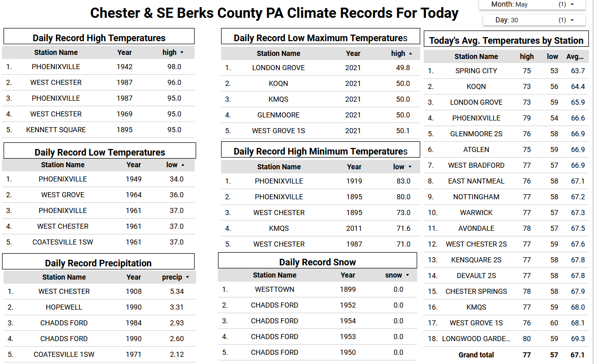
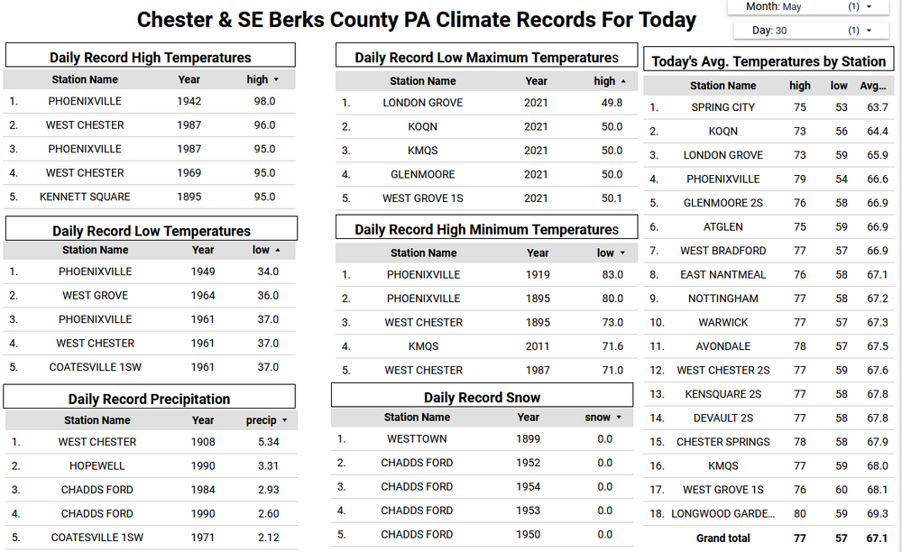
Flood Watch was issued earlier. I see some areas are now slightly below normal for the month after this cool rainy period.
-
yep my electric bill for May was very low.
-
The positives are low utility costs. I’ll enjoy it as long as possible.
-
I knew it was going to rain but didn’t expect such big forecasts.
-
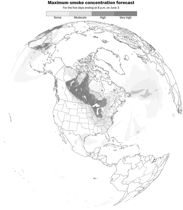
Well, here we go again, the Northern jet directs a huge plume of smoke from the vast forest fires in Manitoba, Canada Southward into the US. According to the latest modeling the thickest smoke will arrive near DC., NE MD and DE areas between 1:00 PM and 5:00 PM tomorrow afternoon.
-

E PA/NJ/DE Spring 2025 Obs/Discussion
FPizz replied to PhiEaglesfan712's topic in Philadelphia Region
Down to -0.6 for the month after a pretty ++ start -
12z HRRR has shifted the heaviest stuff to the north of the M/D line.
-
I'm on board for today... think tornado potential is decent up to the MD/PA border.
- 783 replies
-
- 3
-

-

-
- severe
- thunderstorms
- (and 2 more)
-

2025 Spring/Summer Mountain Thread
Buckethead replied to Maggie Valley Steve's topic in Southeastern States
Tornado warning south of Knoxville. Sent from my SM-S908U using Tapatalk -
Some sun today with temperatures finally near normal in the mid 70's for the end of May. Heavy Rain tonight into tomorrow with as much as 2 to 3 inches possible in some locations. The wet and chilly pattern looks to finally break starting Sunday and into next week with temperatures by Wednesday in the low 80's.

-

E PA/NJ/DE Spring 2025 Obs/Discussion
ChescoWx replied to PhiEaglesfan712's topic in Philadelphia Region
Some sun today with temperatures finally near normal in the mid 70's for the end of May. Heavy Rain tonight into tomorrow with as much as 2 to 3 inches possible in some locations. The wet and chilly pattern looks to finally break starting Sunday and into next week with temperatures by Wednesday in the low 80's.
-
Looking for some interesting barometer readings tomorrow in the NE. Coastal storms have been going nuts.
-
Clearing line moving East quickly
-
SPC upgraded to Enhanced for NC/SC and GA for wind. They are waiting to see if our region needs to be upgraded at the next update.
- 783 replies
-
- 1
-
-
- severe
- thunderstorms
- (and 2 more)
- Today
-
I’m far from confident in this, as there will probably be a narrow corridor of big rainfall models that the models are struggling to place, but there seems to be a trend to place the heavy rain axis more up into northern MD and southern PA. This would reduce the flood threat in and around DC, but it would increase the severe threat.


.thumb.png.4150b06c63a21f61052e47a612bf1818.png)