All Activity
- Past hour
-

2026 Mid-Atlantic Severe Storm General Discussion
Eskimo Joe replied to Kmlwx's topic in Mid Atlantic
D2 ENH is the new D2 MOD in these parts. -
Nothing new....we probably will really have no idea how it will play out locally until 10am tomorrow or later
-

2026 Severe Wx - General Thread
SchaumburgStormer replied to largetornado's topic in Lakes/Ohio Valley
Yup, not expecting much -
Winds switching more W. Temps rising over the last hr from upper 70's to upper 80's. 89/64 now. Low dew feels good.
-
NAM Hrrr and gfs pretty uninspiring for back here
-
2026 Mid-Atlantic Severe Storm General Discussion
Eskimo Joe replied to Kmlwx's topic in Mid Atlantic
12z NAM twins look like complete garbage. Not even MRGL risk worthy. Ooof. -
 CAPE changed their profile photo
 -
Better banding features especially in eastern quad on radar but center still dealing with serious dry air. Recon confirms with very light winds a good distance from center. Not far off from TS but not very well organized at all. NE shear is very evident and dry air intrusion will certainly limit this thing. Not sure the environment gets better even if it misses land and went south of Louisiana some models actually show shear increasing later on
-
The timing is still very uncertain. Hopefully, there will be greater clarity during the 18z and 0z runs.
-
It's true and also Raleigh's drought was probably the most anomalous in the state before recent rains. 1986 was the lowest rainfall year through this date for both GSO and RAH. But for RAH that total was 14.13, while GSO managed only 8.6" YTD in 1986. So while GSO is running ~3" behind RAH YTD this year, we are actually running ahead of the 1986 record by a wider margin (wetter than), when compared with RAH which would catch 1986 with one good dry spell
-
Models all over with regards to timing. Some have heavy rain tomorrow morning, tomorrow night or Wednesday
- Today
-
Just had the first precip from a band storm here in Fort Walton Beach. It lasted literally a minute but, the rain rate was extreme. .
-
I think the key here is Wake/Durham/franklin counties probably had the wettest month after being left out on everything rest of the year. Does alter one’s perception when you’re under repeated rains vs someone a county or less away not seeing them
-
Day 2 Convective Outlook NWS Storm Prediction Center Norman OK 1230 PM CDT Mon Jul 20 2026 Valid 211200Z - 221200Z ...THERE IS AN ENHANCED RISK OF SEVERE THUNDERSTORMS ACROSS PORTIONS OF THE UPPER OHIO VALLEY INTO THE MID-ATLANTIC... ...SUMMARY... Numerous severe thunderstorms are expected across a broad region from the Ohio Valley into the Mid-Atlantic and Northeast on Tuesday. All severe hazards are possible, but swaths of damaging wind gusts should be the primary severe risk Tuesday afternoon into the nighttime hours. ...Synopsis... High amplitude ridging will build across the western US with continued progressive troughing across the east on Tuesday. Multiple short-wave impulses will rotate through the eastern US trough, with a belt of enhanced northwesterly flow traversing the Midwest into the Ohio Valley. At the surface, a cold front will shift south and east through the period, with a surface low across southern Ontario/Quebec. A pre-frontal surface trough will also be in place across western/central NY into the Mid-Atlantic vicinity. Widely scattered thunderstorm activity is expected through the period. ...Mid-Atlantic and Northeast... Thunderstorm activity is expected to increase along the pre-frontal trough from western/central New York into the Northeast/Mid-Atlantic late Tuesday morning into the afternoon. Though there may be potential for early morning cloud cover, it does appear that sufficient heating/moistening will occur for at least moderate instability to develop across the region through the afternoon. Mid-level flow will increase through the day along with forcing for ascent. It appears widely scattered thunderstorm activity with several clusters/embedded supercells will be ongoing by the afternoon. Highest confidence in transient embedded supercell modes would be closer to the surface low and near the front across western NY into eastern PA. Here, there may be potential for both damaging wind, large hail, and perhaps a couple of tornadoes. Guidance suggests the best signal for damaging wind will be across the Mid-Atlantic, where several damaging clusters could occur. As such, the Enhanced was expanded eastward into portions of the Mid-Atlantic. ...Ohio Valley... Evolution of overnight convection will play a large role in development/maintenance of thunderstorm activity across the Ohio Valley Tuesday. It appears that remnant convection will be ongoing at the start of the period near/just ahead of the surface front across northern Kentucky/southern Indiana/Ohio. This will likely re-intensify and continue to expand south and east during the morning as daytime heating begins. Strong daytime heating and moist profiles should support moderate to strong instability developing though the afternoon. Storm mode appears to be generally linear, with the greatest threat being for damaging wind given more linear forcing/initially boundary parallel shear along residual southward moving outflow. As such, the primary hazard will be damaging wind. Additional thunderstorm development is likely along and ahead of the front through the afternoon with increasing forcing for ascent with approaching shortwaves. Strong deep layer shear may become more boundary perpendicular supporting a supercell or two as the front sags south, with potential for large hail and perhaps a tornado. Confidence in this scenario is on the lower end and the primary hazard is expected to be a secondary wave of damaging wind potential. Should storms be able to cluster and establish a more organized cold pool, potential for some corridor of significant wind may be possible. Overall, no significant wind areas were included given low confidence in exact morning storm evolution and concerns over generally poor lapse rates. ..Thornton.. 07/20/2026
-
We’ve reached the stage where if you look at the sky funny it will rain on you
-
- 1,188 replies
-
- 1
-

-
- severe
- thunderstorms
- (and 7 more)
-
CHAMBER OF COMMERCE DAY
-

2026 Mid-Atlantic Severe Storm General Discussion
batmanbrad replied to Kmlwx's topic in Mid Atlantic
and in the 1:30PM update the ENH was expanded eastward, now covers all or nearly all of our area. -
July totals for RAH, feast or famine. Hoping for an area-wide soaking from Bertha's left behind moisture GSO .83 Raleigh 5.25 Chapel hill 3.15 Fayetteville 1.05 Asheboro .64 Rocky mount 1.4 Goldsboro .83 Wilson 3.63
-
A lot of sw to ne flow, which I’ve noticed, tends to work out poorly for me. The South Mts either block things or the cells anchor in that region. I wonder if you’re getting the ol Mt Mitchell block.
-
Second day in a row I’ve had a heavy shower blow up right overhead before it even showed on radar
-
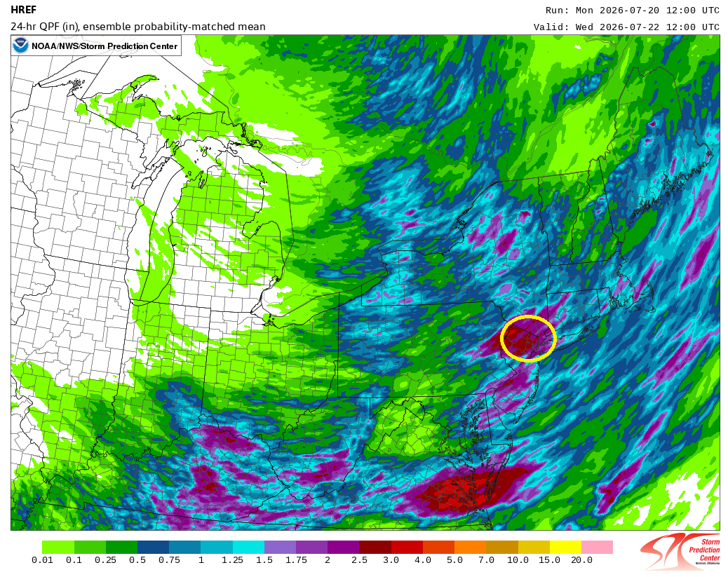
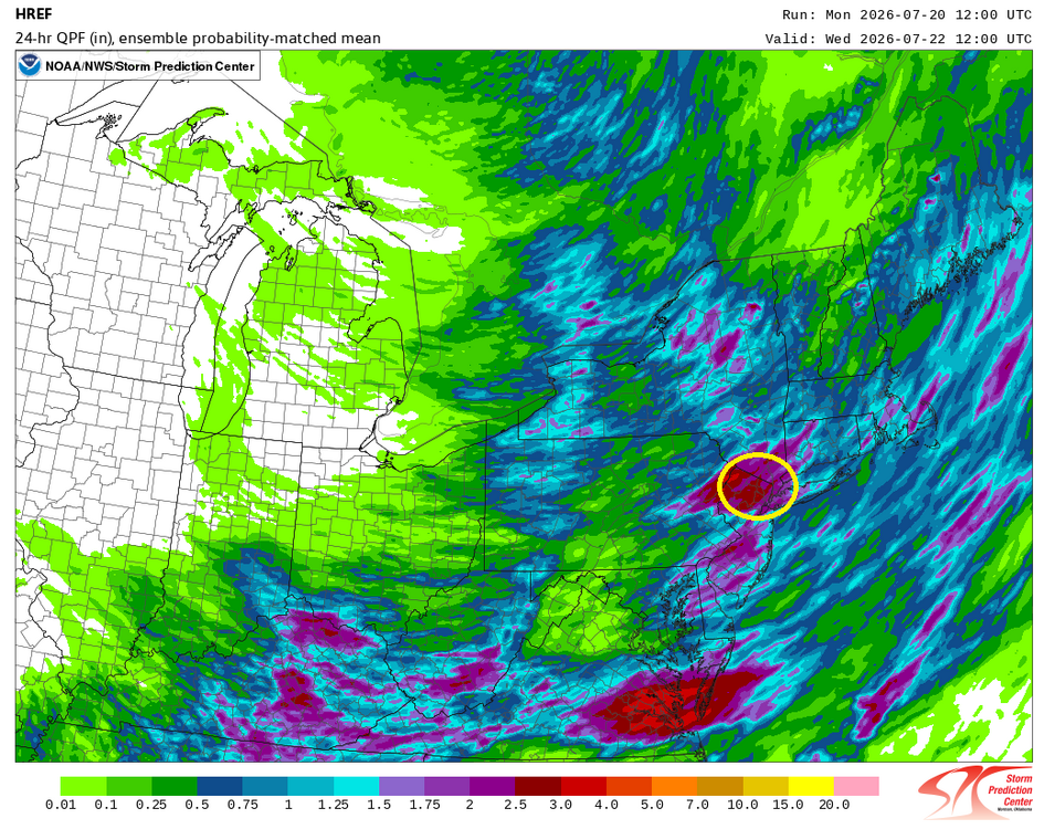
The latest HREF is showing the potential for 1.50"-3.00" of rain across the New York City Metro Area. If this holds through the 0z cycle, it wouldn't surprise me if flood watches are put in place for Tuesday into Wednesday.
-
81 / 48 just a superb out day
-
Bottomed out at 59.7 here. Up to 78 now, beautiful day
-
 So what does ACATT mean to this social media depot ?