All Activity
- Past hour
-

July 2025 Discussion-OBS - seasonable summer variability
donsutherland1 replied to wdrag's topic in New York City Metro
Central Park (31 days) has tied its July record for most 80F (26.7C) or above days. In addition, July 2025 is the second consecutive July with 31 such days, which sets a new record for most consecutive years. The only other years were 1944, 2022 and 2024. -
Take a look at this YouTube vid from that South American ski resort.
-
July 2025 Discussion-OBS - seasonable summer variability
donsutherland1 replied to wdrag's topic in New York City Metro
JFK Airport (31 days) and Newark (31 days) have tied their July records for most 80F (26.7C) or above days. JFK Airport (2 consecutive years) and Newark (4 consecutive years) have their longest streaks of 31 80F (26.7C) or above July days. Neither site had ever had 2 consecutive such years before their current streaks. - Today
-
The UKMET is back to having a TD form on the 0Z. But unlike yesterday’s 0Z, which developed the current central MDR wave that was moving NNW to threaten the SE US, this one forms on an old front just off the SE US coast. After forming, it crawls NNE to just offshore the Mid-Atlantic coast remaining as a TD: NEW TROPICAL CYCLONE FORECAST TO DEVELOP AFTER 90 HOURS FORECAST POSITION AT T+ 90 : 32.0N 75.3W LEAD CENTRAL MAXIMUM WIND VERIFYING TIME TIME POSITION PRESSURE (MB) SPEED (KNOTS) -------------- ---- -------- ------------- ------------- 0000UTC 04.08.2025 96 31.4N 75.7W 1010 29 1200UTC 04.08.2025 108 32.1N 74.8W 1012 25 0000UTC 05.08.2025 120 32.1N 75.0W 1013 25 1200UTC 05.08.2025 132 33.1N 73.9W 1015 23 0000UTC 06.08.2025 144 34.3N 73.9W 1015 23 1200UTC 06.08.2025 156 35.7N 73.6W 1014 30 0000UTC 07.08.2025 168 37.6N 73.0W 1012 28 *Edit: 0Z Euro is a bit similar to 0Z UKMET but with just a very weak sfc low rather than a TD. It similarly goes up the US E coast just offshore and the toward Cape Cod and Maine.
-

July 2025 Obs/Disco ... possible historic month for heat
CT Rain replied to Typhoon Tip's topic in New England
Yeah BOX sent that one out -
with 2" PW values? That's pretty tough to do. Our path to a SLGT is yesterday's 12Z HRRR or NAM Nest, with a semi-organized line arriving just after peak heating. The majority of the solutions this evening, which break out convection way early and not very organized, would likely only justify a MRGL for a few wet microburst events early in the event before it becomes a heavy rain situation.
-
Dry all day here. Heard (still hearing) thunder since early afternoon. Amazing how localized showers can be this time of year.
-

July 2025 Obs/Disco ... possible historic month for heat
dendrite replied to Typhoon Tip's topic in New England
I saw the 32C 5 min obs, but not an official 90° yet unless BOX posted something. -

2025 Atlantic Hurricane Season
Boston Bulldog replied to BarryStantonGBP's topic in Tropical Headquarters
Amazing news. SSMIS and similar polar-orbiting scans aren’t perfect, but they are the best Hurricane inner core analysis tool outside of in-situ observations and radar. -
 Supposed to play Friday afternoon. Probably gonna be one of those days where it's reasonable out by late morning but it's moot because the course never opened due to overnight rain.
 -

July 2025 Obs/Disco ... possible historic month for heat
Torch Tiger replied to Typhoon Tip's topic in New England
that is wild -
It was doing the same here but lately the thunderstorms have been hitting daily.
-
July 2025 Obs/Disco ... possible historic month for heat
CT Rain replied to Typhoon Tip's topic in New England
90F at 9:50p lol -

July 2025 Obs/Disco ... possible historic month for heat
Brewbeer replied to Typhoon Tip's topic in New England
Also a fan of these conditions, especially skiing, keeps the crowds in the lodge and the conditions crisp. You can dress for the cold; can't do that for heat/humidity -
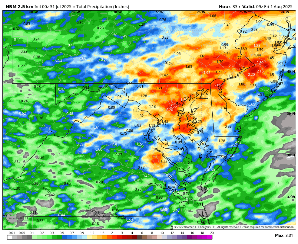
WB 0Z NBM for tomorrow. I hope it is even half correct....

-
July 2025 Obs/Disco ... possible historic month for heat
dendrite replied to Typhoon Tip's topic in New England
Freakin Logan. lol Not sure if they snuck in 90° but they got 89° -
 Picked up .22 here this evening.
 -
Should finish rather close to the hottest July and any month on record for Virginia, West Virginia, and Maryland. Looking at the current statewide numbers, I'm thinking 3rd place, perhaps even 2nd in Maryland. Maybe somewhat surprising looking only at the urban numbers, but a lot of rural and high elevation locations have cooked this month.
-
Really been short changed irt Rainfall here at my home east of Jonesville. Under 4 inches for the Month so far. Average is about 5.25". Just continues to develop all around us . It's as if we have a mini dome around here.
-
 Have a golf outing tomorrow, shot gun start at 1 pm. Will probably be wet
 -
Though 8/4-10 dropped due to no support likely partially related to little support for the current MDR AEW, today’s Euro Weeklies are slightly more ominous than yesterday’s for August’s ACE as a whole: % of 2005-24 averages: 8/4-10: 80% (slightly lower than yest.) 8/11-17: 190% (slightly higher than yest.) 8/18-24: 210% (much higher than yest.) 8/25-31: 110% (same as yest.) Taken as a whole, these probably imply a prog of ~38 ACE for next month fwiw. Please don’t shoot the innocent messenger!

-
Several evening hi-res runs now initiate storms in the area by early afternoon and possibly even a bit earlier.
-

July 2025 Obs/Disco ... possible historic month for heat
CoastalWx replied to Typhoon Tip's topic in New England
That did well here on 7/10. -
Interesting that some of the evening CAM guidance initiates convection in the area MUCH earlier than previous runs. This would probably wipe out most of the SVR threat, but it could lead to multiple rounds of storms that enhance the flooding threat.
-

July 2025 Obs/Disco ... possible historic month for heat
WxWatcher007 replied to Typhoon Tip's topic in New England
The PMM on today’s HREF was quite impressive. Interested to see if 00z ramps up.