All Activity
- Past hour
-
It is snowing outside here in Hickory! Completely unexpected.
-

Central PA Winter 25/26 Discussion and Obs
TimB replied to MAG5035's topic in Upstate New York/Pennsylvania
I’d be embarrassed to have my head as far up my ass as you do. -
It was a bit better than I thought, but overall I think it's time to temper expectations a bit.
-

December 14th - Snow showers or Plowable snow?
CoastalWx replied to Sey-Mour Snow's topic in New England
Gonna look pretty cool at the heritage museum lights. Hope you get at least a couple. -
Seriously who or what do we need to sacrifice tomorrow to make it snow?
-

Minor snow possible sunday 12/14/25
MJO812 replied to WeatherGeek2025's topic in New York City Metro
Hard to take the nam seriously even close to an event. It has failed so many times. But this is a progressive pattern so 1-3 is a good call. -

December 14th - Snow showers or Plowable snow?
SouthCoastMA replied to Sey-Mour Snow's topic in New England
Nothing impressive. 1-3" is my call. The storm seemed to lose that vort hang back, jog north that was being advertised on the 12/10 18z Euro. That would've made it interesting. Also, definitely not buying the 6z Euro's .5 liquid..which would be 4-6" -
Well where ever the first bands sets up... looks to be where it stays.
-

December 2025 regional war/obs/disco thread
Ginx snewx replied to Torch Tiger's topic in New England
That's awesome I hope all is well -
Graupel Alert
-
3K NAM also moved SE, with 1-2" for the area now.
-
She probably saw some rogue CFS frame from 400 hrs out, posted by a FB page with a name like “SEVERE APOCALYPTIC SNOW WEATHER CENTER. NET.” She’ll call all Mets liars for it not verifying.
-

December 2025 Short/Medium Range Forecast Thread
Daniel Boone replied to John1122's topic in Tennessee Valley
Yeah, had the same Pattern came later that we've been in it's possible if not probable we'd gotten Snow from the cold rain and mix one's we got. I remember doing same as you. When the cold dropped down from North Dakota and Minnesota. Fun times watching Margie Isom . Use to Snow would hit Memphis then Chatt and spread up the Valley. The whole Valley would get in on many of the Snow storm's. Miller A's were more prevalent. -
December 14th - Snow showers or Plowable snow?
MJO812 replied to Sey-Mour Snow's topic in New England
It's usually an awful model close to an event -
One other point about the "if you don't exceed 4 inches by end of December, it's going to be a below average year" rule of thumb...you're kind of cheating if you use December to predict the full winter (which includes December). Much more meaningful test of predictive power would be "If you don't exceed 4 inches by the end of December, then the REMAINING portion of the winter would be below average. Obviously, with Nov+Dec generally not accounting for a very large proportion of the winter's snow, it's not a HUGE problem, but this like a less extreme version of saying "If a hitter is batting below .300 on September 1st, he's unlikely to hit .300"...obviously true, but not much of a prediction of what will happen
-

December 2025 regional war/obs/disco thread
40/70 Benchmark replied to Torch Tiger's topic in New England
I hear ya. Hope you can make it for a bit. Family def. comes first. -

December 14th - Snow showers or Plowable snow?
Brian5671 replied to Sey-Mour Snow's topic in New England
NAMS looks awful for just about everyone -
Flurries here in downtown Raleigh as of 9:50am
-

Saturday night/Sunday 12/13-12/14 Jawn
anthonyweather replied to Ralph Wiggum's topic in Philadelphia Region
NAM trend . -

December 2025 regional war/obs/disco thread
Typhoon Tip replied to Torch Tiger's topic in New England
yo yeah not sure yet. It may be a last minute thing. I have a huge family. Not sure if I've ever exposed this but I have 9 sisters and they all have demands of one another's time - including their sole bro. Since, truth be told, there are only 7 still living, that's like a political urgency to be ... anyway, there's a thing tomorrow - not sure how long. There's some conflict there. -
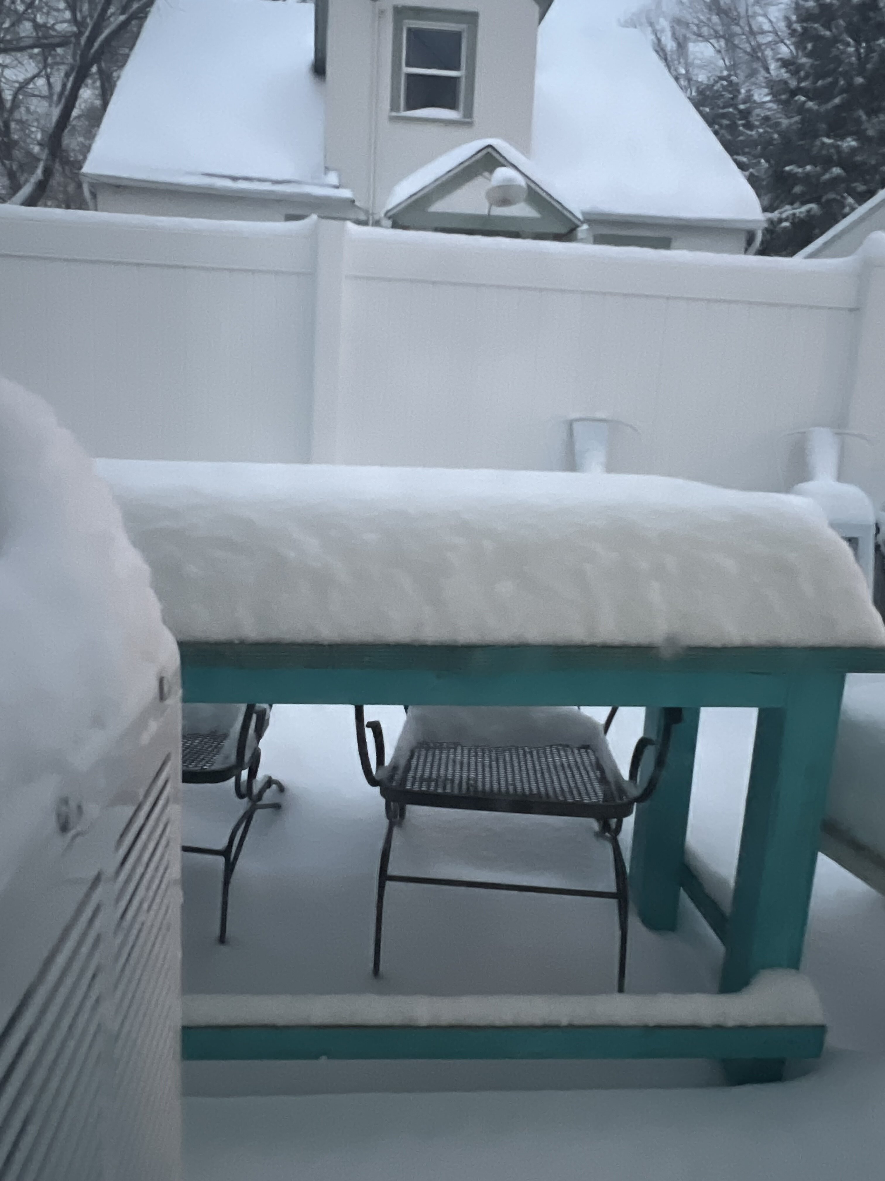
Obligatory “looking out the window to gauge accumulation” picture, first one while in Montana. Still snowing, supposed to taper off by noon. Will my first official storm here (was back east for the Thanksgiving one) give me the foot-plus I’ve been chasing for like a decade? Still coming down good currently.
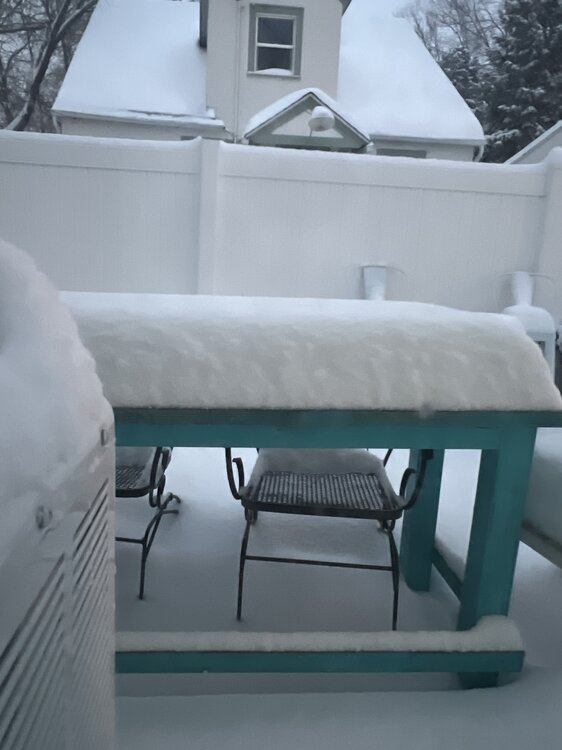
-

December 14th - Snow showers or Plowable snow?
Sey-Mour Snow replied to Sey-Mour Snow's topic in New England
Would be funny if we all got a coating to an inch or less and it was all done before sunrise so no one saw a flake.. -
Still like 1-3” area wide…
-

Minor snow possible sunday 12/14/25
BoulderWX replied to WeatherGeek2025's topic in New York City Metro
1-3 seems like a good call this AM; -
Once we get to Dec 17th, the SE will have had virtually every day colder than normal for 3 weeks. In addition, much of NC will have had 3 snows even though mainly minor. In the past few decades, only 2010 will have been clearly colder for that same period and 2002/2000 close, but none of those had 3 different snows in the RDU/GSO area. 1989 was the last time it was this cold and with 3 snows during this early period.