All Activity
- Past hour
-
Mine was 7th warmest and 8th driest here in Clifton
-

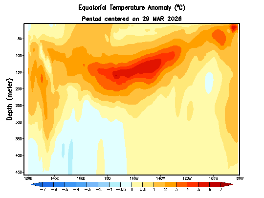
2026-2027 Strong/Super El Nino
LakePaste25 replied to Stormchaserchuck1's topic in Weather Forecasting and Discussion
It’s still notable that it could end up the warmest SST’s on record in that region. Maybe “strongest” is not the right word in terms of sensible atmospheric forcing. -
https://www.instagram.com/reel/DY-BOhHuChX/?igsh=MTZweDlmcG9iOTlwcQ==
-

Junorch obs and discussion 2026
TauntonBlizzard2013 replied to Damage In Tolland's topic in New England
How’s Saturday look? Have a cookout to go too. Looking forward to getting out of the house with the baby -
I'm wondering about the magnitude given to some recent obs. I mean it's not hugely scientific to say this, but it just doesn't feel like it's coming on in any particularly mean looking way. Historic anything in this business, tend to get busy real quick. It's not phenominalogically consistent to speed bump with so WWB's and like below Fwiw, this coarse looking product from CPC shows the sub warm plume as shrinking - not sure that's helping the intent to get this to super, less very strong.
-
Junorch obs and discussion 2026
TauntonBlizzard2013 replied to Damage In Tolland's topic in New England
Dog food weather for June 1st -
2026-2027 Strong/Super El Nino
LakePaste25 replied to Stormchaserchuck1's topic in Weather Forecasting and Discussion
I remember it doing pretty poorly early on before the 23-24 nino. If i remember it had a ‘09-‘10 redux with the canadian and -nao block and broad mid latitude troughing in CONUS. -
Wettest May on record with 10.31" for the month (previously 9.05" set in 1995). Washout of a month. Good riddance.
-
And we’re off…
-
I can’t speak to winter, but my full expectation given the conditions in the Atlantic is that the strengthening Nino will be even more suppressive than some of the current seasonal predictions.
-
I'd go ahead and cancel all outdoor plans and go with stable cool/wet weather - it fits the unrelenting persistence to seek out and destroy any free hours that collective civility would have any chance to experience. Don't fight it
-
 Where is Ji? He usually opens an early winter prognostication thread by March. it is time!!!
 -

E PA/NJ/DE Spring 2026 Obs/Discussion
RedSky replied to PhiEaglesfan712's topic in Philadelphia Region
NYC finished exactly normal for May 48F low -
 WxWatcher007 changed their profile photo
 -
-
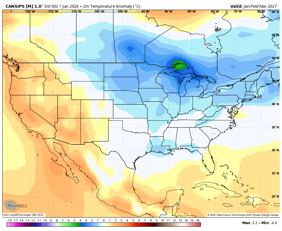
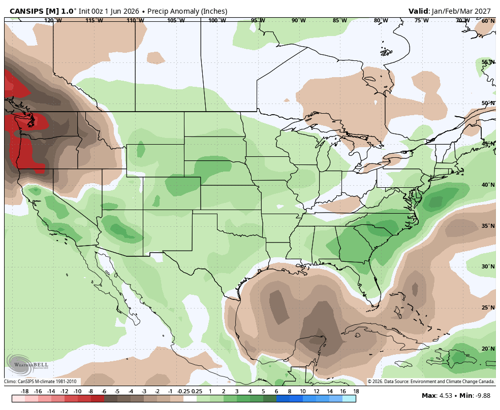
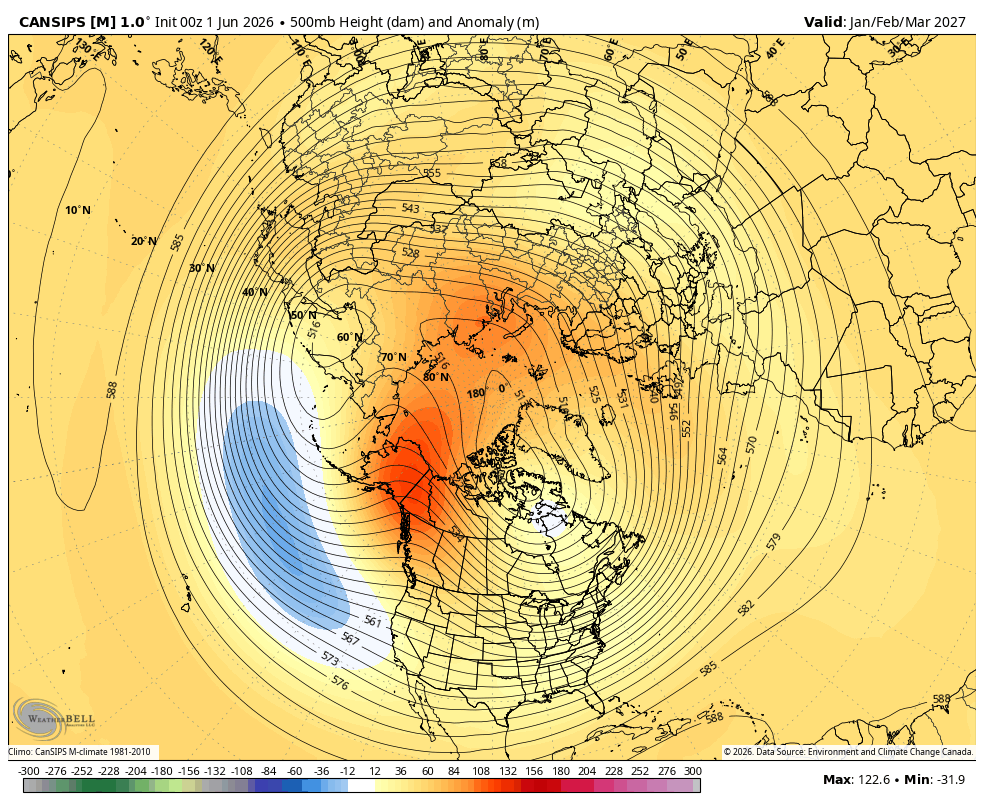
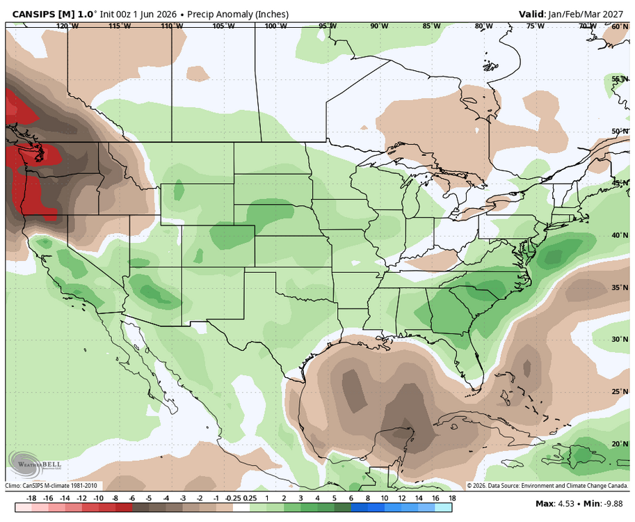
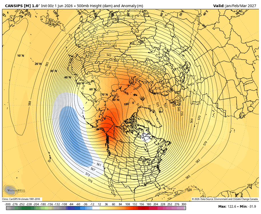
WB June Can. Long range for the winter. Hopefully just cold enough...

- 92 replies
-
- 1
-

-
- let the flood gates open
- oh thats where the moisture is
- (and 1 more)
-
Was there a synoptic reason for the relative precip minimum in the northern piedmont and NW coastal plain? During the recent wet period over and over again strong cells would drift SW to NE from SC but they would suddenly start to weaken a sthey went north, leaving us to get crumbs up here. Sometimes the remnant cell would actually actually seem to redeveloped after it moved past. Was that just bad luck?
-
Warmest meteorological spring in recorded history
-

Central PA Summer 2026 Discussion/Obs Thread
canderson replied to Voyager's topic in Upstate New York/Pennsylvania
Heat and big humidity kick in this weekend, it seems. Also a very, very dry pattern ahead. -
Hail falling w/o any rain is quite rare in New England, and the East Coast for that matter, owning to the more moist climate and lack of an EML the vast majority of the time.
-
So I have a question that someone relates to the June topic. I just posted in the winter form for this upcoming winter as well. I saw a few different posts now from different people saying they're expecting a Modoki El nino for the upcoming summer and winter. From what I'm reading, that gives us a completely opposite effect of a typical super El Nino. Meaning, not as hot of a summer, not as suppressed when it comes to hurricanes, and a colder stormy year pattern for the winter. Figured more people are in this current June discussion topic than they are right now in the winter discussion ( that's been crickets, as it should be )
-

2026-2027 Strong/Super El Nino
mitchnick replied to Stormchaserchuck1's topic in Weather Forecasting and Discussion
It didn't cave last year or the year before either fwiw, and did pretty well with the BN temps forecasts. - Today
-
So I'm just curious. I saw a few posts from different people saying that they're expecting this El nino to be a Modoki El Nino for the summer and winter. And they're saying with that it's opposite of a typical El nino. Just curious on thoughts from you guys on this
-
Woke up to rain/mist this morning...another dreary day.
-
I'd take the February 83 renegade storm and call it a win !
-
Op Euro looks dry through the middle of June. Hopefully the recent wet period was a sign of change and not an aberration. We need continued rain. The water table is still quite below average.