All Activity
- Past hour
-

2025-2026 Fall/Winter Mountain Thread
WinstonSalemArlington replied to Buckethead's topic in Southeastern States
-
Wow. What a sight to wake up to. GFS showing an almost 40 hour event. PHEW!
-
Imma hang here until Thursday.
-
Both AI models now have a very short window of mixing issues (if any).
-

January 2026 regional war/obs/disco thread
mreaves replied to Baroclinic Zone's topic in New England
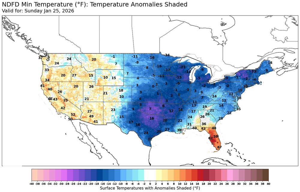
Well, it's obviously incorrect. The bullseye for VT is right over my head. We know that never happens. -

2025-2026 ENSO
40/70 Benchmark replied to 40/70 Benchmark's topic in Weather Forecasting and Discussion
I think it will be like January in that it will start cold the first week and then moderate for the middle third....then we see what the strat does. -
Im on the northern fringes right now
-

January 2026 regional war/obs/disco thread
Kitz Craver replied to Baroclinic Zone's topic in New England
As it stands, where do you see the line for the haves and have nots setting up? -

January 2026 regional war/obs/disco thread
Damage In Tolland replied to Baroclinic Zone's topic in New England
Ground zero at this juncture looks like TN down into NW Bama -
The Euro would be some nice ratios with the temps in the mid teens basically
-

Central PA Winter 25/26 Discussion and Obs
CAPE replied to MAG5035's topic in Upstate New York/Pennsylvania
From Google AI- Key Methods for Determining Snow Ratios in NBM: Temperature-Based Algorithms: The SLR is highly dependent on boundary layer and low-level temperatures (surface to 850 mb). Generally, colder air results in higher ratios (fluffy, dry snow), while temperatures near freezing produce lower ratios (wet, dense snow). Melting Rates for Marginal Temperatures: For temperatures at or above 32°F, the NBM v4.2 incorporates idealized melting rates. The total SLR is reduced based on the ratio of melting to accumulating snow, effectively lowering the ratio if the snow melts as it falls. Dynamic/Algorithm-Based Ratios: Instead of a default 10:1, the NBM uses algorithms that consider factors such as: Wind Speed: Higher wind speeds can lead to lower ratios due to snowflake fracturing. Cloud Structure: The presence of supercooled water droplets (higher riming) vs. depositional growth influences the ratio. Ensemble Member Blending: The NBM uses output from several models (HRRR, GFS, ECMWF) to calculate a probabilistic snowfall, utilizing the best-performing models to determine the most likely ratio for a given area. Elevation Adjustments: Ratios are adjusted upward at higher elevations to account for colder, drier conditions in mountainous terrain. -

Possible Record Breaking Cold + Snow 1/25 - 1/26
SACRUS replied to TriPol's topic in New York City Metro
GFS Total QPF: Euro AI AIFS: -

Central PA Winter 25/26 Discussion and Obs
mahantango#1 replied to MAG5035's topic in Upstate New York/Pennsylvania
It needs to come more north about 150- 200 more miles. Still time for it to do that. But will it? -

Winter 2025-26 Short Range Discussion
michsnowfreak replied to SchaumburgStormer's topic in Lakes/Ohio Valley
Obviously nowhere near as deep snow as 2013-14. But with the bitter winds and drifting snow, absolutely has the feels of severe winter. -
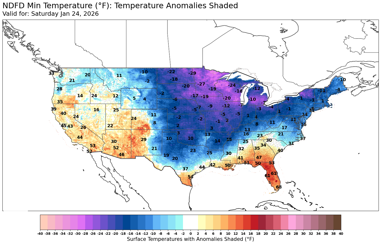
My guess is that NYC will be closer to 10° this weekend with the 0° readings in the outlying colder areas similar to the NDFD.

-
If the Euro comes to fruition, they’re honestly screwed.
-
Central PA Winter 25/26 Discussion and Obs
CAPE replied to MAG5035's topic in Upstate New York/Pennsylvania
That's what we are talking about lol. Already posted. -
Will see by the weekend what name the weather channel will give it. See what person gets the assignment to DC.
-

Winter 2025-26 Medium/Long Range Discussion
cyclone77 replied to michsnowfreak's topic in Lakes/Ohio Valley
Hopefully we'll have something to track in about 10-15 days. -
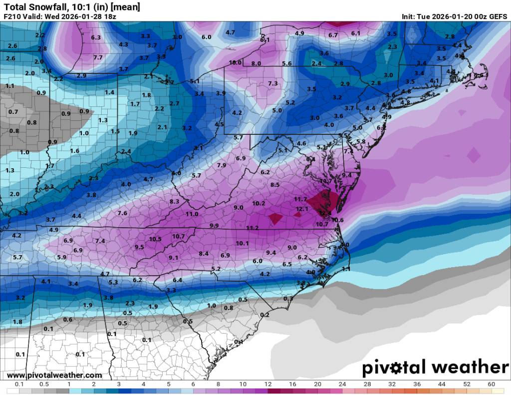
GEFS 10:1 snow mean. Not bad. Sent from my SM-G998U using Tapatalk

-
Possible Record Breaking Cold + Snow 1/25 - 1/26
SACRUS replied to TriPol's topic in New York City Metro
06Z Total QPF (NYC) GFS: 0.4 - 0.5 Euro AI AIFS: 0.9 - 1.1 Euro: through 144 looked more or less in line with the 1/20 00Z -
January 2026 regional war/obs/disco thread
Kitz Craver replied to Baroclinic Zone's topic in New England
That would be kind of rough for them, 0.0 infrastructure for big ice -

Richmond Metro/Hampton Roads Area Discussion
Conway7305 replied to RIC Airport's topic in Mid Atlantic
yeah, we need to halt the northern movement. Storm is transferring into a coastal and that pulls in warm air off the ocean. Regardless, we all start w/ snow, but as the coastal forms it might go to sleet I do not think we get those high accumulations because of sleet -

Possible Record Breaking Cold + Snow 1/25 - 1/26
binbisso replied to TriPol's topic in New York City Metro
15.5" mt vernon ny. Westchester County -
January 2026 regional war/obs/disco thread
Damage In Tolland replied to Baroclinic Zone's topic in New England
Massive icestorm down south. Some of those areas will be crushed and no power for weeks . And it’s cold after the storm too