All Activity
- Past hour
-
Euro just furnaces the week . Glad we installed

-
We Euro
-
 Sinlaku is now forecast to pass directly over Saipan and Tinian. Really hope it misses, as those islands have already had bad hits from typhoons (like Yutu) in recent years.
 -
Whatever? No eruptions and yet good winters through the 2000’s and 2000 teens. I can’t figure out where you’re going with this, and really don’t care. But it’s all good.
- Today
-
Mammoth got 18 inches last night. They just got upgraded to a foot of new snow today!
-
It's really super shallow, too. The 850 mb temp and wind layout really doesn't even speed up over that. It's all from 925 and lower
-
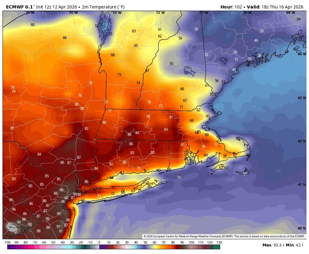
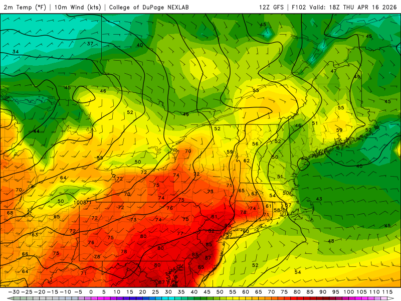
What a week for the heaters https://x.com/ericfisher/status/2043384233742246253?s=46&t=dhcbvkjmRcyBVQtDxJ3lRg
-

E PA/NJ/DE Spring 2026 Obs/Discussion
Voyager replied to PhiEaglesfan712's topic in Philadelphia Region
I was just going to say that there's a good one going near Palmerton. They're using helicopters to scoop water out of the Lehigh River to fight it. -
It comes through around sunrise for ENE with falling temps. There’s no moral victories on Thursday. Euro took a turn in this direction at 12z as well. Saturday may be salvageable.
-
Expecting Red Flag Warnings and some possible brush fires later this week. Rising temperatures, low humidity, some gusty winds and drying fuel.
-
APR 20 snowflakes in RIC
-
Looking forward to a full week of deep summer . Gonna be awesome .
-
I’ll compare 2026 to others. Here’s 2026 with its first strong -SOI period not til days 98-102: 2026 98 1010.27 1010.30 -17.45 2026 99 1009.30 1011.45 -32.74 2026 100 1009.19 1011.45 -33.53 2026 101 1009.56 1011.00 -27.62 2026 102 1010.69 1010.75 -17.67 1) 1994: already had strong -SOI days 75-90: 1994 75 1009.95 1009.25 -16.33 1994 76 1011.21 1009.00 -9.08 1994 77 1010.30 1008.65 -11.78 1994 78 1009.25 1009.30 -19.92 1994 79 1009.33 1009.25 -19.32 1994 80 1010.65 1008.60 -9.86 1994 81 1011.61 1009.45 -9.32 1994 82 1012.00 1010.25 -11.30 1994 83 1010.73 1009.80 -15.23 1994 84 1009.74 1010.30 -22.37 1994 85 1011.13 1011.00 -19.08 1994 86 1012.49 1011.90 -16.86 1994 87 1012.66 1011.95 -16.27 1994 88 1012.31 1012.15 -18.90 1994 89 1012.79 1011.85 -15.19 1994 90 1012.12 1011.85 -18.36 2) 1997: already had strong -SOI days 81-90: 1997 81 1011.33 1011.55 -20.69 1997 82 1009.53 1010.25 -23.08 1997 83 1009.46 1010.35 -23.92 1997 84 1009.17 1010.95 -28.17 1997 85 1009.38 1011.65 -30.50 1997 86 1008.01 1011.85 -38.04 1997 87 1007.55 1011.15 -36.91 1997 88 1010.10 1010.60 -22.07 1997 89 1011.92 1011.00 -15.24 1997 90 1011.97 1010.55 -12.85 3) 2002: already had strong -SOI days 72-80 2002 72 1010.71 1012.50 -28.24 2002 73 1010.25 1011.40 -25.18 2002 74 1011.11 1011.10 -19.62 2002 75 1010.70 1010.90 -20.63 2002 76 1009.60 1010.35 -23.27 2002 77 1010.04 1010.55 -22.13 2002 78 1012.20 1010.55 -11.78 2002 79 1013.25 1010.20 -5.07 2002 80 1010.45 1008.90 -12.26 4) 2004: already had strong -SOI days 87-97 2004 87 1010.56 1010.65 -20.11 2004 88 1009.84 1011.25 -26.42 2004 89 1009.20 1011.25 -29.49 2004 90 1008.64 1011.75 -34.56 2004 91 1007.47 1011.75 -40.16 2004 92 1006.10 1012.30 -61.94 2004 93 1005.85 1012.25 -63.38 2004 94 1006.74 1011.55 -51.92 2004 95 1005.93 1011.20 -55.23 2004 96 1007.71 1011.00 -40.96 2004 97 1008.59 1010.60 -31.73 5) 2014: already had strong -SOI days 73-80 2014 73 1010.53 1009.55 -14.98 2014 74 1009.38 1010.70 -25.99 2014 75 1008.55 1009.75 -25.42 2014 76 1009.09 1010.40 -25.94 2014 77 1009.21 1009.75 -22.26 2014 78 1007.89 1010.20 -30.73 2014 79 1007.49 1009.30 -28.34 2014 80 1009.69 1008.25 -12.78 6) 2015: already had strong -SOI days 67-79: 2015 67 1007.50 1008.10 -22.55 2015 68 1008.11 1008.65 -22.26 2015 69 1008.73 1008.20 -17.14 2015 70 1009.33 1008.65 -16.42 2015 71 1009.24 1008.45 -15.89 2015 72 1009.91 1007.55 -8.38 2015 73 1010.42 1007.65 -6.42 2015 74 1010.41 1008.90 -12.45 2015 75 1006.90 1010.15 -35.23 2015 76 1005.66 1009.05 -35.90 2015 77 1008.13 1008.65 -22.16 2015 78 1010.35 1009.55 -15.84 2015 79 1008.79 1011.20 -31.21 7) Even the non-Nino 2012, which psyched out the Euro, had an earlier strong negative period: 2012 90 1011.39 1009.80 -12.06 2012 91 1009.90 1010.70 -23.50 2012 92 1010.45 1011.70 -26.25 2012 93 1012.60 1012.20 -14.35 2012 94 1012.53 1013.55 -24.59 2012 95 1011.19 1013.45 -33.53 2012 96 1010.10 1012.15 -32.01 2012 97 1009.94 1011.85 -31.01 2012 98 1009.98 1011.60 -28.91 2012 99 1010.16 1011.65 -27.98 2012 100 1011.50 1011.45 -16.87 OTOH, 2026’s strong -SOI is ahead of 2006, 2009, 2018, and 2023.
-
I'll believe it when I see it from what we saw how models handled snow this winter.
-
What helped was a major volcano (Pinatubo). This caused global temperatures to drop temporarily, making it favorable for cold and snowy winters in 92-93, 93-94, and even 95-96. If not for that, then global temperatures would have broken records in 1992, following a 3rd robust el nino in a decade (after 1982-83 and 1986-88). But the cooling period was over by the 1997-98 super el nino, the fourth robust el nino in just over 15 years. Unless there is another Pinatubo this summer, I expect global temperatures to shatter another record (following a 2nd robust el nino in 4 years), making it unlikely we have another cold and snowy period like 92-93, 93-94, and 95-96.
-
 An absolute beast
 -
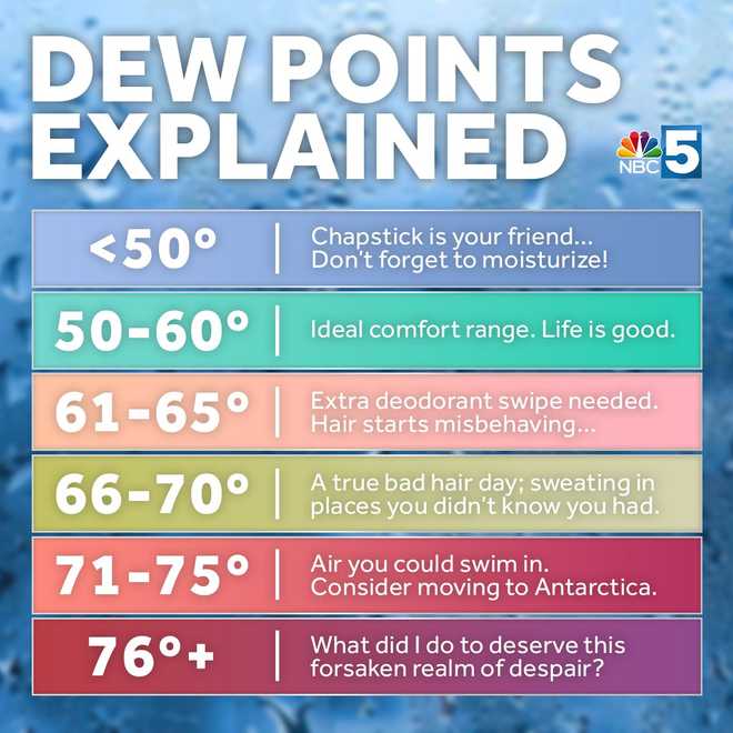
Muggy starting after a 70° dew is absurd. This looks like a good scale.
-
Sides, that doesn't look "ruined" to me "as is". It's probably a waste of time to discuss the snap shot, particularly at this range, but for shits and giggles.. we are still 558+ hydrostats when that front episodically slips S. It's not like that's we 540- bisecting Maine.
-
not to be a douche but I warned ya. It said this couple whatever days ago that it's very precarious given both our climatology, but the season's persistence/behavior, to sustain a stationary boundary with +PP running E of Ontario without it collapsing S. It may even go back N... ? sure. I just would be duly impressed if we actually got 5 or 6 days in a row of 70+ weather. Not given our climatology of mid April alone, but then including the way persistence has also been over the last 7 month, heh. That'd be pretty fantastic
-
Yore!
-
Yeah, I mean anecdotal and not trying to bait some warming discussion… but I genuinely remember being a lifeguard in high school at some local municipal pools and we’d sit in the office with the one computer hooked up to the Internet and look at Steve LaPoint’s WRGB forecasts for Albany (one of the first Mets with online forecasts in the area)… he’d post those charts and if it went above 60F dews we’d know the pool would be busy. Feels like it used to live in that 55-65F range for vast potions of the summer.
-
I removed the cover for the a/c compressor. If need be sleeping comfort is a touch screen away. But it’s way too early to expect consistent warmth around here.
-
This was made by someone in Tolland
-
SPC now has 30% risk for large hail in Minneapolis tomorrow
-
“Tropical” wasn’t even a thing.